Tamil Nadu CRZ
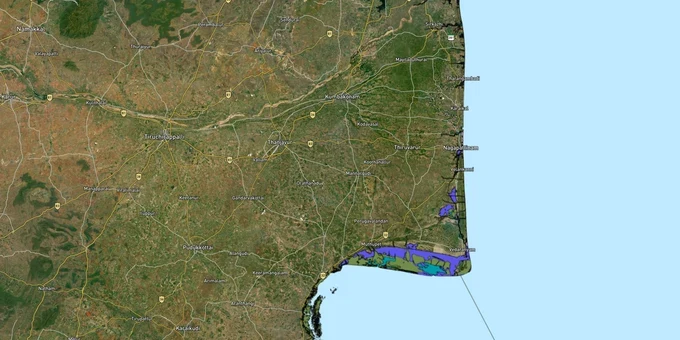
Tamil Nadu Crz Preview
Try the Tamil Nadu CRZ on the map
Sign in once and explore the layer for a full day.
- No card details needed
- Find nearby verified lands for sale
Overview
The Tamil Nadu CRZ layer plots the Coastal Regulation Zone footprint along the state's 1,076 km coastline, the second longest in India. It mirrors the approved Coastal Zone Management Plan (CZMP) prepared by NCSCM (National Centre for Sustainable Coastal Management) in 117 maps and approved by MoEFCC on 24 October 2018, under CRZ Notification 2011. The CRZ 2019 CZMP for Tamil Nadu is currently being prepared and has not yet received MoEFCC approval. CRZ 2011 rules and the 2018 CZMP remain operative until the CRZ 2019 CZMP is approved. The CRZ extends 500 metres landward from the High Tide Line and up to 100 metres along tidal creeks. This page shows what falls inside CRZ-I, II, III A, III B, and IV across all 14 coastal districts, and where construction is restricted.
The May 31, 2026 Madras HC deadline is imminent — the outcome will directly affect property status in the 798-notice belt from Neelankarai to Uthandi.
Regulatory Red Flags Inside the No Development Zone
Tamil Nadu's coastal belt is the most actively litigated CRZ zone in the country right now. The Madras High Court, in February 2026, gave the state until May 31 to dispose of 440 pending appeals on CRZ violations Chennai ECR (East Coast Road), tied to 798 notices issued by Greater Chennai Corporation in 2018-19 between Neelankarai and Uthandi.
Most violations sit inside the 500-metre belt from the High Tide Line, with 50+ structures reportedly inside the 200-metre No Development Zone (NDZ). The NGT has separately taken cognisance of beach encroachment near Besant Nagar, and ordered demolition at Radisson Blu Mamallapuram for structures inside the 200-metre belt.
The fact-pack on what each zone permits, drawn from CRZ Notification 2019 and TNSCZMA (Tamil Nadu State Coastal Zone Management Authority) classification.
Zone Code
Permitted Use
Requires CRZ Clearance?
Prohibited Without?
Commonly Misrepresented?
CRZ-I A
Mangroves, sand dunes, turtle nesting, reserve forests
No new construction; only strategic/utility
Any building
Sold as "sea view plots"
CRZ-I B
Inter-tidal area (LTL (Low Tide Line) to HTL (High Tide Line))
Pipelines, transmission, salt works only
Houses, resorts
Marketed as "beach plots"
CRZ-II
Built-up urban municipal areas
Yes, via TNSCZMA
New construction without CZMP layer reference
Confused with CRZ-III rural
CRZ-III A
Densely populated rural; NDZ 50 m from HTL
Beyond NDZ only
Construction inside 50 m
Quoted as "approved layout"
CRZ-III B
Sparse rural; NDZ 200 m from HTL
Beyond NDZ only
Anything inside 200 m
Sold without disclosure
CRZ-IV A/B
Sea up to 12 NM and tidal water bodies
Fishing, traditional use
Solid waste, mining
Not applicable to plots
If a seller cannot show you the survey number marked on the approved CZMP map, that plot does not have a clear CRZ status. Walk away.
Growth Corridors and Micro-Markets Along the Tamil Nadu Coast
Coastal value in Tamil Nadu is uneven. Some stretches are investable with full CRZ clearance Tamil Nadu in place. Others are speculative and trade entirely on the gamble that violation appeals will be regularised through post-facto clearance, a route the Centre opened in 2022 but that is being actively challenged in court.
The corridors land buyers ask about most, mapped against their CRZ exposure.
Corridor / Locality
Zone (CZMP 2018)
Growth Driver
Known Risk
Kottivakkam, Palavakkam, Neelankarai
CRZ-II (urban)
Chennai ECR, 8-9k/sqft apartments
798-notice belt; appeals pending
Uthandi, Kanathur, Akkarai
CRZ-II to CRZ-III boundary
DTCP/RERA gated layouts
Mixed CRZ-II/III parcels; verify via TNSCZMA
Mamallapuram (Chengalpattu)
CRZ-III + CRZ-I A pockets
UNESCO heritage, ECR widening
Radisson-style demolition orders
Marakkanam, Poonjeri
CRZ-III B largely
Resort plots near backwaters
NDZ 200 m enforced strictly
Cuddalore-Nagapattinam belt
CRZ-III B + CRZ-I A mangroves
Industrial backbone
Pichavaram mangrove buffer 50 m
Gulf of Mannar (Ramanathapuram)
CVCA (Critical Vulnerable Coastal Area) + CRZ-I A
Pearl coast tourism
CVCA blanket restriction
Kanyakumari coast
CRZ-III B + CRZ-I A
Tourism, fisheries
High erosion; PWD CRZ disputes
The most misunderstood corridor is the Uthandi-Akkarai stretch. Buyers assume DTCP or RERA approval clears the CRZ question. It does not. TNSCZMA clearance is a parallel approval, and a layout sanctioned in the 1980s before the 1991 notification does not exempt fresh construction inside today's NDZ.
Was this layer helpful?
Anything wrong, outdated, or missing we want to hear it.
For Land Owners & Agents
Looking to sell your land in Tamil Nadu?
I want to sell my land in Tamil Nadu
10:32
Plz share your Land's location - We will list it on 1acre map, for Free.
10:32

For Land Buyers
Browse all verified lands & plots in Tamil Nadu
Every listing goes through our Preliminary Verification Process.
More Layers in Tamil Nadu
See all 14 layers
Tamil Nadu Survey Number Map — Find Any Plot's Patta Free | 1acre.in
See any plot's survey number in Tamil Nadu on a free live map. Patta, Chitta, Adangal and FMB explained, plus which port...
Chennai CMDA Masterplan: Zone Check and Land Use Guide
View Chennai Masterplan as a live map overlay – check any plot's land use zone for free on 1acre.in. Chennai CMDA master...
Coimbatore Masterplan 2041: LPA Zone Check and Land Use Guide
View Coimbatore Masterplan as a live map overlay – check any plot's land use zone for free on 1acre.in. Coimbatore maste...
More Layers in Tamil Nadu
Tamil Nadu Survey Number Map — Find Any Plot's Patta Free | 1acre.in
See any plot's survey number in Tamil Nadu on a free live map. Patta, Chitta, Adangal and FMB explained, plus which port...
Chennai CMDA Masterplan: Zone Check and Land Use Guide
View Chennai Masterplan as a live map overlay – check any plot's land use zone for free on 1acre.in. Chennai CMDA master...
Coimbatore Masterplan 2041: LPA Zone Check and Land Use Guide
View Coimbatore Masterplan as a live map overlay – check any plot's land use zone for free on 1acre.in. Coimbatore maste...