Chennai Port - Maduravoyal Expressway
Chennai Port Maduravoyal Expressway Preview
Try the Chennai Port - Maduravoyal Expressway on the map
Sign in once and explore the layer for a full day.
- No card details needed
- Find nearby verified lands for sale
Overview
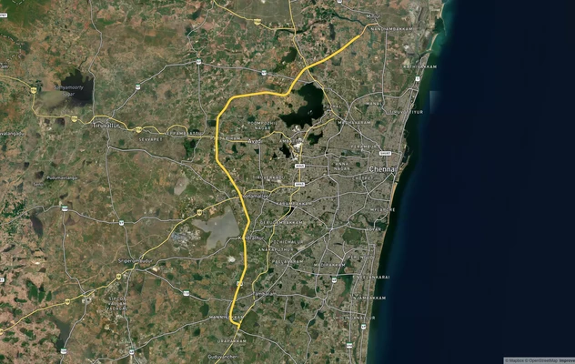
The Chennai Port Maduravoyal Expressway is a 20.6-km, six-lane, double-decker elevated corridor built by NHAI (National Highways Authority of India), running along the Cooum River from Chennai Port Gate 10 to Vanagaram, running along the Cooum River and NH-48 to Vanagaram, with a key interchange at Maduravoyal connecting to the Bengaluru–Chennai Expressway (NE-7). All four construction packages are awarded to J Kumar Infrastructure at a total contract value of Rs 5,510 crore. Current construction phase commenced January 2024; the current completion target is November 2027. This Premium layer on 1acre maps the alignment so buyers can assess corridor proximity and construction impact before any transaction near the route.
NGT Restrictions and Cooum Bank Exposure: The Construction Risk Facing Properties Along the Chennai Port Maduravoyal Expressway
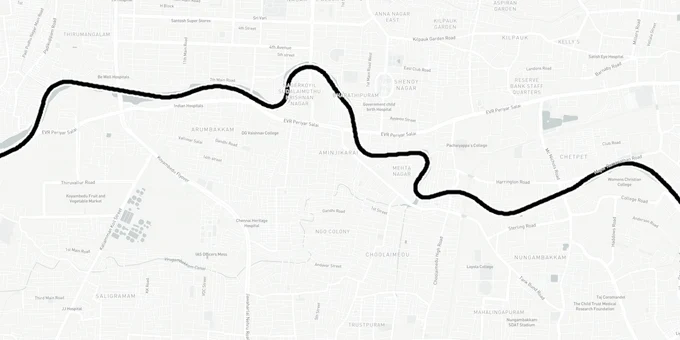
This expressway runs along the Cooum River from Chennai Port to Koyambedu, then along the NH-48 median to Vanagaram. It is an elevated corridor built over existing roads and a river bank, not a greenfield land acquisition zone. The risk for buyers near the alignment is construction impact and NGT environmental restrictions, not compulsory acquisition notices.
The NGT imposed seasonal work restrictions on construction between October and December 2024, citing Cooum River environmental protection. Those restrictions are expected to apply in subsequent monsoon seasons and directly affect project timelines. Properties along the Cooum bank between Napier Bridge and Koyambedu sit inside a zone where NGT oversight has been consistently active; any land or structure adjacent to this river corridor warrants NGT compliance verification as a due-diligence item alongside standard title checks.
Three factors have pushed the completion deadline from May 2026 to the first half of 2027: the Water Resources Department's slow handover of the Cooum river boundary to NHAI, NGT seasonal restrictions, and daytime traffic police curbs on construction vehicles. As of July 2025, progress across all four packages ranged from 3% to less than 10%, despite work commencing in January 2024.
The table below shows the four construction packages with their confirmed costs and progress as of July 2025:
Package
Contract Cost
Progress (July 2025)
Key Stretch
Package 1
Rs 1,388.59 crore
7.74%
Chennai Port to Chetpet
Package 2
Rs 1,616.97 crore
5.45%
Chetpet to Koyambedu
Package 3
Part of Rs 5,510 crore total
3-10%
Koyambedu to Poonamallee High Road
Package 4
Part of Rs 5,510 crore total
3-10%
Poonamallee High Road to Vanagaram
The 12.5-km double-decker section from Napier Bridge to Koyambedu will channel local traffic on the lower tier (13 ramps) and restrict the upper tier to port-bound heavy vehicles. Properties with frontage on Cooum-adjacent streets in this section face noise and access impacts through the full construction window into 2027. The project was first stalled in 2012 and revived only in 2022; any real estate return model built on a 2025 or 2026 completion date is already outdated.
Koyambedu to Vanagaram: Which Localities Along the Chennai Port Maduravoyal Expressway Corridor Hold Real Land Value
The 5.7-km single-deck section along Poonamallee High Road (Vanagaram to Koyambedu) and the double-decker Cooum section create two distinct sub-markets along this corridor; treating them as one unified zone is a valuation mistake. The expressway's clearest land value signal is concentrated at the termini and the Koyambedu interchange node, not evenly spread along the Cooum-bank stretch.
The table below shows key localities along the alignment with the realistic investment signal and primary construction risk:
Locality
Position
Land Signal
Key Risk
Maduravoyal
Western terminus; NH-48 junction
Logistics anchor; connects directly to NE-7
Already priced; limited new upside
Vanagaram
Single-deck section start
Poonamallee High Road elevation; developing
Construction disruption through 2027
Koyambedu
Mid-corridor; modified parclo (partial cloverleaf) interchange
Wholesale hub; 9% appreciation reported post-revival
Active construction; access disruption
Poonamallee High Road
NH-48 median stretch
Highway-adjacent logistics
Construction vehicle movement restrictions ongoing
Egmore/Nungambakkam
Near Cooum section
Heavy truck relief; residential quality gain
Indirect benefit; no direct expressway access
Chetpet
Cooum bank
Pillar construction active; residential area
NGT restrictions; Cooum-adjacent compliance needed
Maduravoyal is the most structurally sound position on this corridor. The cloverleaf interchange here already connects NH-48 to the broader Chennai bypass; the expressway adds a direct port link that completes the west-to-port logistics chain, making it the primary cargo throughput node for West Chennai. Properties near Koyambedu saw approximately 9% appreciation in the year following the 2022 project revival, but buyers entering now must price in active construction disruption through at least mid-2027. Chetpet and Cooum-bank parcels need specific NGT compliance verification before any purchase decision, separate from the general title and approval checks that apply elsewhere in Chennai.
Was this layer helpful?
Anything wrong, outdated, or missing we want to hear it.
For Land Owners & Agents
Looking to sell your land in Tamil Nadu?
I want to sell my land in Tamil Nadu
10:32
Plz share your Land's location - We will list it on 1acre map, for Free.
10:32

For Land Buyers
Browse all verified lands & plots in Tamil Nadu
Every listing goes through our Preliminary Verification Process.
More Layers in Tamil Nadu
See all 14 layers
Chennai CMDA Masterplan: Zone Check and Land Use Guide
View Chennai Masterplan as a live map overlay – check any plot's land use zone for free on 1acre.in. Chennai CMDA master...
Chennai Outer Ring Road
View the Chennai Outer Ring Road corridor on a live map overlay – check zoning, approvals and acquisition risk free on 1...
Chennai Peripheral Ring Road
View Chennai Peripheral Ring Road alignment as a live map overlay – check land acquisition risk and plot proximity free ...
More Layers in Tamil Nadu
Chennai CMDA Masterplan: Zone Check and Land Use Guide
View Chennai Masterplan as a live map overlay – check any plot's land use zone for free on 1acre.in. Chennai CMDA master...
Chennai Outer Ring Road
View the Chennai Outer Ring Road corridor on a live map overlay – check zoning, approvals and acquisition risk free on 1...
Chennai Peripheral Ring Road
View Chennai Peripheral Ring Road alignment as a live map overlay – check land acquisition risk and plot proximity free ...