Arang Masterplan
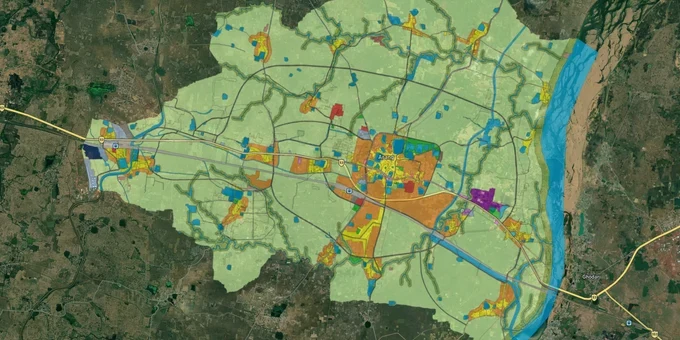
Arang Masterplan Preview
Try the Arang Masterplan on the map
Sign in once and explore the layer for a full day.
- No card details needed
- Find nearby verified lands for sale
Overview
Arang sits just east of Naya Raipur, which makes the Arang Master Plan 2031 one of the more important planning documents in the greater Raipur belt right now. TCP Chhattisgarh prepared it under the Chhattisgarh Nagar Tatha Gram Nivesh Adhiniyam, 1973, and it governs every land-use decision in Arang tehsil. Buyers coming in from outside Raipur routinely underestimate how strictly zone classifications are enforced here. This page covers exactly that: zone rules, diversion requirements, the infrastructure projects changing land values, and the corridors worth watching.Buying Land in Arang? The Diversion Trap Catches More Buyers Than Any Other Problem
Walk into any broker's office near the Arang-Kharora highway and you will find plots described as "residential, ready to construct." A large share of them are sitting on agricultural zone land with no diversion in place. That gap between what a broker says and what the revenue records show is where buyers lose money in Arang more than anywhere else.
Under Section 16 of the Chhattisgarh Nagar Tatha Gram Nivesh Adhiniyam, 1973, once a development plan is notified, changing land use away from what the TCP map shows requires written permission from the Director of Town and Country Planning. Agriculture gets a free pass in the other direction; the Director cannot refuse a request to convert to agricultural use. Residential construction on agricultural land? That needs formal diversion. No exceptions.
Zone Categories for Arang Residential Land
The table below shows the zone categories you will actually encounter when buying Arang residential land in Raipur.
Zone
Permitted Use
Needs Diversion to Build?
Watch Out For
Residential
Housing, plotted development
No
Confirm layout has TCP or RERA CG approval
Agricultural
Farming, horticulture
Yes, TCP Director's written permission required
Most misrepresented zone in Arang transactions
Industrial
Manufacturing, warehousing
Yes, for any residential use
Check abutting zone near Siltara belt
Green / Open Space
Parks, green belt only
Construction not permitted
Sold as "future residential" by some brokers
Pull the Bhuiyan Khasra from the CG Bhuiyan portal before you agree to anything. Check the land's zone against the TCP masterplan map on 1acre. If a formal diversion order is not already sitting in the revenue records, the legal exposure is yours after registration, not the seller's. Any broker who cannot show you a diversion order for agricultural land should not get another minute of your time.
Growth Corridors Near Arang: What the Expressway Changes and What It Does Not
Arang is at an interesting inflection point. The 92 km Durg-Raipur-Arang Expressway (NH53) under Bharatmala Pariyojana is real. NHAI started land acquisition in 2020, invited tenders in June 2022, and the total estimated project cost stands at Rs 2,297 crore. This six-lane access-controlled highway ties directly into Naya Raipur and slots into the Mumbai-Kolkata Economic Corridor, putting Arang at the eastern anchor of a major freight route. That has already moved asking prices on land along the state highway belt.
But the expressway hype is also where buyers make a second costly mistake: paying infrastructure-corridor premiums for undiverted agricultural land that cannot legally be built on. Know what you are buying before you pay for what the road might eventually do.
Corridor
Primary Zone
Growth Driver
Risk
Arang-Kharora State Highway belt
Mixed / Transitional
NH53 expressway corridor
Distress sales with unresolved title disputes
Nardaha-Arang fringe
Residential (township approved)
Naya Raipur proximity, RERA-registered projects
Verify RERA CG number before any booking
Pathuriadiya belt
Agricultural / Semi-urban
Low entry cost, Arang tehsil location
Undiverted plots sold as investment land
Arang town core
Residential / Commercial
Atal Awas Yojana housing board schemes
Limited upside; primarily local end-user demand
The Nardaha-Arang fringe is the most investable corridor if you want clean title and legal clarity. RERA-registered township projects here have gone through the approvals process, which means the diversion and TCP sanction work is already done. The Pathuriadiya belt, by contrast, is interesting on price but needs more legal homework than most buyers do before signing.
Was this layer helpful?
Anything wrong, outdated, or missing we want to hear it.
For Land Owners & Agents
Looking to sell your land in Chhattisgarh?
I want to sell my land in Chhattisgarh
10:32
Plz share your Land's location - We will list it on 1acre map, for Free.
10:32

For Land Buyers
Browse all verified lands & plots in Chhattisgarh
Every listing goes through our Preliminary Verification Process.
More Layers in Chhattisgarh
See all 12 layers
Balodabazaar Masterplan
View Balodabazaar Masterplan as a live map overlay – check any plot's land use zone for free on 1acre.in. Baloda Bazaar ...
Bhatapara Masterplan
View Bhatapara Masterplan as a live map overlay – check any plot's land use zone for free on 1acre.in. Bhatapara Master ...
Durg-Bhilai Masterplan
View Durg-Bhilai Masterplan as a live map overlay – check any plot's land use zone for free on 1acre.in. Durg Bhilai mas...
More Layers in Chhattisgarh
Balodabazaar Masterplan
View Balodabazaar Masterplan as a live map overlay – check any plot's land use zone for free on 1acre.in. Baloda Bazaar ...
Bhatapara Masterplan
View Bhatapara Masterplan as a live map overlay – check any plot's land use zone for free on 1acre.in. Bhatapara Master ...
Durg-Bhilai Masterplan
View Durg-Bhilai Masterplan as a live map overlay – check any plot's land use zone for free on 1acre.in. Durg Bhilai mas...