Raipur Air Funnel Zones
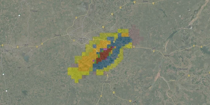
Raipur Air Funnel Zones Preview
Try the Raipur Air Funnel Zones on the map
Sign in once and explore the layer for a full day.
- No card details needed
- Find nearby verified lands for sale
Overview
Raipur airport funnel zone rules apply across a 56 km radius from Swami Vivekananda Airport's aerodrome reference point because the airport (ICAO: VERP) is classified as an IFR airport under AAI's official aerodrome list. The airport sits at Mana, 15 km southeast of Raipur city and 10 km east of Naya Raipur, at an elevation of 317.29 m AMSL. Its single runway 06/24, extended to 3,250 m in August 2024, runs northeast-southwest. The governing document is the color coded zoning map published by AAI under GSR 751(E), 2015.
The High-Plateau AMSL Trap: Why Raipur Airport Height Restrictions Work Differently
Raipur airport sits at 317.29 m AMSL, the highest elevation of any major central Indian airport. That figure changes the funnel zone calculation in a way most buyers miss entirely. The Permitted Top Elevation in the CCZM is stated in AMSL, so a plot near Mana village that sits at, say, 310 m AMSL and carries a CCZM ceiling of 360 m AMSL has only 50 m of permitted building height above ground. An equivalent ceiling in Mumbai would deliver far more usable floors, because Mumbai's airport sits at just 14 m AMSL. The plateau elevation compresses the margin between AMSL ceiling and ground elevation for every plot near the airport.
The table below shows how permitted building height works across the key obstacle limitation surfaces around Raipur airport's runway 06/24.
Zone Type
Distance from Runway
Height Rule
AAI NOC Required?
Approach / Funnel Surface
Along runway 06/24 axis (northeast-southwest), up to ~9 km
2% of distance from runway edge
Mandatory in all cases
Inner Horizontal Surface
Within ~4 km of runway ends
Max ~45 m AGL
Yes, if CCZM grid is red
Conical Surface
4-15 km from ARP
Gradient slopes upward at 5%
Depends on CCZM grid color.
Outer Horizontal Surface
15-56 km from ARP (IFR airport)
Generally permissive; local bylaws dominate
Required if building exceeds CCZM PTE
Tier-2 cities like Raipur see more permissive height thresholds than metros: at 4 km from the airport, Mumbai requires AAI approval for buildings above 17.87 m, while IFR tier-2 airports typically allow far more height at the same distance before triggering mandatory NOC. Confirm your individual CCZM grid from the NOCAS portal before drawing up any floor plan, because the plateau elevation means the effective AGL allowance varies sharply between plots, even a few hundred meters apart.
Mana, Arang, Abhanpur, Naya Raipur: Which Corridors the Raipur Funnel Zone Affects Most
Raipur's fastest-growing real estate corridors cluster around three axes: the Naya Raipur government city to the west of the airport, the Naya Raipur-Arang Road running east, and the Abhanpur belt along NH130C to the south. The airport's runway 06/24 orientation means the funnel zone's most restrictive approach surfaces extend northeast toward old Raipur city and southwest toward Abhanpur.
The table below maps key Raipur corridors against their funnel zone constraint profile.
Corridor / Locality
Airport Distance
Constraint Level
Growth Driver
Key Risk
Mana / Barauda (village adjacent to airport)
0-2 km
Very High (approach funnel + inner surface)
Airport-linked land demand; logistics
Lowest height allowance in Raipur district; most parcels red-grid
Arang (along Naya Raipur-Arang Road)
~10-12 km (east)
Moderate
Agricultural land; NH connectivity; affordable entry price
Approach funnel axis runs northeast; verify CCZM grid for each survey number
Abhanpur (NH130C corridor)
~8-12 km (southwest)
Moderate to High
State highway connectivity; plotted township projects active
Southwest of runway 24 end; conical and approach surfaces overlap; check grid
Naya Raipur (government city, sectors west of airport)
~10-14 km (west-northwest)
Low to Moderate
State capital planned city; RERA-registered projects; TCP approvals
Beyond critical funnel; local TCP bylaws dominate but 56 km IFR radius still applies
Kharora / Tilda (northeast corridor)
~15-20 km (northeast)
Low
Industrial belt; NH approaching Bilaspur
Beyond inner funnel; conical surface CCZM grid check still advisable
Abhanpur is the corridor most likely to surprise buyers. Plotted township projects on NH130C marketed as Naya Raipur-adjacent are positioned southwest of the airport's runway 24 end, directly under the approach surface. The 2% funnel slope formula means that at 2,000 m from the runway edge, the ceiling is only 40 m above ground. Sellers in Abhanpur routinely omit this. Ask for the CCZM grid number of the specific plot survey number before you discuss price.
Was this layer helpful?
Anything wrong, outdated, or missing we want to hear it.
For Land Owners & Agents
Looking to sell your land in Chhattisgarh?
I want to sell my land in New Raipur
10:32
Plz share your Land's location - We will list it on 1acre map, for Free.
10:32

For Land Buyers
Browse all verified lands & plots in Chhattisgarh
Every listing goes through our Preliminary Verification Process.
More Layers in Chhattisgarh
See all 12 layers
Arang Masterplan
View Arang Masterplan as a live map overlay – check any plot's land use zone for free on 1acre.in. Arang Master Plan 203...
Balodabazaar Masterplan
View Balodabazaar Masterplan as a live map overlay – check any plot's land use zone for free on 1acre.in. Baloda Bazaar ...
Bhatapara Masterplan
View Bhatapara Masterplan as a live map overlay – check any plot's land use zone for free on 1acre.in. Bhatapara Master ...
More Layers in Chhattisgarh
Arang Masterplan
View Arang Masterplan as a live map overlay – check any plot's land use zone for free on 1acre.in. Arang Master Plan 203...
Balodabazaar Masterplan
View Balodabazaar Masterplan as a live map overlay – check any plot's land use zone for free on 1acre.in. Baloda Bazaar ...
Bhatapara Masterplan
View Bhatapara Masterplan as a live map overlay – check any plot's land use zone for free on 1acre.in. Bhatapara Master ...