Jagdalpur Masterplan
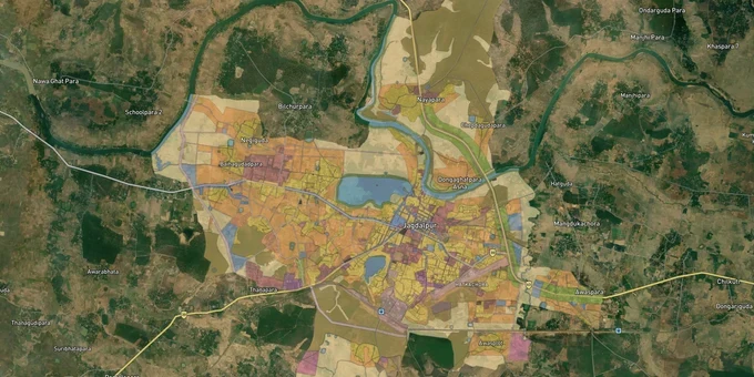
Jagdalpur Masterplan Preview
Try the Jagdalpur Masterplan on the map
Sign in once and explore the layer for a full day.
- No card details needed
- Find nearby verified lands for sale
Overview
The Jagdalpur Master Plan 2021 governs land use across Jagdalpur town and its planning area in Bastar district, Chhattisgarh. Prepared by the Directorate of Town and Country Planning (DTCP), Chhattisgarh, and implemented in 2011 with a validity period through 2021, the plan sets zone classifications for residential, commercial, industrial, and public use land within the municipal limits. For any buyer, knowing the Jagdalpur masterplan land zone for a specific Khasra is the first step, but Bastar's Fifth Schedule status adds a second layer of legal complexity that most buyers from outside the region never anticipate. This page covers both.
Why Bastar's Fifth Schedule Status Makes Jagdalpur Land Transactions Uniquely Risky
Jagdalpur sits in Bastar district, which is a Scheduled Area under the Fifth Schedule of the Constitution of India. This single fact changes the legal framework for land transactions more than any zoning designation in the Master Plan 2021.
Under constitutional Fifth Schedule protections, the Governor of Chhattisgarh is empowered to prohibit or restrict the transfer of land from Scheduled Tribe (ST) members. The Chhattisgarh Land Revenue Code carries provisions specific to notified Scheduled Areas that make the transfer of tribal land to a non-tribal void if Collector permission was not obtained. In 2020, the Chhattisgarh government ended the rule that had permitted tribal land acquisition on a mutual-agreement basis, tightening the restrictions further. A sale deed executed without Collector sanction on ST-held land in Jagdalpur is not merely irregular; it has no legal standing and can be restored to the original tribal owner by revenue authorities without compensation to the buyer.
This is not a theoretical risk. The combination of post-development pressure from the Nagarnar Steel Plant corridor, land scarcity in Jagdalpur's urban core, and broker activity has created a market where non-tribal buyers are being offered land whose transfer chain has a legally invalid link somewhere in the past. The Chhattisgarh RERA portal has been live since November 2017, and all plotting projects above 500 sq mt within the DTCP jurisdiction must be registered. Unregistered plot schemes selling in Jagdalpur are a known and documented problem across Chhattisgarh.
The table below maps the three risk categories specific to Jagdalpur land transactions.
Risk Type
Legal Basis
Practical Check
ST-to-non-tribal transfer without Collector sanction
Fifth Schedule + CG Land Revenue Code
Trace every transfer in the chain; any ST-to-non-ST link needs Collector approval on file
Unregistered plot scheme
Chhattisgarh RERA Act 2016 (live Nov 2017)
Verify RERA registration at rera.cgstate.gov.in before any payment
Layout without DTCP approval
CG Town and Country Planning Act 1973
Confirm DTCP layout approval reference at albpms-dtcp.cgstate.gov.in
No sale deed covers a transfer that violates Fifth Schedule protections. If a broker cannot produce the Collector sanction for any ST-origin parcel in the chain, stop the transaction.
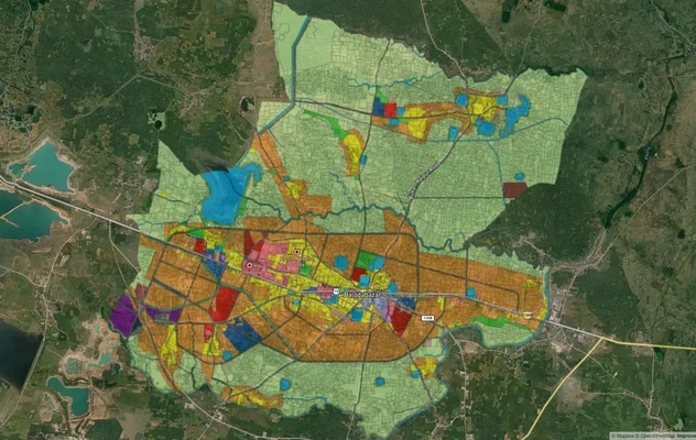
Jagdalpur's Three Investable Corridors: Nagarnar Highway, Hatkachora, and Dharampura
Jagdalpur's land market in 2025–2026 is shaped by one dominant infrastructure event: the NMDC Nagarnar Steel Plant on NH-30, 16 km from town, built at a cost of approximately ₹24,000 crore and reaching rated capacity in April 2025. The industrial demand that the plant generates is real, concentrated, and now confirmed, not speculative.
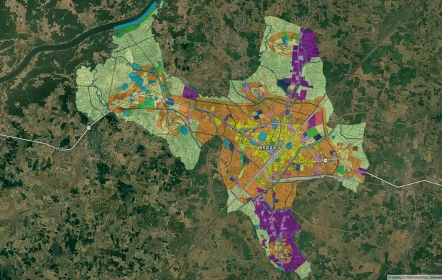
The Nagarnar NH-30 corridor is the strongest plan-backed growth zone. Plots marketed as "8 km from Nagarnar highway" or "2 km from the highway" directly reference proximity to this route. Residential plots on and near this road have active listings and confirmed buyer interest from plant-linked workers and contractors. The second tier comprises Hatkachora and Dharampura, the two localities where RERA-registered housing society projects are actively operating inside the municipal planning area. These have DTCP-approved layouts and Chhattisgarh RERA registration numbers on file. The third locality group is Tokapal, roughly 15 km from Jagdalpur on the highway toward Odisha, which is drawing interest from buyers looking for agricultural land with connectivity. The risk is higher because of its distance from the Jagdalpur municipal planning boundary.
The table below maps corridor quality against known risk.
Corridor / Locality
Growth Driver
Risk Level
NH-30 / Nagarnar highway (within 8 km of the plant)
NMDC Steel Plant ₹24,000 crore, operational April 2025
Medium (verify ST land chain)
Hatkachora, Dharampura (municipal core)
RERA-registered projects, DTCP layouts
Low (for RERA-registered schemes only)
Airport Road, Kalipur
Jagdalpur airport connectivity, Jagdalpur town expansion
Medium
Tokapal (15 km, Odisha border direction)
NH adjacency, agricultural value
High (outside planning boundary; ST land risk elevated)
The most misunderstood corridor is Tokapal. Its proximity to the Odisha border, its agricultural character, and its distance from the DTCP planning boundary all place it outside the Jagdalpur Master Plan 2021 zone. Buyers here are outside any masterplan protection and inside Fifth Schedule restrictions simultaneously, the worst combination.
Was this layer helpful?
Anything wrong, outdated, or missing we want to hear it.
For Land Owners & Agents
Looking to sell your land in Chhattisgarh?
I want to sell my land in Chhattisgarh
10:32
Plz share your Land's location - We will list it on 1acre map, for Free.
10:32

For Land Buyers
Browse all verified lands & plots in Chhattisgarh
Every listing goes through our Preliminary Verification Process.
More Layers in Chhattisgarh
See all 12 layers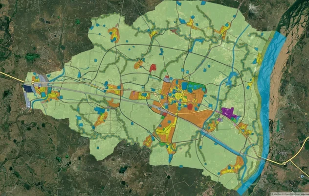
Arang Masterplan
View Arang Masterplan as a live map overlay – check any plot's land use zone for free on 1acre.in. Arang Master Plan 203...
Balodabazaar Masterplan
View Balodabazaar Masterplan as a live map overlay – check any plot's land use zone for free on 1acre.in. Baloda Bazaar ...
Bhatapara Masterplan
View Bhatapara Masterplan as a live map overlay – check any plot's land use zone for free on 1acre.in. Bhatapara Master ...
More Layers in Chhattisgarh
Arang Masterplan
View Arang Masterplan as a live map overlay – check any plot's land use zone for free on 1acre.in. Arang Master Plan 203...
Balodabazaar Masterplan
View Balodabazaar Masterplan as a live map overlay – check any plot's land use zone for free on 1acre.in. Baloda Bazaar ...
Bhatapara Masterplan
View Bhatapara Masterplan as a live map overlay – check any plot's land use zone for free on 1acre.in. Bhatapara Master ...