Rajnandgaon Masterplan
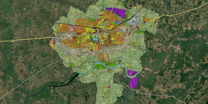
Rajnandgaon Masterplan Preview
Try the Rajnandgaon Masterplan on the map
Sign in once and explore the layer for a full day.
- No card details needed
- Find nearby verified lands for sale
Overview
Rajnandgaon master plan zone land buying starts with one document most buyers never ask for. The Master Plan 2031, prepared under the Chhattisgarh Town and Country Planning Act 1973 and administered by the state's Directorate of Town and Country Planning (DTCP), assigns every survey number in the planning area a permitted land use: residential, commercial, industrial, agricultural, or public utility. That classification controls what gets built, at what density, and on whose authority. This page covers the zone trap Rajnandgaon buyers keep falling into, which corridors are worth watching under the plan, and the exact steps to check any plot before money changes hands.
Rajnandgaon's zone trap: two permissions, one contradiction
Chhattisgarh's TCP system splits authority between two bodies, and that split is where buyers get hurt. DTCP controls the masterplan zone classification. Nagar Palika Nigam Rajnandgaon controls building permissions. Both issue separate documents. The problem is they sometimes say different things about the same land.
In January 2026, DTCP's inspection committee confirmed exactly this in Gram Nandai, Rajnandgaon district. A colonizer held a DTCP vikas anugya issued only for residential layout development. Nagar Palika had separately granted building permits for mixed commercial-residential structures on the same land. The inspection found construction underway in direct violation of the approved zone classification. DTCP recommended cancellation of all commercial building permits under CG Land Development Rules 1984 (Rule 25), sealing of unauthorized structures under Rule 34(4), and disciplinary action against municipal officers and the colonizer under the CG Nagar Palika Colonizer Registration Rules 2013.
The table below shows the three documents every Rajnandgaon buyer must independently verify before any advance payment.
Document
What it proves
The specific risk
DTCP Vikas Anugya
Master plan zone classification and approved use
Issued for residential only; colonizers market the same land as commercial
Nagar Palika Building Permission
Construction category approved by municipality
Can contradict DTCP zone; a valid building permit does not override zone classification
Approved Layout (Abhiinyas) Map
Sanctioned plot boundaries, road widths, EWS reservations
Deviations from approved layout have triggered sealing orders in Rajnandgaon district
A broker showing you only the Nagar Palika building permission is showing you half the picture. Ask specifically for the DTCP vikas anugya. If they cannot produce it, the zone status of that land is unverified.
Rajnandgaon growth corridors: which areas the plan actually supports
Rajnandgaon sits on the Mumbai-Howrah rail line and on the national highway network, so connectivity is not the issue here. The issue is whether the zone classification under the master plan supports the use being sold to you.
The table below maps the main corridors buyers are currently active in against the plan-level risks each carries.
Corridor / Locality
Growth driver
Plan-level risk
Basantpur
Peripheral residential expansion, large agricultural parcels
Agricultural land here needs a formal diversion order before any construction is legal
Dongragarh
Religious tourism, industrial parcels, railway connectivity
Industrial zone surroundings; residential development rights are not automatic
Khairagarh
University town, steady residential demand
Peri-urban plots may fall outside the notified plan area entirely; DTCP jurisdiction must be confirmed
Dongargaon
NH corridor, active residential and agricultural listings
Road widening acquisition notices active; highway setback distances under the plan restrict buildable area
Patewa node
Electronics Manufacturing Cluster received establishment consent in 2025
Industrial zone adjacency can restrict residential use on nearby plots under the plan
The proposed Kawardha-Rajnandgaon-Bhanupratappur national highway (482 km, raised by the Chhattisgarh government with Union Minister Gadkari in July 2024) has no gazetted notification as yet. But Bharatmala land acquisition notices have already been issued in Rajnandgaon district. Plots near the proposed alignment sit in transport zone reservation territory under the master plan. That reservation overrides residential development rights.
Dongargaon is the corridor most buyers misjudge. Highway frontage feels like an advantage. Under the Rajnandgaon master plan, it comes with a mandatory setback distance from the highway boundary. Any portion of a plot within that setback cannot be developed for residential use, regardless of what the seller's brochure says about the location.
Was this layer helpful?
Anything wrong, outdated, or missing we want to hear it.
For Land Owners & Agents
Looking to sell your land in Chhattisgarh?
I want to sell my land in Chhattisgarh
10:32
Plz share your Land's location - We will list it on 1acre map, for Free.
10:32

For Land Buyers
Browse all verified lands & plots in Chhattisgarh
Every listing goes through our Preliminary Verification Process.
More Layers in Chhattisgarh
See all 12 layers
Arang Masterplan
View Arang Masterplan as a live map overlay – check any plot's land use zone for free on 1acre.in. Arang Master Plan 203...
Balodabazaar Masterplan
View Balodabazaar Masterplan as a live map overlay – check any plot's land use zone for free on 1acre.in. Baloda Bazaar ...
Bhatapara Masterplan
View Bhatapara Masterplan as a live map overlay – check any plot's land use zone for free on 1acre.in. Bhatapara Master ...
More Layers in Chhattisgarh
Arang Masterplan
View Arang Masterplan as a live map overlay – check any plot's land use zone for free on 1acre.in. Arang Master Plan 203...
Balodabazaar Masterplan
View Balodabazaar Masterplan as a live map overlay – check any plot's land use zone for free on 1acre.in. Baloda Bazaar ...
Bhatapara Masterplan
View Bhatapara Masterplan as a live map overlay – check any plot's land use zone for free on 1acre.in. Bhatapara Master ...