Raigarh Air Funnel Zones
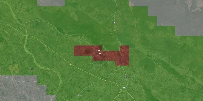
Raigarh Air Funnel Zones Preview
Try the Raigarh Air Funnel Zones on the map
Sign in once and explore the layer for a full day.
- No card details needed
- Find nearby verified lands for sale
Overview
Raigarh Airport height restriction zone rules apply to every plot within 20 km of the Aerodrome Reference Point of Raigarh Airport (JSPL), a VFR airfield near Kondatarai village, approximately 9 km south of Raigarh city in Chhattisgarh. The airfield sits at an elevation of approximately 240 m AMSL and operates a single runway (10/28) measuring 2,020 m in length and is owned by Jindal Steel and Power Limited (JSPL). All structures within this 20 km radius require an AAI height clearance NOC under GSR 751(E) before construction.
The VFR Classification and the Private Ownership Trap That Most Raigarh Buyers Overlook
Two facts about Raigarh airport catch buyers off guard. First, it is a VFR (Visual Flight Rules) airport. Under GSR 751(E), a VFR airport triggers the 20 km NOC radius, not the wider 56 km radius that applies to IFR airports. Second, the airfield is privately owned and operated by JSPL, not by AAI. GSR 751(E) explicitly covers state-owned and private aerodromes licensed by DGCA: the NOC requirement applies regardless of whether the operator is a public or private entity. Buyers near Kondatarai, Gharghoda, and Chakradhar Nagar who assume a JSPL-owned airfield carries no regulatory restriction are wrong.
Funnel Zone Height Constraints Along Raigarh Runway 10/28
The funnel zone along runway 10/28 is the tightest constraint. It runs east-west through Kondatarai and the surrounding villages. Inside it, the permitted height equals 2% of the distance from the runway edge in meters AGL. The runway threshold of 28 has a displaced threshold of 1,285 m, which alters where the effective funnel zone boundary begins on the eastern approach. The table below maps the main OLS zones around Raigarh Airport.
Zone
Distance Reference
Max Permitted Height
NOC Required?
Runway Strip (No-build)
0–500 m from runway edge
No construction
N/A
Inner Horizontal Surface
Up to 4 km from ARP
45 m AGL
Yes, AAI mandatory
Airport Funnel (Approach path)
Along runway 10/28
2% of distance from runway edge
Yes, AAI mandatory
Conical Surface
4–8 km approx.
Increases 1 m per 20 m of distance
Yes, AAI mandatory
Outer Horizontal Surface
Up to 15 km from ARP
Up to 300 m AMSL
Yes, AAI mandatory
Peripheral Zone
15–20 km
No hard cap, monitored
Yes, AAI mandatory
Because Raigarh Airport sits at approximately 240 m AMSL, and the surrounding terrain in Chhattisgarh's Raigarh basin is broadly similar in elevation, the AMSL calculation here is relatively straightforward compared to hilly airport sites. But AAI still measures height in AMSL. Submit your plot's surveyed site elevation in WGS84 coordinates through NOCAS before finalizing any construction plan.
Kondatarai, Gharghoda, Chakradhar Nagar and the JSPL Industrial Belt: Where Height Ceilings and Development Demand Collide
Raigarh is a steel and coal hub. JSPL's integrated steel plant drives demand for housing, commercial development, and industrial logistics within a 15 km radius of the airport. That demand and the airport's funnel zone cover much of the same geography. Plots marketed on Dhimrapur Road and in Chakradhar Nagar are pitched on industrial growth, but they can still sit inside the NOC radius if they are within 20 km of the Kondatarai airfield.
The table below maps the corridors most active in the Raigarh land market and the NOC zone risk each carries.
Corridor / Locality
Approx. Distance from ARP
Primary Zone Risk
Key Demand Driver
Kondatarai village
0–2 km
Funnel zone: extreme restriction
Airfield boundary, JSPL access
Bade Atarmuda
3–6 km (est.)
Conical / inner horizontal surface
Residential colony growth
Gharghoda
10–15 km (est.)
Outer horizontal surface
Road corridor, coal logistics
Chakradhar Nagar
Within city
Verify via NOCAS
Urban residential demand
Dhimrapur Road
Within city
Verify via NOCAS
Road-facing commercial plots
The most misread corridor in Raigarh is Kondatarai itself. Because JSPL controls the airfield and uses it primarily for industrial and business aviation, local brokers often treat the surrounding land as purely industrial with no aviation constraint. That is factually wrong. The GSR 751(E) NOC requirement does not depend on whether the airport has commercial scheduled flights. As of 2025, Raigarh Airport was removed from future UDAN bidding rounds due to the owner's reluctance to provide necessary concessions. The absence of scheduled flights changes nothing about the height restriction obligations for buildings within 20 km.
Was this layer helpful?
Anything wrong, outdated, or missing we want to hear it.
For Land Owners & Agents
Looking to sell your land in Chhattisgarh?
I want to sell my land in Chhattisgarh
10:32
Plz share your Land's location - We will list it on 1acre map, for Free.
10:32

For Land Buyers
Browse all verified lands & plots in Chhattisgarh
Every listing goes through our Preliminary Verification Process.
More Layers in Chhattisgarh
See all 12 layers
Raigarh Masterplan
View Raigarh Masterplan as a live map overlay – check any plot's land use zone for free on 1acre.in.
Arang Masterplan
View Arang Masterplan as a live map overlay – check any plot's land use zone for free on 1acre.in. Arang Master Plan 203...
Balodabazaar Masterplan
View Balodabazaar Masterplan as a live map overlay – check any plot's land use zone for free on 1acre.in. Baloda Bazaar ...
More Layers in Chhattisgarh
Raigarh Masterplan
View Raigarh Masterplan as a live map overlay – check any plot's land use zone for free on 1acre.in.
Arang Masterplan
View Arang Masterplan as a live map overlay – check any plot's land use zone for free on 1acre.in. Arang Master Plan 203...
Balodabazaar Masterplan
View Balodabazaar Masterplan as a live map overlay – check any plot's land use zone for free on 1acre.in. Baloda Bazaar ...