Kochi Air Funnel Zones: Building Height Restrictions
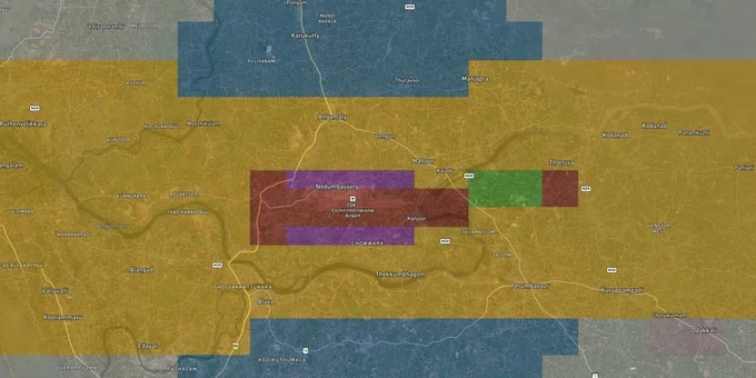
Kochi Air Funnel Zones Preview
Try the Kochi Air Funnel Zones on the map
Sign in once and explore the layer for a full day.
- No card details needed
- Find nearby verified lands for sale
Overview
Kochi Airport height restriction zone rules apply to every plot within 20 km of Cochin International Airport (IATA: COK, ICAO: VOCI), operated by Cochin International Airport Limited (CIAL) at Nedumbassery, about 25 km northeast of downtown Kochi. AAI has published a dedicated Colour Coded Zoning Map (CCZM) for Cochin Airport, prepared under GSR 751(E). Crucially, this CCZM explicitly excludes the jurisdiction of the Naval Airfield, Kochi. That means plots near INS Garuda face a second, independent set of defense authority restrictions on top of the AAI rules.
Why Kochi Has a Dual Jurisdiction Problem That Most Buyers Near Ernakulam Never Hear About
Kochi is uniquely complicated among Indian cities: two separate airfields operate here. CIAL at Nedumbassery handles commercial traffic, and INS Garuda, the Indian Navy's air station within Kochi city, operates on the southern side. AAI's published CCZM for Cochin airport states plainly that it covers only CIAL's obstacle limitation surfaces and does not include the jurisdiction of the Naval Airfield Kochi. Local authorities are directed to refer to defence authorities separately for any site falling within INS Garuda's jurisdiction.
This dual jurisdiction is the single most consequential trap for buyers in Ernakulam. A plot that clears the AAI CCZM for CIAL may still need a separate NOC from the local military authority because of INS Garuda's airspace. The AAI CCZM for Cochin uses the standard formula: permitted AGL height equals the CCZM Permissible Top Elevation (AMSL) minus your site's ground elevation. The table below shows how height limits shift across the main OLS zones around CIAL at Nedumbassery.
Zone
Distance Reference
Max Permitted Height
Approving Authority
Runway Strip (No-build)
0–500 m from runway edge
No construction
N/A
Inner Horizontal Surface
Up to 4 km from ARP
45 m AGL
AAI NOC mandatory
Airport Funnel (Approach path)
Along runway 27/09 approach
2% of distance from runway edge
AAI NOC mandatory
Conical Surface
4–8 km approx.
Increases 1 m per 20 m of distance
AAI NOC mandatory
Outer Horizontal Surface
Up to 15 km from ARP
Up to 300 m AMSL
AAI NOC mandatory
Peripheral Zone
15–20 km
No hard cap, monitored
AAI NOC mandatory
Naval Airfield Zone (INS Garuda)
Kochi city area
Separate, not in CCZM
Defence authorities
The CIAL runway 27/09 is 3,445 m long and oriented east-west. Its funnel zones extend toward Angamaly and Sreemoolanagaram in one direction and toward Kanjoor in the other. If your plot sits along either of those corridors, the funnel zone ceiling is the binding constraint, not the inner horizontal surface limit.
Nedumbassery, Angamaly and the Athani Corridor: Where the AAI Ceiling Bites Hardest and Where Metro Access Is Shifting Values
The panchayat areas of Nedumbassery, Sreemoolanagaram, and Kanjoor sit directly on or adjacent to the runway itself. These are the tightest-restricted localities in the Kochi metro area. Plots here are effectively inside the inner horizontal surface or funnel zone. Angamaly, about 5 km from the airport, is the first town along NH 544 where buyers expect to develop multi-floor residential or commercial buildings without airport friction; that expectation is often wrong for taller structures.
The table below maps the corridors most active in the Kochi land market against their primary restriction risk.
Corridor / Locality
Approx. Distance from CIAL ARP
Primary Zone Risk
Key Demand Driver
Nedumbassery
0-2 km
Inner horizontal surface / funnel zone
Airport employment, CIAL Aerotropolis
Sreemoolanagaram / Kanjoor
Adjacent to runway
Funnel zone: extreme restriction
Runway panchayat areas
Angamaly
4-6 km
Conical surface / funnel overlap
NH 544 connectivity, railway station
Aluva
10-12 km
Outer horizontal surface
Kochi Metro terminus, industrial base
Athani
8-10 km
Outer horizontal surface
Kochi Metro Phase III corridor 1
The most misread corridor is Athani. Kochi Metro Phase III proposes two corridors: Aluva to Kochi Airport via Athani (Corridor 1) and Athani to Angamaly (Corridor 2), with CIAL expected to fund part of a 3 km underground link at Nedumbassery. Brokers pitch Athani as a pure metro-appreciation play. It still sits within the 20 km NOC radius. Verify your CCZM grid and get the Permissible Top Elevation for the exact survey number before paying the advance.
One more factor specific to Kochi: CIAL is actively developing the aerotropolis on 202 hectares in Nedumbassery and nearby villages, including a Special Economic Zone, an IT Park, and an Aero City phase. The first phase of CIAL Aero Park was inaugurated in February 2026. Any commercial plot marketed near that zone carries both the premium of the aerotropolis narrative and the hard ceiling of AAI's funnel zone. The two do not cancel each other out.
Was this layer helpful?
Anything wrong, outdated, or missing we want to hear it.
For Land Owners & Agents
Looking to sell your land in Kerala?
I want to sell my land in Kerala
10:32
Plz share your Land's location - We will list it on 1acre map, for Free.
10:32

For Land Buyers
Browse all verified lands & plots in Kerala
Every listing goes through our Preliminary Verification Process.
More Layers in Kerala
See all 10 layers
Kannur Masterplan: AMRUT Zone Check and Land Use Guide
View Kannur Masterplan as a live map overlay – check any plot's land use zone for free on 1acre.in. Kannur City Master P...
Kollam AMRUT Masterplan: Zone Check and Land Use Guide
View Kollam Masterplan as a live map overlay – check any plot's land use zone for free on 1acre.in. Kollam City Masterpl...
Kozhikode City Masterplan 2040: AMRUT Zone Check and Land Use Guide
View Kozhikode Masterplan as a live map overlay – check any plot's land use zone for free on 1acre.in. Kozhikode masterp...
More Layers in Kerala
Kannur Masterplan: AMRUT Zone Check and Land Use Guide
View Kannur Masterplan as a live map overlay – check any plot's land use zone for free on 1acre.in. Kannur City Master P...
Kollam AMRUT Masterplan: Zone Check and Land Use Guide
View Kollam Masterplan as a live map overlay – check any plot's land use zone for free on 1acre.in. Kollam City Masterpl...
Kozhikode City Masterplan 2040: AMRUT Zone Check and Land Use Guide
View Kozhikode Masterplan as a live map overlay – check any plot's land use zone for free on 1acre.in. Kozhikode masterp...