Kollam AMRUT Masterplan: Zone Check and Land Use Guide
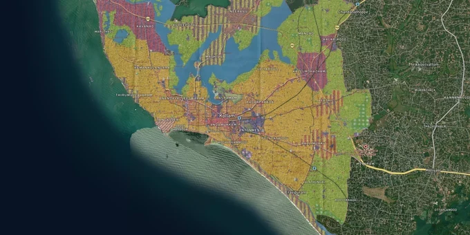
Kollam Masterplan Preview
Try the Kollam AMRUT Masterplan on the map
Sign in once and explore the layer for a full day.
- No card details needed
- Find nearby verified lands for sale
Overview
The Kollam City Masterplan 2041 is the operative land-use plan covering the entire 57.28 sq km jurisdiction of Kollam Municipal Corporation. Prepared under the AMRUT programme and given final government approval vide S.O.(Kai) No.1/2024/LSGD dated 11 January 2024, it is administered by the LSGD (Planning), Kollam. The plan defines over twenty distinct zones, from High Density Residential to Heritage Zone I and II, Conservation Zone, Eco Sensitive Areas, and CRZ-regulated waterfront parcels. Every plot in Kollam falls inside one of these categories, and the category decides what can be built, what requires special concurrence, and what is flatly prohibited.
Heritage and Conservation Zone traps unique to Kollam
Kollam's masterplan carries two zone categories that regularly cause buyers grief: Heritage Zone I and II, and the Conservation Zone. Heritage zones encircle historically significant precincts, including the Thangassery area on the southern waterfront. The plan explicitly retains Thangassery as a protected open space on account of its historical importance. Construction within a Heritage Zone requires Secretary-level concurrence, and additional alterations affecting the heritage character require sign-off from the Chief Town Planner of LSGD (Planning). What brokers rarely disclose is that the Heritage Zone classification is not always visible from the title documents alone.
Restricted Zone Categories Under Kollam AMRUT Masterplan 2041
The table below summarises the three most consequential restricted categories under the 2041 plan:
Zone
Permitted Use
Requires Conversion?
Commonly Misrepresented?
Heritage Zone I & II
Maintenance; heritage-consistent uses only
No conversion available; only Secretary + Chief Town Planner concurrence
Yes; sold as "residential" by agents
Conservation Zone
No new construction; existing lawful uses continue as non-conforming
Adjoining land must be re-verified against revenue records
Yes; shown as buildable agricultural land
Eco Sensitive Areas
No residential or commercial construction
Not applicable
Frequently mistaken for open-space or green-belt plots
One fact no government portal currently displays prominently: if your plot sits inside the Conservation Zone or Heritage Zone on the masterplan map but the revenue records show it as dry land (purayidam), the Secretary can, with District Town Planner concurrence, permit uses applicable to theadjacentzone instead. You must apply in writing. The broker will not do this for you.
Kadappakkada, Neendakara, and the Ashtamudi waterfront: where zoning determines value
Kollam's commercial sub-centres, running outward from Chinnakkada through Ramankulangara, Pallimukku, Neendakara, and Kadappakkada, have been designated as mixed-use corridors since the city's earlier development plans and that designation has been carried forward in the 2041 masterplan. These are the corridors with the clearest commercial development rights. The Ashtamudi waterfront is a different story. Kollam topped Kerala's CRZ violation list with 4,868 documented violations identified by the Coastal District Committee, and 184 islands in the Ashtamudi system have been brought under CRZ regime. Any land within 500 m of the high tide line along the Ashtamudi shore or the Neendakara coast falls under the Coastal Regulation Zone.
This table maps the broad risk profile of Kollam's key corridors under the 2041 plan and CRZ:
Corridor / Locality
Zone (Masterplan 2041)
Growth Driver
Known Risk
Chinnakkada–Pallimukku
Commercial Zone
Core city; road widening to 20m
Road-widening setback affects frontage plots
Ramankulangara–Kadappakkada
Mixed Commercial & Residential
Peripheral commercial expansion
Verify zone boundary; edge parcels slip into residential
Neendakara
Industrial / Transportation Zone
Fisheries port; existing industry
Industrial zone; residential use is restricted
Ashtamudi waterfront
Water bodies / Buffer Water Bodies
Tourism; backwater proximity
CRZ restrictions; no construction in buffer water bodies zone
Thangassery
Heritage Zone
Historical significance; tourism
No new construction rights; Heritage Zone I or II
The most misread corridor is Neendakara. It appears on price-comparison sites as a waterfront residential area, but significant portions fall under the Industrial Zone or Transportation Zone in the masterplan, where residential use requires special concurrence and is not a matter of right.
Was this layer helpful?
Anything wrong, outdated, or missing we want to hear it.
For Land Owners & Agents
Looking to sell your land in Kerala?
I want to sell my land in Kerala
10:32
Plz share your Land's location - We will list it on 1acre map, for Free.
10:32

For Land Buyers
Browse all verified lands & plots in Kerala
Every listing goes through our Preliminary Verification Process.
More Layers in Kerala
See all 10 layers
Kannur Masterplan: AMRUT Zone Check and Land Use Guide
View Kannur Masterplan as a live map overlay – check any plot's land use zone for free on 1acre.in. Kannur City Master P...
Kozhikode City Masterplan 2040: AMRUT Zone Check and Land Use Guide
View Kozhikode Masterplan as a live map overlay – check any plot's land use zone for free on 1acre.in. Kozhikode masterp...
Thiruvananthapuram Masterplan 2040: TRIDA Zone Check and Land Use Guide
View Thiruvananthapuram Masterplan as a live map overlay – check any plot's land use zone for free on 1acre.in. Thiruvan...
More Layers in Kerala
Kannur Masterplan: AMRUT Zone Check and Land Use Guide
View Kannur Masterplan as a live map overlay – check any plot's land use zone for free on 1acre.in. Kannur City Master P...
Kozhikode City Masterplan 2040: AMRUT Zone Check and Land Use Guide
View Kozhikode Masterplan as a live map overlay – check any plot's land use zone for free on 1acre.in. Kozhikode masterp...
Thiruvananthapuram Masterplan 2040: TRIDA Zone Check and Land Use Guide
View Thiruvananthapuram Masterplan as a live map overlay – check any plot's land use zone for free on 1acre.in. Thiruvan...