Thiruvananthapuram Masterplan 2040: TRIDA Zone Check and Land Use Guide
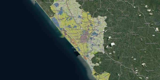
Thiruvananthapuram Masterplan Preview
Try the Thiruvananthapuram Masterplan 2040 on the map
Sign in once and explore the layer for a full day.
- No card details needed
- Find nearby verified lands for sale
Overview
Thiruvananthapuram Master Plan 2040 is the land use framework for the 296 sq km TRIDA jurisdiction, covering the Corporation and five surrounding panchayats: Vilappil, Vilavoorkkal, Pallichal, Kalliyoor, and Venganoor. Approved by the Corporation Council in November 2022 under the AMRUT scheme, the plan divides the city into 25 sub-zones spanning residential, commercial, IT, industrial, tourism, heritage, and special development categories. CRZ overlays, a draft-versus-notified status gap, and two TOD corridors along NH-66 (formerly NH-47) and the NH bypass make this the most consequential zone map to check before any plot purchase.
Thiruvananthapuram Master Plan 2040 Plot Zone Risks: Draft Status and CRZ Overlap
The Thiruvananthapuram Master Plan 2040 was approved by the Corporation Council in November 2022 but has not been gazette notified by the Kerala state government. The operative document is the Sanctioned Master Plan for Thiruvananthapuram-2040 (AMRUT) on townplanning.kerala.gov.in. The TMC's November 2022 draft is a separate document pending Kerala state gazette notification — distinct from the AMRUT-sanctioned plan, available alongside its Gazette order, Proposed Land Use Map, Proposed Transportation Map, and Zoning Regulation at townplanning.kerala.gov.in. Zone classifications in the 2040 draft, including special development zone boundaries and TOD corridor NH bypass bands, carry no statutory force until the state issues formal notification. Any broker presenting the draft map as legally binding is working with unconfirmed data.
The second trap targets plots near the coast. The Kerala Coastal Zone Management Authority documented 14 major CRZ violations in Thiruvananthapuram district, the second-highest in Kerala after Ernakulam's 24. A plot inside a CRZ-IIIA area falls within a 50-metre No Development Zone from the High Tide Line. CRZ-IIIB areas extend that restriction to 200 metres. No building permit is valid without prior CRZ clearance from the KCZMA, regardless of what the 2040 plan's zone map shows for the same parcel. The CZMA 2019 maps for Thiruvananthapuram cover 10 grid sheets (KL-01 to KL-10) at keralaczma.gov.in. Verify your survey number on them before signing anything.
Two additional risks apply in the panchayat fringes. All five panchayats under TRIDA jurisdiction are included in the zone map but may be governed by Kerala Panchayat Building Rules rather than Corporation regulations. Confirm which set of building rules applies to your plot before purchase. This determines permitted FAR, setback distances, and the approval authority.
Primary Risk Traps Under the TRIDA Masterplan 2040
The table below identifies the three primary traps and the verification each requires.
Regulatory Trap
What Makes It Thiruvananthapuram-Specific
Verification Step
Draft, not gazette notified
Corporation approved Nov 2022; state notification pending
Operative AMRUT zoning order at townplanning.kerala.gov.in
CRZ coastal overlap
14 KCZMA-documented violations (per KCZMA report; verify count); 10 grid maps (KL-01 to KL-10)
CZMA 2019 maps at keralaczma.gov.in
TOD band along NH-66 (formerly NH-47) and NH bypass
250m bands carry higher FAR but stricter mixed-use compliance
Confirm TOD demarcation with TRIDA before any plot near national highways
If a broker cannot produce both the operative AMRUT zoning order and a clean KCZMA grid map for your survey number, do not proceed.
Kazhakuttam to Vizhinjam: How TMC/TRIDA Zones and Infrastructure Status Affect Plots
The Thiruvananthapuram Master Plan 2040 concentrates its highest-intensity development zones along two axes: the NH bypass corridor running north through Kazhakuttam toward Technopark, and the southern belt from Kovalam toward Vizhinjam International Seaport. Technopark already employs more than 56,000 professionals (per Technopark/Kerala IT Mission), and the 2040 plan designates the NH bypass as a TOD zone with 250-metre development bands on each side, making the Kazhakuttam-Menamkulam stretch the most regulation-backed land market in the city. The Thonnakkal-Sasthavattom belt, positioned between Technopark Phase 4 and Technocity, is the speculative middle tier: demand is real, but delivery timelines are less certain than the established northern IT zone. The heritage zone covering Fort and Kowdiar is a third category altogether, where new commercial construction is heavily restricted and these areas should not be treated as investment corridors.
The table below ranks the active corridors by investment readiness, not current price.
Corridor
Zone Type (2040 Plan)
Key Demand Driver
Regulatory Readiness
Known Risk
Kazhakuttam, Menamkulam
IT sector zone, NH bypass TOD
Technopark (56,000+ employees), NH 66
High
Limited large parcels; prices elevated
Thonnakkal, Sasthavattom
Adjacent to Special Zone C
Technopark Phase 4, Technocity, Science Park
Medium
Development timelines uncertain
Kovalam, Vizhinjam
Tourism zone, southern ring road
Vizhinjam International Seaport
Medium
Active land acquisition; CRZ on coastal plots
Peroorkada, Enchakkal
Major mobility hub (2040 plan)
Intercity bus terminal hub
Medium
Older residential stock; limited upside
Kowdiar, Fort
Heritage zone
Government and institutional precinct
Low
Heritage conservation limits new construction
The most misread corridor is Vizhinjam. Inquiry volumes have risen along Kovalam and Balaramapuram since seaport construction began, and the Outer Ring Road (NH-866) — a 77.8 km project comprising the Northern Ring (29.25 km, Navaikulam–Thekkada), the Southern Ring (47.9 km, Mangalapuram–Vizhinjam), and a 13.25 km Thekkada–Mangalapuram link will improve connectivity once complete. The problem is that the southern ring is still in active land acquisition. The state has committed Rs 1,629 crore (KIIFB share of land acquisition + service roads) for the outer ring road linked to the seaport, and that commitment is firm but so is the risk of compulsory acquisition at government-notified rates for plots within the alignment. In the Fort and Kowdiar heritage zone, new construction requires approvals beyond standard building permits, and commercial development is severely constrained by the conservation overlay. Confirm the southern ring alignment at the Thiruvananthapuram Collector's land acquisition notice portal at trivandrum.nic.in before committing funds to any Kovalam or Vizhinjam parcel.
Was this layer helpful?
Anything wrong, outdated, or missing we want to hear it.
For Land Owners & Agents
Looking to sell your land in Kerala?
I want to sell my land in Kerala
10:32
Plz share your Land's location - We will list it on 1acre map, for Free.
10:32

For Land Buyers
Browse all verified lands & plots in Kerala
Every listing goes through our Preliminary Verification Process.
More Layers in Kerala
See all 10 layers
Kannur Masterplan: AMRUT Zone Check and Land Use Guide
View Kannur Masterplan as a live map overlay – check any plot's land use zone for free on 1acre.in. Kannur City Master P...
Kollam AMRUT Masterplan: Zone Check and Land Use Guide
View Kollam Masterplan as a live map overlay – check any plot's land use zone for free on 1acre.in. Kollam City Masterpl...
Kozhikode City Masterplan 2040: AMRUT Zone Check and Land Use Guide
View Kozhikode Masterplan as a live map overlay – check any plot's land use zone for free on 1acre.in. Kozhikode masterp...
More Layers in Kerala
Kannur Masterplan: AMRUT Zone Check and Land Use Guide
View Kannur Masterplan as a live map overlay – check any plot's land use zone for free on 1acre.in. Kannur City Master P...
Kollam AMRUT Masterplan: Zone Check and Land Use Guide
View Kollam Masterplan as a live map overlay – check any plot's land use zone for free on 1acre.in. Kollam City Masterpl...
Kozhikode City Masterplan 2040: AMRUT Zone Check and Land Use Guide
View Kozhikode Masterplan as a live map overlay – check any plot's land use zone for free on 1acre.in. Kozhikode masterp...