Hyderabad HMDA Masterplan: Zone Check and Land Use Guide
Hyderabad Masterplan Preview
Try the Hyderabad Masterplan on the map
Sign in once and explore the layer for a full day.
- No card details needed
- Find nearby verified lands for sale
Overview
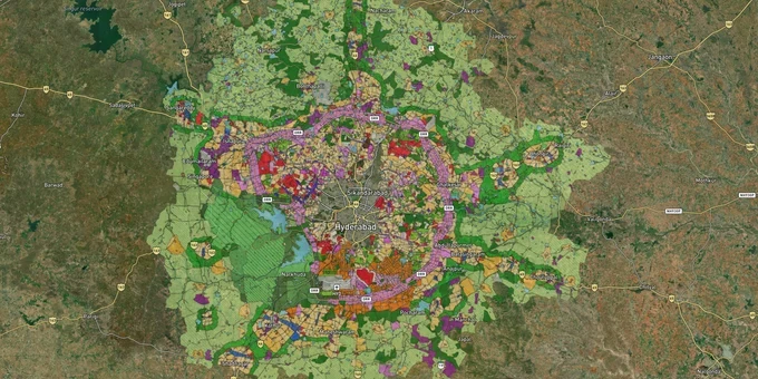
The Hyderabad masterplan zone check is the foundational due diligence step for any property or land transaction within the Hyderabad Metropolitan Region. The HMDA Master Plan 2031, notified by the Hyderabad Metropolitan Development Authority in 2013 and covering 5,965 sq km across 55 mandals in five pre-reorganization districts (now seven districts post-Telangana district reorganization; expanded to 11 districts via G.O. Ms. No. 68 in March 2025), divides the entire region into 12 defined land-use zones. In March 2025, the Government of Telangana issued G.O. Ms. No. 68 extending HMDA's jurisdiction to 10,472.723 sq km across 11 districts, bringing the Regional Ring Road corridor under HMDA planning control. This page covers the zone system, the GP layout trap that has locked thousands of buyers, and which corridors the masterplan actively supports for growth.The LP Number Test: Why the HMDA Masterplan Zone Must Match the Layout Approval
Hyderabad's most prevalent land fraud pattern is the sale of Gram Panchayat (GP) layouts inside HMDA jurisdiction, falsely marketed as "HMDA approved." Within HMDA limits, only the Metropolitan Development Authority can sanction layout plans. A GP does not hold that power. Unauthorised GP layouts in Rangareddy, Medak, and Mahbubnagar districts are now listed on HMDA's website, and as of 2024 the Telangana government has directed Sub-Registrar Offices to stop registrations on these layouts. A buyer who has already paid into such a layout faces blocked registration, no bank loan eligibility, and, in cases where Section 23 of the HMDA Act 2008 is applied, the possibility of the investment being auctioned.
Every legitimate HMDA layout carries a Layout Permission (LP) number. Buyers who see "HMDA approved" on a brochure but cannot find the LP number on the official HMDA portal have purchased nothing but a claim. Cross-reference the seller's name and survey number on the Bhu Bharati portal (formerly Dharani) for encumbrance history and ownership verification. The masterplan zone also governs what activity the land is legally permitted for. A Change of Land Use (CLU) is required whenever the intended activity differs from the zone designation, and CLU applications route exclusively through HMDA, not through TG-bPASS (tgbpass.telangana.gov.in), which handles other building and layout permissions from April 2024.
HMDA Master Plan 2031 Zone Classification: What Each Zone Means for Buyers
The table below maps the 12 HMDA Master Plan 2031 land-use zones to their primary permitted use and key construction constraint.
Zone
Permitted Principal Use
Residential Construction Permitted?
Key Constraint
R1
Residential (Growth Corridor-contiguous)
Yes
Follows road and zone plan; higher density allowed
R2
Residential (Non-contiguous urban areas)
Yes
Similar to R1; non-growth corridor
R3
Residential (Urban Centres)
Yes
Same as R1/R2; LPG centres prohibited
R4
Residential (Rural settlements / Gramkantham)
Limited
Natural expansion only; not for plotted development
Commercial
Shops, offices, mixed-use
Ancillary only
Full commercial activity permitted
Manufacturing
Industrial and work centres
No
HADA norms apply near airport
Peri-Urban
Transitional between urban and rural
Limited
Max 25% of land; residential ht. limit 18 m; commercial 15 m
Agricultural
Farming and livestock
No without CLU
CLU required for any non-agricultural use
Water Bodies
Lakes, rivers, tanks, kuntas
No construction in FTL
Buffer zone restrictions apply (30 m or 9 m)
Forest
Greenery and conservation
Prohibited
Clearance from government required
Recreation and Open Space
Parks, playgrounds
Prohibited for buildings
Entertainment use only
Public and Semi-Public
Schools, hospitals, civic use
No private residential
Institutional use only
Buyers who invest in Agricultural or Peri-Urban zone land expecting R1/R2 residential permissions will face a CLU rejection. The zone on the masterplan map and the zone stated in the developer's layout plan must match exactly before any money changes hands.
Corridors Where the HMDA Masterplan Zone is Actively Shaping Land Value
The HMDA masterplan zone has created clear winners and high-risk pockets across the metropolitan region. Properties in zones that align with road corridors and the ORR growth belt are drawing institutional-grade demand; land in Agricultural or Peri-Urban zones near those same roads is being sold speculatively with no legal basis for the promised residential use.
Kokapet, classified under HMDA's commercial and residential zones within the ORR corridor, reached approximately ₹10,350 per sq ft in Q1 2025 for residential apartments, driven by the Neopolis SEZ and IT demand. Adibatla and Maheshwaram in Rangareddy district are zoned for manufacturing and residential mixed use under the masterplan, with demand supported by Future City planning and aerospace park development; prices in 2025 range between ₹15,000 and ₹40,000 per sq yard. Shamshabad, near Rajiv Gandhi International Airport, sits under the HADA master plan and benefits from airport-driven logistics and residential growth at ₹30,000 to ₹70,000 per sq yard. The preliminary RRR notification issued in August 2025 covers 33 mandals and 163 villages across eight districts; land in those corridors is early-stage and speculative, but the 354 km alignment, planned at 100 m width with 12 radial connector roads, is documented.
The table below maps active growth corridors to their dominant HMDA zone and primary risk for buyers.
Corridor
Dominant HMDA 2031 Zone
Growth Driver
Key Risk
Kokapet / Financial District
Commercial + R1 Residential
IT SEZ, ORR corridor
Premium pricing; FTL lake buffers in adjacent parcels
Adibatla / Maheshwaram
Manufacturing + Residential
Future City, aerospace park
Agricultural pockets sold as residential
Shamshabad
HADA zone (airport-specific)
Airport, logistics
Height restrictions from HADA apply
Kompally / Shamirpet
R2 / Peri-Urban
NH44 corridor, north growth
Peri-urban zone limits construction to 25% coverage
RRR alignment corridor
Under preparation / no final plan
354 km expressway, preliminary notification 2025
No approved masterplan zone yet; speculative
Shadnagar / Tukkuguda
Agricultural + R4 fringe
Southern ORR entry, lower prices
CLU required for residential use
The most misunderstood corridor is the RRR belt. HMDA issued a preliminary notification in September 2025 covering survey numbers in eight districts, with a public feedback deadline of 15 September 2025. That notification is for alignment purposes, not a land-use zone grant. Buying agricultural land adjacent to the proposed RRR and assuming residential zone reclassification will follow is speculative. The HMDA Master Plan 2050 (succeeding the earlier 2041 draft effort), which will govern the expanded RRR corridor, is still in preparation. The Comprehensive Mobility Plan 2050 component is being developed by LEA Associates South Asia Pvt. Ltd.
Was this layer helpful?
Anything wrong, outdated, or missing we want to hear it.
For Land Owners & Agents
Looking to sell your land in Telangana?
I want to sell my land in Hyderabad Outer
10:32
Plz share your Land's location - We will list it on 1acre map, for Free.
10:32

For Land Buyers
Browse all verified lands & plots in Telangana
Every listing goes through our Preliminary Verification Process.
More Layers in Telangana
See all 21 layers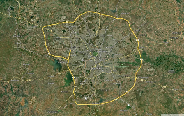
Hyderabad Outer Ring Road (ORR)
View the Hyderabad ORR Growth Corridor on a live map overlay - check HMDA layout approval, zone status and acquisition r...
Hyderabad Regional Ring Road (RRR): Route Map and Land Impact
View RRR alignment as a live map overlay – check land acquisition risk and plot proximity free on 1acre.in. Hyderabad Re...
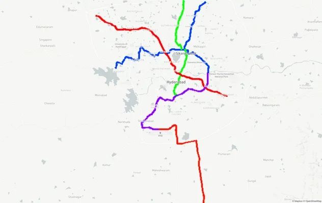
Hyderabad Metro Lines: Route Map and Corridor Impact
View Metro Lines route as a live map overlay – check metro corridor impact on plots free on 1acre.in. Hyderabad metro la...
More Layers in Telangana
Hyderabad Outer Ring Road (ORR)
View the Hyderabad ORR Growth Corridor on a live map overlay - check HMDA layout approval, zone status and acquisition r...
Hyderabad Regional Ring Road (RRR): Route Map and Land Impact
View RRR alignment as a live map overlay – check land acquisition risk and plot proximity free on 1acre.in. Hyderabad Re...
Hyderabad Metro Lines: Route Map and Corridor Impact
View Metro Lines route as a live map overlay – check metro corridor impact on plots free on 1acre.in. Hyderabad metro la...