Hyderabad Air Funnel Zones: Building Height Restrictions
Hyderabad Air Funnel Zones Preview
Try the Hyderabad Air Funnel Zones on the map
Sign in once and explore the layer for a full day.
- No card details needed
- Find nearby verified lands for sale
Overview
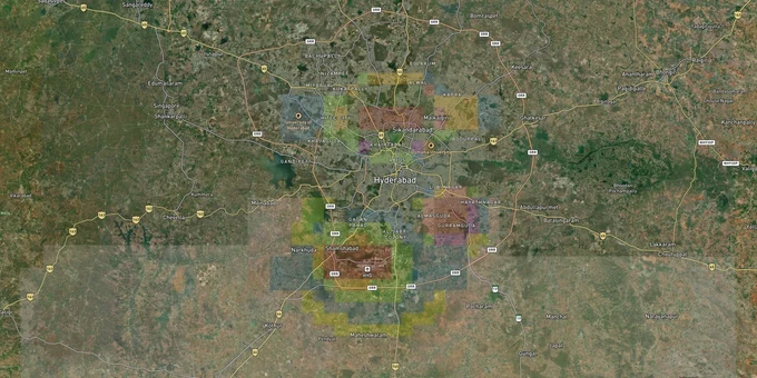
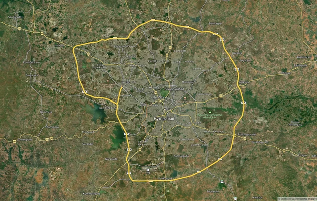
Hyderabad airport funnel zone restrictions affect every parcel within 56 km of Rajiv Gandhi International Airport (RGIA, IATA: HYD, ICAO: VOHS) at Shamshabad, covering the entire HADA area of 458 sq km across 70 revenue villages in Ranga Reddy District. Under the Ministry of Civil Aviation Height Restriction Rules 2015, no structure within 56 km of RGIA's Aerodrome Reference Point can be built without a No Objection Certificate (NOC) from the Airports Authority of India (RGIA is an IFR-rated airport under International Civil Aviation Organization (ICAO) classification — the 20 km limit applies only to VFR airports). The AAI has published a Colour Coded Zoning Map (CCZM) specifically for Hyderabad-Shamshabad to show Permissible Top Elevation for each grid. This page explains zone-by-zone height caps, the corridors where land still offers development potential, and the exact checks your lawyer must run before any land transaction in this area.
Height Restriction Traps That Kill Development Rights in the HADA Zone
Most buyers focus on title and miss the bigger problem: the air funnel itself. In Hyderabad, the funnel zone runs east-west aligned with RGIA's runways and extends outward roughly 34.5 km from the airport. Inside this corridor, permitted building height equals just 2% of your distance from the runway edge. Put plainly, a plot 1,000 metres from the runway end can support a structure of only 20 metres, regardless of what the HADA master plan zone allows for that land use.
The former HADA area (now administered by the Hyderabad Metropolitan Development Authority (HMDA) since 2008) has a master plan classifying land across ten categories, but the funnel cuts across several of them. The Institutional and Special Reservation Zone, for example, permits G+4 construction only in areas that do not fall within the direct flight path. The Recreational Zone caps everything at 10 metres regardless of location. Even in High Rise Promotion Zones (HRPZ), a plot inside the funnel corridor will face a hard height ceiling set by the ICAO Annex 14 Obstacle Limitation Surfaces calculation, not by the HADA zone code alone.
This table shows the height rules that apply across key surface types near RGIA:
Surface Type
Distance from Runway
Max Permitted Height
NOC Authority
Approach / Funnel Surface
0–500 m (runway strip)
No construction
AAI
Inner Horizontal Surface
Up to 4 km from aerodrome
45 m
AAI via NOCAS
Outer Horizontal Surface
4–15 km
Increases 1 m per 20 m of distance, max 300 m
AAI via NOCAS / CCZM
Peripheral Zone
15–20 km
No height cap, NOC still required
AAI
Begumpet Airport compounds this problem. Commercial flights moved to RGIA in 2008, but the Ministry of Civil Aviation has confirmed it will not lift funnel restrictions around Begumpet because VIP, helicopter, and defence operations continue there. Colonies in Mahendra Hills, Shantiniketan, and Balamrai require an NOC for even a ground-floor structure on high-altitude plots. AAI's aerodrome safeguarding team issued notices to Anna Nagar residents in Secunderabad Cantonment as recently as September 2025, demanding height clearance documentation for existing buildings built over decades.
Before any land transaction within the HADA boundary, ask the seller for the survey number and run it through the AAI NOCAS portal at nocas2.aai.aero. If the Permissible Top Elevation on the CCZM is lower than what the broker is promising, that gap is your loss.
Corridors Around Shamshabad: Where the Funnel Lifts and Land Becomes Viable
Not every parcel near the airport is a dead end. The opportunity lies in understanding exactly where the HADA zone ends and the funnel height restrictions ease.
Shamshabad itself has height restrictions baked into every title. Development there is real, but vertical ambiguity is constant. The genuinely freer investment zone starts beyond the HADA boundary, particularly once you pass ORR Exit 16 southward on NH-44. The 13-km stretch from Exit 16 toward Thimmapur is constrained by both the HADA zone and GO 111 (on the right flank protecting Himayat Sagar catchment area). Once you clear Thimmapur, the industrial-residential split becomes cleaner.
This table maps the key corridors by development character and funnel exposure:
Corridor / Locality
Zone Classification
Growth Driver
Funnel / Height Risk
Shamshabad (core HADA area)
HADA mixed HRPZ / Work Centre / Institutional
RGIA, GMR Aerocity (1,500 acres), NH-44
High full HADA and CCZM rules apply
Tukkuguda
HADA boundary fringe
Telangana E-City (Fab City), ORR Exit 14
Moderate verify CCZM grid before building
Thimmapur / Palamakula
HADA transition zone
Industrial corridor, logistics parks
Moderate HADA limit applies, confirm boundary
Kothur (beyond HADA limits)
Outside HADA, beyond funnel zone
Industrial SEZ, Natco Pharma, Amazon warehouse, NH-44
Low outside HADA, standard HMDA rules apply
Shadnagar
Outside HADA
Microsoft data centre, MMTS extension, ISRO NRSC
Low check regional ring road alignment
The most misread corridor is Kothur. Because it sits 16 km from RGIA and outside HADA limits, it avoids both the HADA development regulations and the strictest funnel height caps. That does not mean it is unrestricted. Standard HMDA zoning, Telangana State Building Permission Approval and Self-certification System (TS-bPASS) approvals, and GO 111 checks on the right side of NH-44 still apply. However, for buyers who want airport-adjacent appreciation without the funnel ceiling overhead, Kothur and Shadnagar are where the arithmetic works.
Was this layer helpful?
Anything wrong, outdated, or missing we want to hear it.
For Land Owners & Agents
Looking to sell your land in Telangana?
I want to sell my land in Telangana
10:32
Plz share your Land's location - We will list it on 1acre map, for Free.
10:32

For Land Buyers
Browse all verified lands & plots in Telangana
Every listing goes through our Preliminary Verification Process.
More Layers in Telangana
See all 22 layers
Hyderabad HMDA Masterplan: Zone Check and Land Use Guide
View Hyderabad Masterplan as a live map overlay – check any plot's land use zone for free on 1acre.in. Hyderabad masterp...
Hyderabad Outer Ring Road (ORR)
View the Hyderabad ORR Growth Corridor on a live map overlay - check HMDA layout approval, zone status and acquisition r...
Hyderabad Regional Ring Road (RRR): Route Map and Land Impact
View RRR alignment as a live map overlay – check land acquisition risk and plot proximity free on 1acre.in. Hyderabad Re...
More Layers in Telangana
Hyderabad HMDA Masterplan: Zone Check and Land Use Guide
View Hyderabad Masterplan as a live map overlay – check any plot's land use zone for free on 1acre.in. Hyderabad masterp...
Hyderabad Outer Ring Road (ORR)
View the Hyderabad ORR Growth Corridor on a live map overlay - check HMDA layout approval, zone status and acquisition r...
Hyderabad Regional Ring Road (RRR): Route Map and Land Impact
View RRR alignment as a live map overlay – check land acquisition risk and plot proximity free on 1acre.in. Hyderabad Re...