Warangal Air Funnel Zones: Building Height Restrictions

Warangal Air Funnel Zones Preview
Try the Warangal Air Funnel Zones on the map
Sign in once and explore the layer for a full day.
- No card details needed
- Find nearby verified lands for sale
Overview
The Warangal airport height restriction zone covers land around Mamnoor Airport (ICAO: VOWA), currently under redevelopment with a sanctioned ₹850 crore project for a 2,500-metre runway and new terminal. This layer, based on AAI Colour Coded Zoning Maps data, shows the Obstacle Limitation Surfaces (OLS) that cap building heights across a 20 km radius from the Aerodrome Reference Point. Anyone buying land near Mamnoor for construction must check these zones before signing. The 1acre premium layer maps these restrictions against actual survey numbers so you know exactly what you are walking into.
AAI Height Rules in Warangal: What the CCZM Actually Restricts
The air funnel zone is the most punishing zone in this layer, and most buyers do not know it exists until a building permit gets blocked. Aligned directly with Mamnoor's runway ends, this zone enforces a hard formula: permitted building height equals 2% of your distance from the runway edge. A plot 1,000 metres from the runway end is capped at just 20 metres AGL, roughly 5 to 6 floors.
The Ministry of Civil Aviation's Height Restrictions for Safeguarding of Aircraft Operations Rules, 2015 (G.S.R. 751(E)) make the position clear. No structure of any kind can be built within 20 km of the Aerodrome Reference Point without a No Objection Certificate from AAI, regardless of height or building type. This is not a discretionary check: it applies to homes, warehouses, towers, transmission lines, and even trees if they are likely to breach the permitted surface.
The table below shows how different OLS zones translate into real building limits around Mamnoor.
Zone
Location
Height Limit (approx.)
NOC Required?
Air Funnel (Approach/Take-off Climb)
Directly along runway axis
2% of distance from runway end (e.g. 20m at 1 km)
Yes, mandatory
Inner Horizontal Surface
~4 km radius from ARP
~45 m AGL
Yes, mandatory
Conical Surface
4–20 km from ARP
Rises gradually, 45–100 m+
Yes, mandatory
Peripheral Zone (7 km from ARP)
Mid-distance ring
Up to 140 m before AAI approval needed in Warangal
Yes, if exceeding threshold
At 7 km from Mamnoor, buildings only need AAI approval above 140 metres, which is more permissive than metros like Amritsar. But that figure applies to the peripheral ring only. Inside the funnel path, the ceiling is far lower and non-negotiable. Violations are dealt with under the Aircraft (Demolition of Obstructions) Rules, 1994, which means compulsory demolition, not just a fine.
Apply for height clearance through NOCAS (nocas2.aai.aero) before you approach the local body for any building permit. If the CCZM permissible elevation covers your planned height, local authorities can clear you without a direct AAI application. If it does not, you must go through AAI first. Starting construction without clearance is not a paperwork oversight. It is a statutory violation.
Mamnoor Airport and Land Prices: The Corridors Worth Watching
Mamnoor is not an operational airport yet, but the money has started moving. In August 2025, farmers in Gunturpally were demanding ₹4 crore per acre after the government offered ₹1.20 crore. Before the redevelopment announcement, agricultural land near Mamnoor was valued at roughly ₹1 crore per acre. After it, prices doubled to ₹2 crore per acre in surrounding villages. That gap tells you two things: local belief in the project is high, and early positions are already expensive.
The table below maps the corridors where this layer has the sharpest effect on land use and value.
Corridor / Village
Distance from ARP
Current Signal
Key Risk
Nakkalapally, Gadipally, Gunturpally
0–2 km
Land acquisition ongoing (G.O. M.S. No. 36, 2023)
Government acquisition at below-market rates
Mamnoor main village
1–3 km
Inside funnel zone or inner horizontal surface
Severe height caps on any construction
Bollikunta / Inavolu
5–8 km
Plots marketed on NH-563 proximity, 6 km from airport
Outside funnel, but NOC still mandatory
Madikonda / Hanamkonda highway belt
8–12 km
IT SEZ proximity adds a second value driver
In peripheral zone, 140 m threshold applies
The most misunderstood corridor is the 1–5 km ring around Mamnoor village itself. Sellers market it as the prime airport-proximity zone. From an investment standpoint the proximity is real, but what they do not say is that plots in this ring sit squarely inside the inner horizontal surface or funnel zone. You can own the land. You cannot build freely on it. For warehousing, low-rise logistics, or agricultural use, this zone works. For residential plots above 3 or 4 floors, it does not, and no local builder can override AAI.
The Kakatiya Mega Textile Park proposal and NIT Warangal's presence give the wider Warangal land market more than one growth lever beyond the airport. Land with road access to NH-563 or the Warangal Outer Ring Road, sitting outside the inner restriction zones, has the cleanest risk profile for buyers who want to build.
Was this layer helpful?
Anything wrong, outdated, or missing we want to hear it.
For Land Owners & Agents
Looking to sell your land in Telangana?
I want to sell my land in Telangana
10:32
Plz share your Land's location - We will list it on 1acre map, for Free.
10:32

For Land Buyers
Browse all verified lands & plots in Telangana
Every listing goes through our Preliminary Verification Process.
More Layers in Telangana
See all 22 layers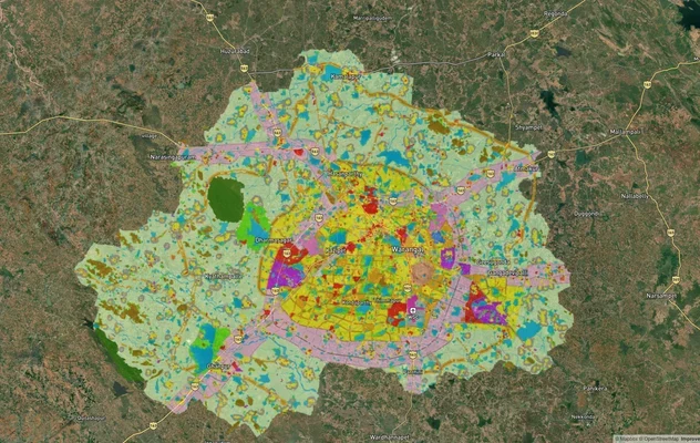
Warangal Masterplan: WUDA Zone Check and Land Use Guide
View Warangal Masterplan as a live map overlay – check any plot's land use zone for free on 1acre.in. Warangal KUDA mast...

Warangal - Khammam Expressway
View Warangal - Khammam Expressway alignment as a live map overlay – check land acquisition risk and plot proximity free...
Warangal Highway - NH-163
View the Warangal Highway - NH-163 corridor on a live map overlay – check zoning, approvals and acquisition risk free on...
More Layers in Telangana
Warangal Masterplan: WUDA Zone Check and Land Use Guide
View Warangal Masterplan as a live map overlay – check any plot's land use zone for free on 1acre.in. Warangal KUDA mast...
Warangal - Khammam Expressway
View Warangal - Khammam Expressway alignment as a live map overlay – check land acquisition risk and plot proximity free...
Warangal Highway - NH-163
View the Warangal Highway - NH-163 corridor on a live map overlay – check zoning, approvals and acquisition risk free on...