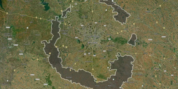
HMDA Extended Area (G.O. 68, 2025): 1,355 Villages Across 11 Districts
Hmda Extended Area Preview
Try the Hyderabad Extended Area (G.O. 68, 2025) on the map
Sign in once and explore the layer for a full day.
- No card details needed
- Find nearby verified lands for sale
Overview
The HMDA Extended Area is Hyderabad's largest planning shake-up in over a decade. G.O. Ms. No. 68 MA & UD, issued on 12 March 2025, brought 1,355 revenue villages across 104 mandals in eleven districts under the Hyderabad Metropolitan Development Authority, stretching its jurisdiction to 10,472 sq km up to the proposed Regional Ring Road. Every land transaction in this expanded belt now falls under HMDA rules, not gram panchayat norms. This page covers what that means for buyers: which zone checks apply, where the fraud traps are, and which corridors are seeing real movement. G.O. 68 also excluded 36 villages from HMR for transfer to FCDA (see /map-layers/telangana/future_city for the corresponding zone).
Panchayat Layout Fraud Inside HMDA Extended Area Limits
The single biggest trap in HMDA Extended Area land buying is the panchayat layout. Gram panchayat layouts are not legally permitted for sale or registration inside HMDA jurisdiction - this rule has been in force since 2020, and the current state government began enforcing it strictly in late 2024. In Ranga Reddy district alone, registrations of 348 such ventures were blocked by sub-registrar offices after the list of unauthorised layouts was uploaded to the HMDA website.
Fraudsters exploit two specific gaps. First, they present a valid-looking LP number (Layout Permission number) without buyers ever verifying it. LP numbers are unique to each HMDA-approved layout; a broker can paste any number on a brochure. Second, agricultural land sold as "NA-converted" in the extended area often has no conversion certificate to show. Without that, any construction is illegal regardless of what the sale deed says.
The table below shows the four most common document fraud patterns in this region, drawn from field reports and regulatory actions:
Fraud Type
What Sellers Claim
How to Verify
Fake LP number
"HMDA approved" layout
Cross-check LP number on hmda.gov.in under Online Services
Panchayat layout sold as HMDA
GP patta shown as approval
Check HMDA unauthorised layout list: Rangareddy, Medak, Mahbubnagar
Agricultural land without NA
Verbal CLU assurance
Demand written conversion certificate before any advance
Survey number mismatch
Brochure vs. registration deed
Verify survey number against Bhu Bharati portal (formerly Dharani) ownership records
If the LP number in a developer's brochure does not appear on the HMDA website under that mandal, that deal is dead. All building permissions and layout approvals within gram panchayats under HMDA limits now process exclusively through TG-bPASS; any seller claiming panchayat authority bypasses this entirely and is selling you an unregisterable asset.
Shamshabad, Chevella, and Shadnagar: Where This Layer Changes the Math
The RRR corridor is where the HMDA Extended Area expansion has the sharpest impact on land values. Three micro-markets stand out for buyers doing HMDA Extended Area plot zone checks right now.
Shamshabad sits within HMDA's core zone in the former HADA (Hyderabad Airport Development Authority) jurisdiction, which was merged into HMDA in 2008 (G.O.Ms.No.572 MA dt. 25.08.2008). The legacy HADA Master Plan zone regulations remain in force as a special zone within HMDA MP 2031, and AAI/DGCA air-funnel rules add height restrictions for land within RGIA flight-path buffers. HMDA has already issued a land acquisition notice under Section 15 for a 300-foot radial road connecting Shamshabad to Kondangal via Shabad and Chevella - a direct link between ORR and RRR. Chevella, which was peripheral a year ago, now sits on this acquisition corridor. Shadnagar, just outside core HMDA limits, falls under DTCP jurisdiction; a common mistake buyers make is assuming HMDA approval covers Shadnagar plots, which it does not.
The table below maps these three corridors against their current jurisdiction and known risk:
Corridor
Jurisdiction
Zone Type
Key Risk
Shamshabad
HMDA (legacy HADA zone regulations)
Residential / Airport Zone
Height restrictions near RGIA flight paths
Chevella
HMDA Extended Area
Peri-Urban / Residential
Land acquisition underway for radial road
Shadnagar
Verify — historically DTCP, parts may now fall under expanded HMDA post G.O. 68
Varies
Confirm jurisdiction for your specific survey number before assuming either HMDA or DTCP applies
RRR Buffer (2km belt)
HMDA Extended Area
Under new masterplan framework
No final zoning gazette yet for extended villages
The 2km development buffer along the RRR has attracted early investor attention across Bhongir, Toopran, and Sangareddy. These areas are now inside the HMR boundary per G.O. 68 but a new masterplan covering the expanded area to 2050 has not yet been gazetted. Buyers treating these zones as ready-to-build residential land are running ahead of the regulations.
Was this layer helpful?
Anything wrong, outdated, or missing we want to hear it.
For Land Owners & Agents
Looking to sell your land in Telangana?
I want to sell my land in Telangana
10:32
Plz share your Land's location - We will list it on 1acre map, for Free.
10:32

For Land Buyers
Browse all verified lands & plots in Telangana
Every listing goes through our Preliminary Verification Process.
More Layers in Telangana
See all 22 layers
FCDA Masterplan — Bharat Future City Zone, Hyderabad
View FCDA Bharat Future City zone as a live map overlay — check future city development zones for free on 1acre.in. FCDA...

Hyderabad HMDA Masterplan: Zone Check and Land Use Guide
View Hyderabad Masterplan as a live map overlay – check any plot's land use zone for free on 1acre.in. Hyderabad masterp...
Warangal Masterplan: WUDA Zone Check and Land Use Guide
View Warangal Masterplan as a live map overlay – check any plot's land use zone for free on 1acre.in. Warangal KUDA mast...
More Layers in Telangana
FCDA Masterplan — Bharat Future City Zone, Hyderabad
View FCDA Bharat Future City zone as a live map overlay — check future city development zones for free on 1acre.in. FCDA...
Hyderabad HMDA Masterplan: Zone Check and Land Use Guide
View Hyderabad Masterplan as a live map overlay – check any plot's land use zone for free on 1acre.in. Hyderabad masterp...
Warangal Masterplan: WUDA Zone Check and Land Use Guide
View Warangal Masterplan as a live map overlay – check any plot's land use zone for free on 1acre.in. Warangal KUDA mast...