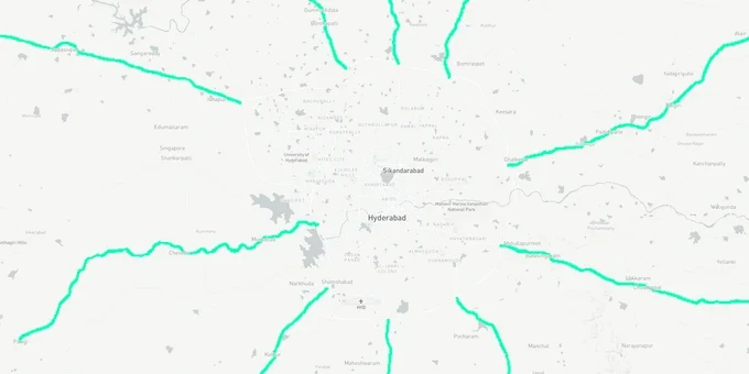
Hyderabad Highways: ORR, NH-44 and Major Road Corridors
Highways Preview
Try the Hyderabad Highways on the map
Sign in once and explore the layer for a full day.
- No card details needed
- Find nearby verified lands for sale
Overview
Hyderabad major highways land buying decisions hinge on two regulatory systems most brokers will not explain. The 1acre Hyderabad Highways layer maps the city's major road network, including the 162 km Outer Ring Road and national highways NH-44, NH-65, NH-163, and NH-765, which together shape the HMDA Master Plan 2031 growth corridors across 5,965 sq km (Master Plan coverage area; total HMDA jurisdiction is approximately 7,257 sq km, extended further to ~10,472 sq km via G.O. Ms. No. 68 dated March 2025). Buying land near any of these roads without checking the ORR Growth Corridor regulations, the GO 111 bio-conservation zone boundary, and HMDA Master Plan zone classification creates legal exposure that no sale deed can fix after the fact. This page covers both risks and the corridors that are genuinely investable.
NH-44 Medchal and Kompally, NH-65 Sadashivpet, NH-163 Ghatkesar: Where Highway Proximity Adds Verifiable Value
Hyderabad major highways land buying generates genuine returns in three directional corridors, each driven by a specific highway and employment anchor. The key distinction between investable and speculative plots is whether the land sits outside the GO 111 boundary and carries HMDA or DTCP layout approval.
North Hyderabad along NH-44 (the Nagpur-Bengaluru national highway) is the most established highway corridor for plot investment. Medchal, Kompally, and Dundigal benefit from proximity to the ORR Exit 9 interchange, the NH-44 national highway, and a concentration of pharmaceutical manufacturing, logistics, and industrial estates. Land in this belt is outside GO 111, within HMDA jurisdiction, and connected to the ORR without entering the ORR Growth Corridor right-of-way. The RRR northern corridor, which links Sangareddy to Choutuppal via Toopran and Gajwel, has NH-44 as a key intersection point; land acquisition for the northern corridor was 94% complete by 2025 with construction underway.
West along NH-65 (the Vijayawada highway, also called Pune-Machilipatnam highway), Sadashivpet near Patancheru ORR Exit 3 sits in an industrial cluster that includes Aurobindo Pharma, MRF, Pepsi, and the National Investment and Manufacturing Zone (NIMZ). This corridor is also outside GO 111 and benefits from dual highway access via NH-65 and the ORR.
East along NH-163 (the Warangal highway), Ghatkesar carries the IT Investment Region (ITIR) designation and has direct ORR and metro extension connectivity, making it the primary east Hyderabad plot investment corridor.
The table below maps four highway corridors and their current investment profile.
Highway Corridor
Key Localities
Primary Employment Driver
GO 111 Status
HMDA / DTCP Approval Available
NH-44 North (Nagpur direction)
Medchal, Kompally, Dundigal
Pharma, industrial, logistics
Outside GO 111
HMDA approved layouts confirmed
NH-65 West (Vijayawada direction via Sadashivpet)
Sadashivpet, Patancheru
National Investment and Manufacturing Zone (NIMZ), Aurobindo Pharma, MRF
Outside GO 111
DTCP approved layouts available
NH-163 East (Warangal highway)
Ghatkesar, Bhongir
Information Technology Investment Region (ITIR), IT corridor, RRR northern node
Outside GO 111
HMDA approved layouts confirmed
NH-765 South (Srisailam highway)
Shadnagar, Kandukur, Kothur
Future City, Pharma City, RRR south
Outside GO 111; check RRR acquisition zone
DTCP and HMDA layouts available
Land values in the Adibatla, Mucherla, and Maheshwaram belt (served by the ORR and NH-765 connection) ranged from ₹15,000 to ₹40,000 per square yard in 2025. Infrastructure projects such as the RRR and ORR have historically driven price movement in peri-urban zones; verify current rates via registered sale deed comparables before transacting. But that appreciation applies to land outside acquisition zones and with valid layout approval; land inside the 100 m RRR right-of-way is subject to compulsory acquisition at approximately ₹25 lakh per acre regardless of market rate.
Was this layer helpful?
Anything wrong, outdated, or missing we want to hear it.
For Land Owners & Agents
Looking to sell your land in Telangana?
I want to sell my land in Telangana
10:32
Plz share your Land's location - We will list it on 1acre map, for Free.
10:32

For Land Buyers
Browse all verified lands & plots in Telangana
Every listing goes through our Preliminary Verification Process.
More Layers in Telangana
See all 22 layers
FCDA Masterplan — Bharat Future City Zone, Hyderabad
View FCDA Bharat Future City zone as a live map overlay — check future city development zones for free on 1acre.in. FCDA...

Hyderabad HMDA Masterplan: Zone Check and Land Use Guide
View Hyderabad Masterplan as a live map overlay – check any plot's land use zone for free on 1acre.in. Hyderabad masterp...
Warangal Masterplan: WUDA Zone Check and Land Use Guide
View Warangal Masterplan as a live map overlay – check any plot's land use zone for free on 1acre.in. Warangal KUDA mast...
More Layers in Telangana
FCDA Masterplan — Bharat Future City Zone, Hyderabad
View FCDA Bharat Future City zone as a live map overlay — check future city development zones for free on 1acre.in. FCDA...
Hyderabad HMDA Masterplan: Zone Check and Land Use Guide
View Hyderabad Masterplan as a live map overlay – check any plot's land use zone for free on 1acre.in. Hyderabad masterp...
Warangal Masterplan: WUDA Zone Check and Land Use Guide
View Warangal Masterplan as a live map overlay – check any plot's land use zone for free on 1acre.in. Warangal KUDA mast...