Hyderabad Metro Lines: Route Map and Corridor Impact
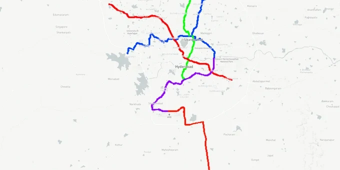
Metro Lines Preview
Try the Hyderabad Metro Lines on the map
Sign in once and explore the layer for a full day.
- No card details needed
- Find nearby verified lands for sale
Overview
Hyderabad metro land buying decisions hinge on one hard fact: the 67 km Phase 1 network (Red, Green, Blue lines, 57 stations) is fully operational, and the state government cleared a 76.4 km Phase 2A expansion across five corridors in November 2024 at an estimated cost of ₹24,269 crore. Properties within 1 km of existing metro stations trade at a 20–30% premium over comparable land further out. This page covers the fraud risks specific to metro-corridor land in Hyderabad, the micro-markets where that premium is real, and how to use the 1acre map layer to verify it before visiting a single plot.
Verification Checklist for Plots Near Hyderabad Metro Corridors
Four documents block almost every Hyderabad metro-corridor land fraud. Three are universal HMDA checks; the fourth is metro-specific. Each check takes minutes online, and the table notes the stations where the relevant risk has been documented in court records or registrar circulars (April 2026 currency).
Check
Where to Verify
Stations Where Issues Documented
What Fraud / Block Looks Like
LP number (HMDA layout approval)
dpms.hmda.gov.in (DPMS portal)
Across all corridors
Fake or mismatched LP number; year invalid; layout outside HMDA limits (DTCP applies)
Section 22-A status
registration.telangana.gov.in / Bhu Bharati
Nagole, LB Nagar, Uppal (court-stay entries on record)
Land blocked for registration; advance pocketed before registration stage reveals the block
Pattadhar passbook
Bhu Bharati (Dharani portal)
Shamshabad, Budwel (Apr 2025 HC-directed SIT case on 180 acres of erstwhile HUDA land)
Survey number / owner mismatch; assigned land mis-sold as freehold
HMRL alignment + setback
hmrl.co.in + 1acre Premium Metro Lines overlay
Phase 2A corridors (Raidurg–Shamshabad, MGBS–Falaknuma Old City)
Plot inside acquisition footprint or restricted setback; sold without disclosing alignment hold
Use the 1acre Premium Hyderabad Metro Lines overlay to check whether your survey number sits within an operational station catchment, a Phase 2A acquisition footprint, or a 22-A prohibited entry — one map view, before any site visit.
Miyapur, Gachibowli, Uppal: Where Metro Proximity Actually Converts to Price
Three distinct tiers have emerged in Hyderabad metro land buying across the existing network. Understanding the difference prevents overpaying on speculation or underpaying on a genuine growth corridor.
The first tier covers stations with proven IT cluster adjacency: Gachibowli, Madhapur, and HITEC City (Blue Line). Gachibowli recorded 78% price appreciation between 2021 and 2024; HITEC City recorded 62% over the same period. These are not prospective gains, they are done deals. Entry prices for plots here now range from ₹25,000–₹1,00,000 per square yard depending on zone, making them capital-preservation plays, not multibagger land bets.
The second tier covers terminal stations with documented Phase 2 extension proposals: Miyapur (Red Line terminus, proposed 14 km extension to Patancheru), LB Nagar (Red Line terminus, 5 km Nagole extension proposed), and Uppal (Blue Line corridor). These localities range from ₹50,000–₹90,000 per square yard in most sub-pockets. Phase 2A was cleared by the state in November 2024 and forwarded for central government approval; construction timelines have been set at four years from sanction.
The third tier is speculative: land near proposed Phase 2 airport corridors (Shamshabad, Budwel, Rajendranagar) where projections of 20–30% appreciation exist, but only if infrastructure timelines hold. The Shamshabad corridor is the same geography where the 2025 HMDA land fraud SIT case arose.
Corridor / Locality
Metro Line
Current Range (₹/sq yd)
Phase 2 Trigger
Risk Level
Gachibowli / HITEC City
Blue Line
₹50,000–₹1,00,000
None (established)
Low (pricing risk)
Miyapur / Bachupally
Red Line (terminal)
₹50,000–₹90,000
Patancheru extension
Medium
Uppal / LB Nagar
Red + Blue (terminals)
₹50,000–₹90,000
LB Nagar–Nagole extension
Medium
Shamshabad / Budwel
Phase 2 airport corridor
₹30,000–₹70,000
Airport Metro (DPR stage)
High (fraud + delay risk)
Kompally / Suchitra
Phase 2 (Phase 2B JBS–Medchal)
₹6,000–₹12,000
JBS–Medchal corridor
High (early stage)
The most misread corridor is Kompally. The north Hyderabad land market is genuinely more affordable, but Phase 2B (which covers the JBS–Medchal–Shamirpet routes) only received administrative sanction in June 2025 and the DPR was submitted to the Centre the same month. Construction has not started. Buying here on metro proximity is buying on a timeline that could shift.
Was this layer helpful?
Anything wrong, outdated, or missing we want to hear it.
For Land Owners & Agents
Looking to sell your land in Telangana?
I want to sell my land in Telangana
10:32
Plz share your Land's location - We will list it on 1acre map, for Free.
10:32

For Land Buyers
Browse all verified lands & plots in Telangana
Every listing goes through our Preliminary Verification Process.
More Layers in Telangana
See all 22 layers
Hyderabad HMDA Masterplan: Zone Check and Land Use Guide
View Hyderabad Masterplan as a live map overlay – check any plot's land use zone for free on 1acre.in. Hyderabad masterp...
Hyderabad Outer Ring Road (ORR)
View the Hyderabad ORR Growth Corridor on a live map overlay - check HMDA layout approval, zone status and acquisition r...
Hyderabad Regional Ring Road (RRR): Route Map and Land Impact
View RRR alignment as a live map overlay – check land acquisition risk and plot proximity free on 1acre.in. Hyderabad Re...
More Layers in Telangana
Hyderabad HMDA Masterplan: Zone Check and Land Use Guide
View Hyderabad Masterplan as a live map overlay – check any plot's land use zone for free on 1acre.in. Hyderabad masterp...
Hyderabad Outer Ring Road (ORR)
View the Hyderabad ORR Growth Corridor on a live map overlay - check HMDA layout approval, zone status and acquisition r...
Hyderabad Regional Ring Road (RRR): Route Map and Land Impact
View RRR alignment as a live map overlay – check land acquisition risk and plot proximity free on 1acre.in. Hyderabad Re...