Warangal Masterplan: WUDA Zone Check and Land Use Guide
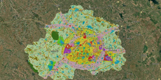
Warangal Masterplan Preview
Try the Warangal Masterplan on the map
Sign in once and explore the layer for a full day.
- No card details needed
- Find nearby verified lands for sale
Overview
The Warangal KUDA masterplan zone is the primary land-use classification governing all property transactions in the Kakatiya (Warangal) Development Area. The Kakatiya Urban Development Authority (KUDA), constituted under G.O. Ms. No. 1177 M.A. dated 6 November 1981, finalised the KUDA Master Plan 2041 covering 1,805 sq km across 181 revenue villages in three districts: Warangal Rural, Warangal Urban, and Jangaon, spanning 19 mandals. The Government of Telangana's MA&UD Department formally approved the plan in November 2024. This page covers the zone classifications, the illegal layout problem that has put over 200 unapproved layouts in KUDA jurisdiction, which corridors the plan actively supports, and how to use the 1acre Warangal Masterplan layer before committing to any purchase.
The Zone Classification Trap: Why Illegal Layouts and Commercial Zoning in KUDA Jurisdiction Have Burned Buyers
Warangal has a documented illegal layout problem that directly intersects with the newly approved master plan. The Telangana government's Registration and Stamps Commissioner issued an order blocking registration of any plot or sub-division within KUDA limits unless it carries a valid layout approval from the competent authority. The KUDA Planning Officer confirmed that over 70 unapproved layouts had been identified and issued notices; the actual count of illegal layouts across the full 1,805 sq km KUDA jurisdiction exceeds 200, concentrated primarily in Fort Warangal, Kazipet, Hanamkonda, Inavole, Sangem, Hasanparthy, and Dharmasagar mandals. Most are small layouts of one to three acres, priced cheaply to attract buyers who assume a future Layout Regularisation Scheme will bail them out.
The KUDA Master Plan 2041 adds a second layer of risk: zone reclassification. About 3,000 objections were submitted against the draft plan, with farmers from Somidi, Madikonda, and Mamnoor opposing the classification of their agricultural lands into the commercial zone. The plan was approved despite those objections. Buyers who purchased agricultural-use land in those villages on the assumption that commercial zoning would increase their development rights now face the reality that commercial zoning also attracts higher development charges, infrastructure contributions, and regulatory compliance requirements under the Telangana Urban Areas (Development) Act 1975.
The KUDA Master Plan 2041 includes the following principal land-use zones across the development area.
Zone
Permitted Principal Use
KUDA Layout Approval Required?
Key Risk for Buyers
Residential
Housing, ancillary shops
Yes
Over 200 illegal layouts operating without approval
Commercial
Shops, offices, commercial complexes
Yes
Agricultural land in Somidi, Mamnoor reclassified; buyer opposition documented
Mixed Use
Residential + commercial combination
Yes
Unapproved mixed ventures marketed as KUDA-approved
Industrial
Manufacturing, warehouses
Yes, plus TGIIC/KUDA
Dharmasagar area; verify zone before buying
Growth Corridors
High-intensity development along key roads
Yes; specific corridor norms
NH-163 frontage plots often sold without plan sanction
Public and Semi-Public
Civic, institutional uses
Authority-specific
Cannot be converted for private residential use
Agricultural
Farming; no residential construction permitted
CLU required for any other use
Majority of KUDA periphery; most misrepresented zone
Recreational
Parks, open space
No construction
Lake and tank buffer zones fall here
If a seller cannot produce a KUDA layout approval number, a valid sale deed dated on or before August 26, 2020 for any LRS-eligible plot, and a zone confirmation matching the current Master Plan 2041, the transaction carries significant legal and registration risk.
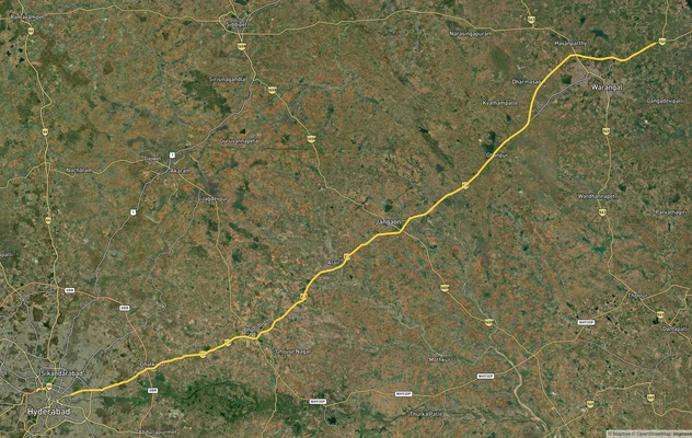
Corridors Where the KUDA Masterplan Zone Drives Land Value in Warangal
Two distinct growth stories are playing out inside the KUDA development area, and the master plan zone is the key to reading which is which. The NH-163 Hyderabad-Warangal corridor and the Madikonda IT belt are zoned for growth and carry active infrastructure investment; the agricultural fringe on routes to Khammam, Karimnagar, and Narsampet carries speculative pricing without corresponding zone confirmation.
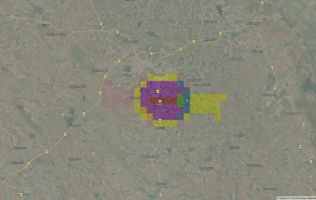
Madikonda is the strongest single node in the KUDA growth story. The IT SEZ at Madikonda already hosts Tech Mahindra and Cyient, and the master plan designates it as an IT-industrial growth zone. Residential plot prices in Madikonda ranged from approximately ₹12,000 to ₹22,000 per square yard in early 2025, with the average sale around ₹72 lakh. The Kakatiya Mega Textile Park, covering 1,350 acres on Warangal's outskirts, is projected to create 40,000 jobs; land near that park's perimeter is zoned industrial and commercial under the master plan. The Kazipet Railway Wagon Manufacturing Unit, being built at ₹521 crore, is expected to be operational by 2025 and reinforces the industrial zone classification around Kazipet. The Warangal Outer Ring Road is operational as a bypass around the core city, and the proposed Regional Ring Road is under planning, with land near key interchange points already attracting speculative interest.
The table below maps the active growth corridors to their dominant KUDA 2041 zone and known buyer risk.
Corridor / Locality
Dominant KUDA 2041 Zone
Growth Driver
Key Risk
Madikonda
IT Industrial + Residential
IT SEZ, Tech Mahindra, Cyient, Textile Park
Agricultural pockets around the SEZ sold as residential
Hanamkonda
Residential + Commercial
NIT Warangal, Kakatiya University, city centre
Fort Warangal, Hanamkonda among highest illegal layout concentrations
NH-163 / Hyderabad highway frontage
Growth Corridor
Hyderabad-Warangal Economic Corridor, 4-lane NH-163
Frontage plots sold without layout sanction; high unapproved layout density
Kazipet
Industrial + Residential
Railway Wagon Unit, Kazipet Junction
Industrial zone misrepresented as residential in adjacent plots
Mamnoor
Mixed / Commercial (post-reclassification)
Mamnoor Airport revival (approved by central government)
Farmers opposed commercial reclassification; disputes ongoing
Somidi
Commercial (reclassified)
Commercial zone in Master Plan 2041
Farmers submitted objections; zone confirmed in approved plan
The most misread opportunity in Warangal is the Mamnoor airport belt. The central government has approved the revival of the Mamnoor Airport, and land prices around it are rising in anticipation. But the airport is approximately 15 km from Madikonda and sits on land whose commercial reclassification under the master plan was contested. Before purchasing near Mamnoor, confirm both the current zone designation in the approved KUDA Master Plan 2041 and the airport's actual operational timeline.
Was this layer helpful?
Anything wrong, outdated, or missing we want to hear it.
For Land Owners & Agents
Looking to sell your land in Telangana?
I want to sell my land in Telangana
10:32
Plz share your Land's location - We will list it on 1acre map, for Free.
10:32

For Land Buyers
Browse all verified lands & plots in Telangana
Every listing goes through our Preliminary Verification Process.
More Layers in Telangana
See all 22 layers
Warangal - Khammam Expressway
View Warangal - Khammam Expressway alignment as a live map overlay – check land acquisition risk and plot proximity free...
Warangal Highway - NH-163
View the Warangal Highway - NH-163 corridor on a live map overlay – check zoning, approvals and acquisition risk free on...
Warangal Air Funnel Zones: Building Height Restrictions
View Warangal Air Funnel Zones on a live map – check height clearance restrictions on any plot for free on 1acre.in. War...
More Layers in Telangana
Warangal - Khammam Expressway
View Warangal - Khammam Expressway alignment as a live map overlay – check land acquisition risk and plot proximity free...
Warangal Highway - NH-163
View the Warangal Highway - NH-163 corridor on a live map overlay – check zoning, approvals and acquisition risk free on...
Warangal Air Funnel Zones: Building Height Restrictions
View Warangal Air Funnel Zones on a live map – check height clearance restrictions on any plot for free on 1acre.in. War...