Ratan Tata Road: Raviryal-Amangal Greenfield Radial Road
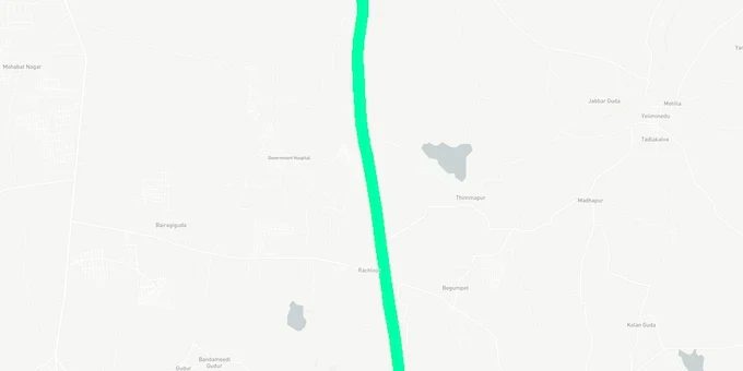
Ratan Tata Road Preview
Try the Ratan Tata Road on the map
Sign in once and explore the layer for a full day.
- No card details needed
- Find nearby verified lands for sale
Overview
The Ratan Tata Road Hyderabad layer on 1acre maps the alignment of a 41.5 km greenfield radial expressway connecting the Outer Ring Road at Raviryal (Tata Interchange) to the Regional Ring Road at Amangal, based on land acquisition notices issued by the Government of Telangana. Executed by HMDA and Hyderabad Growth Corridor Limited (HGCL), the project costs ₹4,030 crore across two phases (Phase 1: ₹1,665 crore; Phase 2: ₹2,365 crore) and passes through 14 villages in Rangareddy district. This page explains who is at acquisition risk, which corridors sit outside the right-of-way but gain from the road, and what every buyer near the alignment must verify first.
Which Plots Are Inside the 100-Metre Right-of-Way and at Acquisition Risk
The Ratan Tata Road is being built with a 100-metre right-of-way, wider than the existing Outer Ring Road. That width matters to every landowner and buyer in the 14 villages the road crosses. Land within the notified corridor is subject to acquisition under the Right to Fair Compensation and Transparency in Land Acquisition, Rehabilitation and Resettlement (Telangana Amendment) Act, 2013.
The Rangareddy District Government has published gazette notifications for specific survey numbers in villages including Kongarakhurd and Kongarakalan in Maheshwaram mandal, Ferozguda in Ibrahimpatnam mandal, and Gummadavelly, Lemoor, Meerkhanpet, Panjaguda, Rachulur, and Thimmapur in Kandukur mandal. As of early 2026, land acquisition for approximately 1,003 acres across the alignment is ongoing; construction has begun on government-held land to avoid delays while private land acquisition continues.
The table below maps the mandals the road passes through, their gazette status, and the primary risk for landowners and buyers in each.
Mandal
Phase
Gazette Villages Published
Risk for Private Plots
Maheshwaram
Phase 1 (19.2 km)
Kongarakhurd, Kongarakalan
Acquisition proceedings active
Ibrahimpatnam
Phase 1 (19.2 km)
Ferozguda
Acquisition proceedings active
Kandukur
Phase 1 and 2
Gummadavelly, Lemoor, Meerkhanpet, Panjaguda, Rachulur, Thimmapur
Acquisition proceedings active; Meerkhanpet is midpoint interchange
Yacharam
Phase 2 (22.3 km)
Not yet published at source date
Alignment confirmed, formal notice expected
Kadthal
Phase 2 (22.3 km)
Not yet published at source date
Alignment confirmed, formal notice expected
Amangal
Phase 2 (22.3 km)
Not yet published at source date
Alignment terminates at RRR junction
Buying any plot in these 14 villages without first checking the survey number against the official gazette notification is a mistake with no clean exit. Compensation for acquired land is estimated at approximately ₹25 lakh per acre; if a buyer paid market rates expecting development rights, that gap is unrecoverable.
Maheshwaram, Ibrahimpatnam, Kandukur and Kadthal: Where the Road Drives Value Outside the Acquisition Zone
Land sitting beside, not under, a 100-metre expressway has a different investment profile entirely. The Ratan Tata Road is the primary access spine for Bharat Future City, a 30,000-acre project in Kandukur, Yacharam, and Kadthal mandals that the Telangana Cabinet formally approved in 2025, replacing the earlier Hyderabad Pharma City mandate. Future City is planned as India's first net-zero greenfield smart city with focus sectors including pharmaceuticals, artificial intelligence, medical tourism, and advanced manufacturing. In Meerkhanpet village of Kandukur mandal alone, a 620-acre layout has been developed to compensate 11,500 farmers affected by land acquisition, with TGIIC overseeing plot allotment.
The road also connects to Pharma City, situated in Kandukur, Kadthal, and Yacharam mandals, which has attracted 350 companies including Dr Reddy's Laboratories, Biocon, and Novartis. The employment projection for the broader Future City zone is 560,000 people, supported by USD 9.7 billion in targeted investment. Land values in the Adibatla, Mucherla, and Maheshwaram belt ranged from ₹15,000 to ₹40,000 per square yard in 2025, with the Ratan Tata Expressway and Regional Ring Road cited as driving 15% to 50% appreciation in emerging zones.
The table below maps the four main investment corridors near the Ratan Tata Road alignment and their current risk-return profile.
Corridor
Distance from Road
Primary Driver
Investment Profile
Key Risk
Maheshwaram
Adjacent (Phase 1)
Proximity to ORR exit + Future City
Residential and industrial township demand
Check survey numbers against gazette; some plots in acquisition zone
Ibrahimpatnam
Adjacent (Phase 1)
Adibatla IT SEZ, TATA Aerospace, TCS Adibatla nearby
Mixed residential and industrial
Confirm plots are outside 100-metre ROW
Kandukur / Meerkhanpet
Midpoint interchange (Phase 2)
Future City anchor zone; TGIIC farmer plot layout
Industrial, logistics, workforce housing
Active land acquisition in Meerkhanpet village itself
Kadthal / Yacharam
Phase 2 terminus area
Pharma City; Future City southern zone
Long-hold industrial and commercial
Gazette for Phase 2 villages not yet published; confirm alignment
Kadthal and Yacharam attract the highest speculative interest because Pharma City sits directly in these mandals and the road terminus provides direct ORR-to-RRR connectivity. That upside is real. The risk is that Phase 2 gazette notifications for these mandals had not been published at the time of writing; buyers need to track the HMDA and Rangareddy District websites for any new survey number notifications before transacting.
Was this layer helpful?
Anything wrong, outdated, or missing we want to hear it.
For Land Owners & Agents
Looking to sell your land in Telangana?
I want to sell my land in Telangana
10:32
Plz share your Land's location - We will list it on 1acre map, for Free.
10:32

For Land Buyers
Browse all verified lands & plots in Telangana
Every listing goes through our Preliminary Verification Process.
More Layers in Telangana
See all 22 layers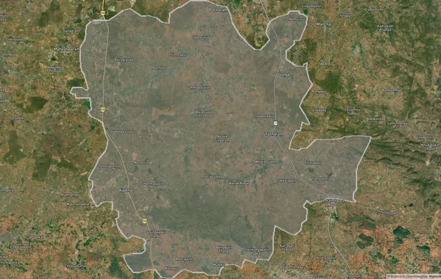
FCDA Masterplan — Bharat Future City Zone, Hyderabad
View FCDA Bharat Future City zone as a live map overlay — check future city development zones for free on 1acre.in. FCDA...

Hyderabad HMDA Masterplan: Zone Check and Land Use Guide
View Hyderabad Masterplan as a live map overlay – check any plot's land use zone for free on 1acre.in. Hyderabad masterp...
Warangal Masterplan: WUDA Zone Check and Land Use Guide
View Warangal Masterplan as a live map overlay – check any plot's land use zone for free on 1acre.in. Warangal KUDA mast...
More Layers in Telangana
FCDA Masterplan — Bharat Future City Zone, Hyderabad
View FCDA Bharat Future City zone as a live map overlay — check future city development zones for free on 1acre.in. FCDA...
Hyderabad HMDA Masterplan: Zone Check and Land Use Guide
View Hyderabad Masterplan as a live map overlay – check any plot's land use zone for free on 1acre.in. Hyderabad masterp...
Warangal Masterplan: WUDA Zone Check and Land Use Guide
View Warangal Masterplan as a live map overlay – check any plot's land use zone for free on 1acre.in. Warangal KUDA mast...