Andhra Pradesh CRZ
Andhra Pradesh Coastal Zone Management Authority

Overview
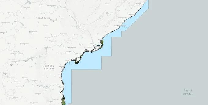
The Andhra Pradesh CRZ layer plots the Coastal Regulation Zone footprint along the state's 974 km coastline, the third longest in India after Gujarat and Tamil Nadu. It mirrors the Coastal Zone Management Plan prepared by NCSCM under CRZ Notification 2019 (G.S.R. 37(E)) for nine coastal districts: Srikakulam, Vizianagaram, Visakhapatnam, East Godavari, West Godavari, Krishna, Guntur, Prakasam, and Nellore. The Andhra Pradesh Coastal Zone Management Authority (APCZMA) is the regulatory body. APCZMA reported 53 violation cases over the past decade. This page shows what falls inside CRZ-I, II, III A, III B, and IV across the entire AP coast.
Regulatory Red Flags Around Coringa, Krishna and the Aquaculture Belt
Andhra Pradesh has two of India's listed Critical Vulnerable Coastal Areas: Coringa and Krishna CVCA, both named explicitly in CRZ Notification 2019. These mangrove stretches in East Godavari and Krishna districts are CRZ-I A by default, with no private construction permitted. The state also has 18,552 sq km of coastal wetlands, the largest such footprint of any Indian state.
The fact-pack on what each zone permits in Andhra Pradesh, drawn from CRZ Notification 2019 and the AP CZMP report.
CRZ-I A
Permitted Use
Coringa CVCA, Krishna CVCA, mangroves, sand dunes, turtle nesting
Requires CRZ Clearance?
No new construction; only utility
Prohibited Without?
Any building
Commonly Misrepresented?
Sold as "beach plots"
CRZ-I B
Permitted Use
Inter-tidal between LTL and High Tide Line
Requires CRZ Clearance?
Salt works, pipelines only
Prohibited Without?
Houses, resorts
Commonly Misrepresented?
Marketed as "beachfront villas"
CRZ-II
Permitted Use
Built-up urban municipal areas (Visakhapatnam, Kakinada, Vijayawada)
Requires CRZ Clearance?
Yes, on landward side of existing road
Prohibited Without?
Construction on seaward side
Commonly Misrepresented?
Confused with CRZ-III rural
CRZ-III A
Permitted Use
Densely populated rural; NDZ 50 m from HTL
Requires CRZ Clearance?
Beyond NDZ only
Prohibited Without?
Construction inside 50 m
Commonly Misrepresented?
Quoted as "DTCP approved"
CRZ-III B
Permitted Use
Sparse rural; NDZ 200 m from HTL
Requires CRZ Clearance?
Beyond NDZ only
Prohibited Without?
Anything inside 200 m
Commonly Misrepresented?
Sold without 2011 census check
CRZ-IV A/B
Permitted Use
Sea up to 12 nautical miles + tidal water bodies
Requires CRZ Clearance?
Fishing only
Prohibited Without?
Reclamation, dwellings
Commonly Misrepresented?
Sold as "river-facing"
Zone Code
Permitted Use
Requires CRZ Clearance?
Prohibited Without?
Commonly Misrepresented?
CRZ-I A
Coringa CVCA, Krishna CVCA, mangroves, sand dunes, turtle nesting
No new construction; only utility
Any building
Sold as "beach plots"
CRZ-I B
Inter-tidal between LTL and High Tide Line
Salt works, pipelines only
Houses, resorts
Marketed as "beachfront villas"
CRZ-II
Built-up urban municipal areas (Visakhapatnam, Kakinada, Vijayawada)
Yes, on landward side of existing road
Construction on seaward side
Confused with CRZ-III rural
CRZ-III A
Densely populated rural; NDZ 50 m from HTL
Beyond NDZ only
Construction inside 50 m
Quoted as "DTCP approved"
CRZ-III B
Sparse rural; NDZ 200 m from HTL
Beyond NDZ only
Anything inside 200 m
Sold without 2011 census check
CRZ-IV A/B
Sea up to 12 nautical miles + tidal water bodies
Fishing only
Reclamation, dwellings
Sold as "river-facing"
The AP-specific trap is the assigned land plus aquaculture pond combination. Large stretches in Krishna and East Godavari districts are dotted with aquaculture ponds APZ assigned land, where assigned parcels intermixed with private survey numbers get sold as "future urban" land. Many of these sit inside CRZ-III B or CRZ-I A buffers, and APCZMA enforcement has flagged 53 violations over the last decade. If a parcel near Kakinada or Machilipatnam shows aquaculture history without CRZ classification on the patta, treat the deal as untested.
Growth Corridors From Visakhapatnam to Krishnapatnam
Andhra Pradesh's coast splits into three personalities. The Uttarandhra belt (Srikakulam to Visakhapatnam) carries CRZ-II urban around Vizag city plus CRZ-III B beyond. The Krishna-Godavari twin delta is mostly CRZ-I A and CRZ-IV B, dominated by mangroves and aquaculture. The southern Prakasam-Nellore stretch is CRZ-III B with major port-driven exemptions where notified port limits override NDZ. The Visakhapatnam Kakinada Krishnapatnam ports anchor the highest-value coastal property pockets.
The corridors most asked about, mapped against CRZ classification.
Visakhapatnam city, RK Beach to Yarada
Zone (AP CZMP)
CRZ-II + CRZ-I (Yarada cliffs)
Growth Driver
Premium urban, port, IT
Known Risk
Construction only landward of existing roads
Bheemili to Bhogapuram
Zone (AP CZMP)
CRZ-III A and III B
Growth Driver
Bhogapuram airport, NRI demand
Known Risk
NDZ enforced; airport-corridor parcels mixed
Kakinada deepwater + spit
Zone (AP CZMP)
CRZ-II + CRZ-I A (mangrove buffer)
Growth Driver
Major port, oil refining
Known Risk
Coringa CVCA buffer extends here
Coringa belt (East Godavari)
Zone (AP CZMP)
CRZ-I A (CVCA)
Growth Driver
Tourism, aquaculture
Known Risk
Blanket restriction; private builds blocked
Machilipatnam, Nizampatnam
Zone (AP CZMP)
CRZ-II + CRZ-III mix
Growth Driver
Greenfield port construction
Known Risk
Notified port limits exempt NDZ; verify boundary
Nellore-Krishnapatnam belt
Zone (AP CZMP)
CRZ-III B + port limits
Growth Driver
Adani-owned Krishnapatnam port
Known Risk
Port exemption applies inside notified limits only
Pulicat Lake fringe
Zone (AP CZMP)
CRZ-I A + CRZ-IV B
Growth Driver
Bird sanctuary, lagoon
Known Risk
Wetland buffer; AP-TN boundary parcels disputed
Corridor / Locality
Zone (AP CZMP)
Growth Driver
Known Risk
Visakhapatnam city, RK Beach to Yarada
CRZ-II + CRZ-I (Yarada cliffs)
Premium urban, port, IT
Construction only landward of existing roads
Bheemili to Bhogapuram
CRZ-III A and III B
Bhogapuram airport, NRI demand
NDZ enforced; airport-corridor parcels mixed
Kakinada deepwater + spit
CRZ-II + CRZ-I A (mangrove buffer)
Major port, oil refining
Coringa CVCA buffer extends here
Coringa belt (East Godavari)
CRZ-I A (CVCA)
Tourism, aquaculture
Blanket restriction; private builds blocked
Machilipatnam, Nizampatnam
CRZ-II + CRZ-III mix
Greenfield port construction
Notified port limits exempt NDZ; verify boundary
Nellore-Krishnapatnam belt
CRZ-III B + port limits
Adani-owned Krishnapatnam port
Port exemption applies inside notified limits only
Pulicat Lake fringe
CRZ-I A + CRZ-IV B
Bird sanctuary, lagoon
Wetland buffer; AP-TN boundary parcels disputed
The most misunderstood corridor is the Bhogapuram airport ribbon. Buyers see the under-construction airport and assume coastal parcels are unlocked. Most parcels north of Bheemili sit in CRZ-III A or III B, with CRZ-III A and CRZ-III B classification depending on village-level Census 2011 density. APCZMA clearance is mandatory regardless of DTCP approval, and the airport-corridor brochures rarely show the NDZ overlay against survey numbers.
Frequently Asked Questions
What is Andhra Pradesh CRZ and how does it apply to my plot?
Andhra Pradesh CRZ** covers the entire 974 km coastline within 500 metres of HTL, plus 50 metres along tidal creeks and water bodies. It is governed by CRZ Notification 2019 and the AP CZMP under APCZMA, applicable to all nine coastal districts.
How do I check if my plot in AP falls under CRZ?
Match your survey number against the approved AP CZMP map prepared by NCSCM. The classification will read CRZ-I, II, III A, III B, or IV. The CZMP map is published district-wise and indexed by OSM sheet numbers covering the full coast.
Can I build a house near Visakhapatnam beach?
Yes, but only beyond the NDZ in CRZ-III, on the landward side of existing roads in CRZ-II. APCZMA clearance is mandatory through the Parivesh portal regardless of GVMC, VMRDA, or DTCP approvals. CRZ-I parcels (cliffs, dunes) cannot be built on.
What is the No Development Zone for AP CRZ-III?
NDZ in CRZ-III A and CRZ-III B depends on Census 2011 density. CRZ-III A villages (above 2,161 per sq km) get 50 m. CRZ-III B villages get 200 m. Along tidal water bodies, NDZ is 50 m or creek width, whichever is less.
Who gives CRZ clearance in Andhra Pradesh?
APCZMA recommends clearance for CRZ-II and CRZ-III projects through the Parivesh portal. CRZ-I and CRZ-IV proposals require MoEFCC clearance at the Centre. APCZMA has reported 53 violation cases over ten years, indicating active enforcement.
Are Coringa and Krishna mangroves under CVCA?
Yes. CRZ Notification 2019 lists Coringa (East Godavari) and Krishna (Krishna district) as Critical Vulnerable Coastal Areas. Both are managed with fisher community involvement, classified as CRZ-I A, and no private construction is permitted within the notified mangrove and buffer zones.
Can NRIs buy plots in Andhra Pradesh CRZ areas?
Yes for non-agricultural land, subject to FEMA rules and APCZMA clearance for any construction. Agricultural land purchase by NRIs faces standard RBI restrictions. CRZ classification does not bar ownership but freezes development rights inside NDZ.
How is the AP coastline classified under CRZ 2019?
The 974 km coast is divided across nine coastal districts into CRZ-I A (Coringa, Krishna CVCA, dunes), CRZ-I B (intertidal), CRZ-II (Visakhapatnam, Kakinada urban), CRZ-III A and III B (rural villages by density), and CRZ-IV A and IV B (sea and tidal water bodies).
Disclaimer
Data Source & Verification
Source
Official Andhra Pradesh Coastal Zone Management Authority documents
Official Website
appcb.ap.gov.in
Coordinate Reference System
EPSG:4326 (WGS 84)
Geometry Type
Polygon / MultiPolygon
Data Format
Vector (GeoJSON) + Raster Tiles
Last Verified
2026
Status
Active