Khammam - Vijayawada Expressway
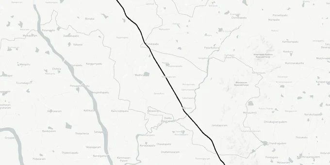
Khammam Vijayawada Expressway Preview
Try the Khammam - Vijayawada Expressway on the map
Sign in once and explore the layer for a full day.
- No card details needed
- Find nearby verified lands for sale
Overview
The Khammam Vijayawada Expressway, designated NH-163G, is an 89.43 km four-lane access-controlled greenfield highway forming the southern segment of the 405 km Nagpur-Vijayawada Economic Corridor under Bharatmala Pariyojana Phase-I. Construction contracts worth Rs. 2,155 crore were awarded to DRA Infra and MEIL in April 2023 across three packages. The corridor passes through both Telangana and Andhra Pradesh, terminating at Jakkampudi on NH-16 near Vijayawada.
The three construction packages are being executed under HAM (Hybrid Annuity Model).
Growth Corridors and Micro-Markets Along the Khammam-Vijayawada Greenfield Alignment
Not every parcel on this corridor is a risk. Land sitting just outside the acquisition band but within 2-5 km of a confirmed interchange has historically performed well once construction enters the physical work stage. The Khammam Vijayawada Expressway creates three distinct micro-market tiers worth tracking.
The first is the Jakkampudi node at the Vijayawada end. Forum discussions and Andhra Pradesh planning documents confirm that Jakkampudi will serve as the point where the new NH-163G connects to NH-16, effectively making it a junction for both the Vijayawada West Bypass and the new Nagpur corridor. Land within 3 km of this node is already attracting early investor attention. The second tier covers the Khammam fringe belt, particularly near V. Venkatayapalem, where Package 1 originates. Agriculture Minister Tummala Nageswara Rao stated in July 2024 that land near Khammam on this alignment is among the costliest affected parcels, which confirms market participants have already priced in part of the upside. The third tier covers mid-corridor villages around the Remidicherla area in Krishna district, where land prices have not yet moved in line with the terminal nodes.
Micro-Market
Tier
Primary Driver
Key Risk
Jakkampudi (Krishna dist.)
High
NH-163G/NH-16 junction + Vijayawada West Bypass
Land already priced; verify survey number not in acquisition
V. Venkatayapalem (Khammam dist.)
Medium
Package 1 origin, regional connectivity
Active land acquisition proceedings underway
Remidicherla belt (Krishna dist.)
Early-stage
Mid-corridor appreciation lag
DPR alignment not fully demarcated on ground
Brahmanapalli (Telangana-AP border)
Speculative
Cross-state corridor node
Delayed construction timeline; land acquisition stalled
The most misunderstood corridor here is the Brahmanapalli belt. Because it sits at the Telangana-Andhra Pradesh state border, it falls under the jurisdiction of two state governments simultaneously. Land acquisition disputes on this stretch contributed to delays flagged in a March 2023 Business Standard report, and physical work had not commenced as of late 2024. Buying here requires clarity on which state's Dharani or registration portal carries the current patta, and whether the survey number sits on the Telangana or the AP side of the boundary.
Was this layer helpful?
Anything wrong, outdated, or missing we want to hear it.
For Land Owners & Agents
Looking to sell your land in Andhra Pradesh?
I want to sell my land in Amaravati
10:32
Plz share your Land's location - We will list it on 1acre map, for Free.
10:32

For Land Buyers
Browse all verified lands & plots in Andhra Pradesh
Every listing goes through our Preliminary Verification Process.
More Layers in Andhra Pradesh
See all 17 layers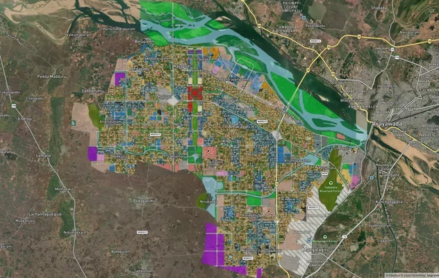
Amaravati APCRDA Masterplan 2050: Zone Check and Land Use Guide
View Amaravati Masterplan as a live map overlay – check any plot's land use zone for free on 1acre.in. APCRDA masterplan...
Kakinada Masterplan: Zone Check and Land Use Guide
View Kakinada Masterplan as a live map overlay – check any plot's land use zone for free on 1acre.in. Kakinada masterpla...
Tirupati TUDA Masterplan: Zone Check and Land Use Guide
View Tirupati Masterplan as a live map overlay – check any plot's land use zone for free on 1acre.in. Tirupati TUDA mast...
More Layers in Andhra Pradesh
Amaravati APCRDA Masterplan 2050: Zone Check and Land Use Guide
View Amaravati Masterplan as a live map overlay – check any plot's land use zone for free on 1acre.in. APCRDA masterplan...
Kakinada Masterplan: Zone Check and Land Use Guide
View Kakinada Masterplan as a live map overlay – check any plot's land use zone for free on 1acre.in. Kakinada masterpla...
Tirupati TUDA Masterplan: Zone Check and Land Use Guide
View Tirupati Masterplan as a live map overlay – check any plot's land use zone for free on 1acre.in. Tirupati TUDA mast...