Amaravati Seed Access Road
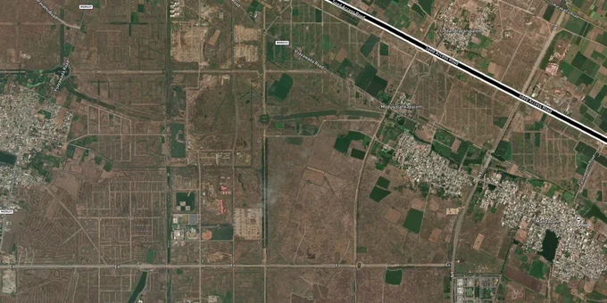
Amaravati Seed Access Road Preview
Try the Amaravati Seed Access Road on the map
Sign in once and explore the layer for a full day.
- No card details needed
- Find nearby verified lands for sale
Overview
The Amaravati Seed Access Road (E3) is a 21-km arterial road built by APCRDA connecting Vijayawada to the Amaravati capital core, running through Undavalli, Penumaka, Venkatapalem, and Dondapadu. Phase 1 (18.3 km to Venkatapalem) is complete. Phase 2 works began September 2025. Phase 3 covers a 3.5-km extension to NH-16 at Kanakadurga Varadhi via a 320-metre cable bridge at Rs 593 crore. This Premium layer on 1acre maps the E3 alignment so buyers can verify plot proximity to the road and check land pooling status before transacting in any of the 29 CRDA villages.
In November 2025, the AP government authorised a second phase of land pooling covering 20,494 acres across seven new villages for major infrastructure including an International Sports City, a greenfield Amaravati airport, a new railway station, and the Inner Ring Road. This significantly expands the investable perimeter beyond the original 29 LPS villages.
Indicative rates as of July 2025 — verify current rates with a registered dealer before any transaction.
Land Pooling Title Risk and the 20-Acre Gap Stalling E3 Phase 2 Near Undavalli and Mandadam
The Amaravati Seed Access Road E3 runs through the Land Pooling Scheme (LPS) area, where 34,389 acres across 29 villages were voluntarily pooled by farmers in exchange for 22 to 30 percent of developed land. That reconstituted land is now being bought and sold actively. The key legal risk is not the E3 road itself but the reconstituted plot status: not all farmer-returned plots have been formally demarcated, and the Andhra Pradesh Capital Region Land Pooling Scheme Rules 2025 (effective July 1, 2025) introduced new formulation and implementation rules that affect resale conditions.
Phase 2 of the E3 road has a specific and documented gap: 70 acres of land were needed between Undavalli and Penumaka, of which 50 acres were cleared and As of January 2026, APCRDA issued a formal land acquisition notification for 12.5758 acres across Undavalli (10.5 acres), Penumaka (0.65 acres), Mandadam (0.7 acres), and Rayapudi (0.72 acres). The negotiation-phase gap is now being resolved through compulsory acquisition.. Farmers from those villages requested alternate plots in Venkatapalem, Mandadam, and Velagapudi; the Chief Minister approved this land allocation, but actual tender issuance and construction on the pending stretch depend on that swap being executed.
The table below shows the E3 corridor's three phases and their current status:
Phase
Stretch
Length
Status
Phase 1
Dondapadu to Venkatapalem
18.3 km (14 km 8-lane completed)
Complete
Phase 2
Venkatapalem to Undavalli
Remaining of 21 km
Works started September 2025; 12.5758 acres under formal acquisition notification (January 2026)
Phase 3
Prakasam Barrage to Manipal Hospital / NH-16
3.5 km + 320m cable bridge
Works started; Rs 593 crore budget
The E3 road was paused under the YSRCP government from 2019 to 2024. That five-year halt is directly relevant to buyers: any plot in an LPS village along the E3 whose development milestones were due between 2019 and 2024 may have delayed returns or incomplete reconstitution. Before purchasing any land pooling plot near Undavalli or Penumaka, verify the reconstituted plot demarcation status directly with APCRDA and confirm whether the survey number has been formally transferred.
Venkatapalem to Dondapadu: Which E3 Corridor Villages Carry Real Investment Value in 2025
Phase 1 of the Amaravati Seed Access Road is operational; that stretch is where investment is grounded today. Venkatapalem is the strongest node: the E3 road, proposed BITS Pilani campus near Venkatapalem — verify current status with APCRDA, TTD infrastructure, and 5-star hotels are all concentrated here. Dondapadu at the far end carries lower prices but thinner near-term demand. Velagapudi, near the Secretariat and High Court zone, commands the highest rates but has the least remaining available stock.
The table below shows key villages along the E3 corridor with July 2025 land rates and the primary signal:
Village
Position on E3
Price Range (July 2025)
Signal
Key Risk
Undavalli
E3 near NH-16 junction
Rs 35,000+/sq.yd
High connectivity; bridge terminus
12.5758-acre formal acquisition (Jan 2026); Phase 2 pending
Penumaka
E3 Phase 2 stretch
Rs 38,000+/sq.yd
Strong demand; capital adjacency
Phase 2 completion uncertain
Venkatapalem
Phase 1 complete
Rs 31,000-55,000/sq.yd
TTD, BITS Pilani, hotels nearby
Wide price band; verify plot zone
Mandadam
E3 adjacent; CRDA core
Rs 40,000-50,000/sq.yd
Capital region core; government institutions
LPS reconstitution status varies
Velagapudi
Secretariat zone
Rs 45,000-60,000/sq.yd
High Court, Secretariat proximity
Limited stock; premium fully priced
Dondapadu
E3 western end
Rs 28,000/sq.yd
Lower entry point; Phase 1 access
Thinner near-term demand driver
Venkatapalem is the most misread market on this corridor. Prices range from Rs 31,000 to Rs 55,000 per sq.yd, a spread too wide to treat as a single market. The lower end reflects agricultural conversion land without confirmed CRDA zoning; the upper end reflects plots with direct E3 road frontage near TTD and BITS Pilani. Confirm the plot category (CRDA reconstituted vs agricultural vs layout) before pricing any Venkatapalem transaction. The World Bank has committed $800 million for Amaravati Phase 1 infrastructure (2025-2029); that funding commitment gives this corridor more institutional backing than at any point in its history, but the 12.5758-acre Phase 2 formal acquisition gap and the documented 2019-2024 project halt remain live risks.
Was this layer helpful?
Anything wrong, outdated, or missing we want to hear it.
For Land Owners & Agents
Looking to sell your land in Andhra Pradesh?
I want to sell my land in Amaravati
10:32
Plz share your Land's location - We will list it on 1acre map, for Free.
10:32

For Land Buyers
Browse all verified lands & plots in Andhra Pradesh
Every listing goes through our Preliminary Verification Process.
More Layers in Andhra Pradesh
See all 17 layers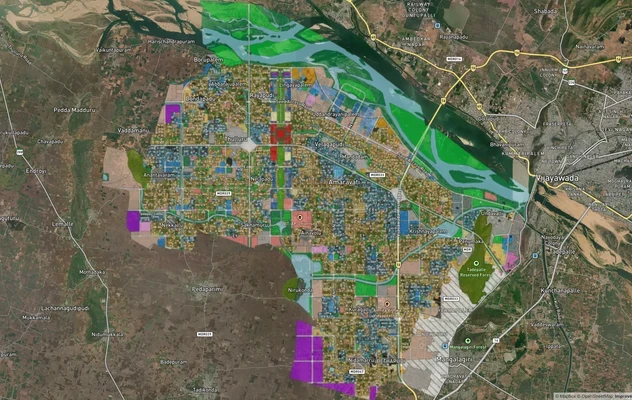
Amaravati APCRDA Masterplan 2050: Zone Check and Land Use Guide
View Amaravati Masterplan as a live map overlay – check any plot's land use zone for free on 1acre.in. APCRDA masterplan...
Amaravati - Anantapur Greenfield Expressway
View Amaravati - Anantapur Greenfield Expressway alignment as a live map overlay – check land acquisition risk and plot ...
Kakinada Masterplan: Zone Check and Land Use Guide
View Kakinada Masterplan as a live map overlay – check any plot's land use zone for free on 1acre.in. Kakinada masterpla...
More Layers in Andhra Pradesh
Amaravati APCRDA Masterplan 2050: Zone Check and Land Use Guide
View Amaravati Masterplan as a live map overlay – check any plot's land use zone for free on 1acre.in. APCRDA masterplan...
Amaravati - Anantapur Greenfield Expressway
View Amaravati - Anantapur Greenfield Expressway alignment as a live map overlay – check land acquisition risk and plot ...
Kakinada Masterplan: Zone Check and Land Use Guide
View Kakinada Masterplan as a live map overlay – check any plot's land use zone for free on 1acre.in. Kakinada masterpla...