Bengaluru - Vijayawada Expressway
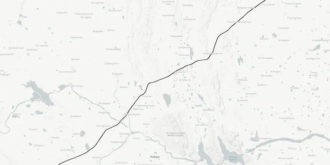
Bengaluru Vijayawada Expressway Preview
Try the Bengaluru - Vijayawada Expressway on the map
Sign in once and explore the layer for a full day.
- No card details needed
- Find nearby verified lands for sale
Overview
The Bengaluru Vijayawada Expressway (NH-544G) spans a total of 624 km, comprising a 343 km greenfield core from Kodikonda to Addanki and approximately 281 km of brownfield upgrades connecting Bengaluru and Vijayawada at either end. It is a 4-6 lane access-controlled greenfield-plus-brownfield highway notified as NH-544G under Bharatmala Pariyojana Phase I. It runs from Kodikonda on NH-44 in Sri Sathya Sai district to Addanki on NH-16 in Bapatla district, with a 343 km greenfield core from Kodikonda to Addanki across Anantapur, YSR Kadapa, SPS Nellore, and Prakasam. NHAI (National Highways Authority of India) awarded all 14 construction packages by February 2023. Prime Minister Modi laid the foundation stone on 11 March 2024 and the project is targeted for completion by 2026/27. This page plots the alignment as per the DPR.
In January 2026, the project set four Guinness World Records for rapid construction near Puttaparthi in Andhra Pradesh, signalling strong on-ground momentum.
The project is also known as the BKV (Bengaluru–Kadapa–Vijayawada) Expressway.
Regulatory Red Flags Around Land Acquisition Notifications and Lepakshi Knowledge Hub Plots
Land acquisition Section 3A 3D notifications under the National Highways Act 1956 are the only legal trigger that fixes a parcel inside the alignment. Anything sold to you on the basis of a "DPR map" or a "proposed alignment" without 3A/3D publication has no acquisition status and offers no compensation entitlement. The DPR itself flagged a real example: at the Kodikonda start point, the Enforcement Directorate had notice boards declaring that Lepakshi Knowledge Hub Pvt Ltd plots were attached in a money laundering case.
The fact-pack on what each acquisition stage permits, drawn from the NHAI DPR and NH Act 1956.
Acquisition Stage
What It Means
Can Land Be Sold?
Compensation Trigger?
Commonly Misrepresented?
Pre-DPR / Feasibility
NHAI surveying alignment options
Yes, freely
No
Sold as "guaranteed alignment"
DPR finalised
Alignment fixed in report
Yes; price premium begins
No
Sold at 3-5x with no notification
Section 3A notified
Intent to acquire published in Gazette
Restricted; transactions risky
Triggers competent authority hearings
"Almost notified" framing used
Section 3D notified
Final acquisition declared
No; vests in NHAI
Yes, under NHAI award
Plot already government property
Award published
Compensation amount fixed
No
Compensation paid to owner of record
Late entrants chase original owners
Possession taken
NHAI takes physical possession
No
Already determined
Squatters claim "occupant" status
The Andhra Pradesh-specific trap is the brokerage of agricultural plots in Sri Sathya Sai YSR Kadapa Prakasam revenue villages along the proposed alignment, where 3A is yet to be published. Buyers assume they will be acquired at 4x rural market value under the 2013 Act. The reality: NHAI uses the NH Act 1956 award process, and the rate per acre depends on the registered Sub-Registrar value, not market rate. If the broker shows you only a "DPR sketch" without a 3A Gazette reference, walk away.
Growth Corridors From Kodikonda to Addanki Across the Rayalaseema Belt
The expressway is split between a 343 km Kodikonda to Addanki greenfield core (64% of the project) and brownfield upgrades on connecting segments (36%). The DPR alignment passes existing reserved forests (Amagondapalem, Kottakota, Errokota, Nagidi, Kokkarajukonda, Dorigallu) and PGCIL high-voltage corridors. Plot demand is concentrated within 2-5 km of proposed interchanges, where the brokerage premium is highest and the regulatory risk is most concentrated.
The corridors most asked about, mapped against the DPR alignment.
Corridor / Locality
District
Project Section
Investment Driver
Kodikonda, Settipalli, Kodur
Sri Sathya Sai
NH-44 takeoff
Bengaluru-Hyderabad Highway junction
Pulivendula, Mydukur
YSR Kadapa
Greenfield core
Mid-section interchange demand
Yerraguntla, Proddutur, Kadapa
YSR Kadapa
Greenfield + town link
Cement belt + administrative hub
Porumamilla, Darsi, Chendrasekhara Puram
Prakasam
Greenfield
Reserved forest crossings
Kanigiri, Podili, Chemakurthi
Prakasam
Greenfield + Bapatla link
NH-565 connectivity, granite belt
Addanki
Bapatla
NH-16 endpoint
Coastal corridor merger
The most misunderstood corridor is the Pulivendula Kadapa Podili Addanki belt where speculative agricultural plot sales have surged since DPR publication. NHAI's DPR Alternative III recommendation explicitly avoided commercial land in Kodur village (70-80% costlier than Settipalli) and HT line shifting. Buyers chasing 5-acre plots near proposed interchanges should verify whether the parcel sits in the recommended Alternative III alignment, in a discarded alternative, or outside the corridor entirely. Three different alignment options were studied; not all parcels marketed as "expressway frontage" actually fall on the awarded alignment.
Was this layer helpful?
Anything wrong, outdated, or missing we want to hear it.
For Land Owners & Agents
Looking to sell your land in Andhra Pradesh?
I want to sell my land in Amaravati
10:32
Plz share your Land's location - We will list it on 1acre map, for Free.
10:32

For Land Buyers
Browse all verified lands & plots in Andhra Pradesh
Every listing goes through our Preliminary Verification Process.
More Layers in Andhra Pradesh
See all 16 layers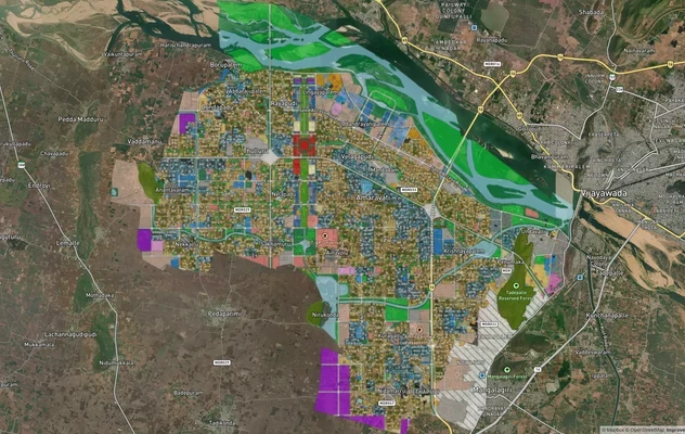
Amaravati APCRDA Masterplan 2050: Zone Check and Land Use Guide
View Amaravati Masterplan as a live map overlay – check any plot's land use zone for free on 1acre.in. APCRDA masterplan...
Kakinada Masterplan: Zone Check and Land Use Guide
View Kakinada Masterplan as a live map overlay – check any plot's land use zone for free on 1acre.in. Kakinada masterpla...
Tirupati TUDA Masterplan: Zone Check and Land Use Guide
View Tirupati Masterplan as a live map overlay – check any plot's land use zone for free on 1acre.in. Tirupati TUDA mast...
More Layers in Andhra Pradesh
Amaravati APCRDA Masterplan 2050: Zone Check and Land Use Guide
View Amaravati Masterplan as a live map overlay – check any plot's land use zone for free on 1acre.in. APCRDA masterplan...
Kakinada Masterplan: Zone Check and Land Use Guide
View Kakinada Masterplan as a live map overlay – check any plot's land use zone for free on 1acre.in. Kakinada masterpla...
Tirupati TUDA Masterplan: Zone Check and Land Use Guide
View Tirupati Masterplan as a live map overlay – check any plot's land use zone for free on 1acre.in. Tirupati TUDA mast...