Mumbai Development Plan 2034: Zone Check and Land Use Guide
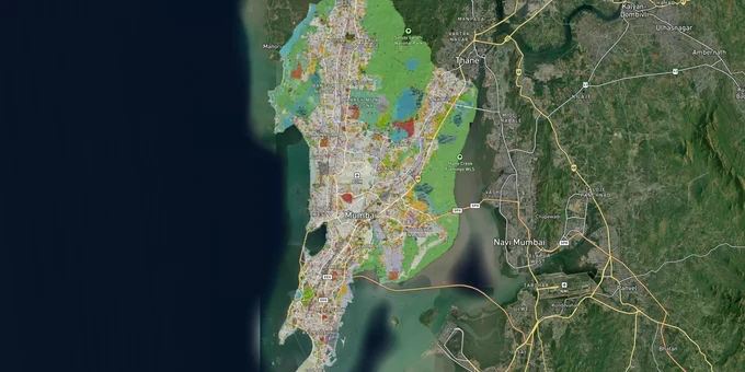
Mumbai Masterplan Preview
Try the Mumbai Development Plan 2034 on the map
Sign in once and explore the layer for a full day.
- No card details needed
- Find nearby verified lands for sale
Overview
The Greater Mumbai Development Plan 2034 is the statutory land-use blueprint for all 24 wards of Greater Mumbai, prepared by the Municipal Corporation of Greater Mumbai (MCGM) — the Planning Authority for Greater Mumbai under the MRTP Act, 1966, and sanctioned by the State Government on 8 May 2018. Every parcel in this city sits inside a zone code that determines FSI entitlement, TDR access, and whether construction is permissible at all. Verifying your Mumbai masterplan 2034 zone before any transaction is the single step that separates a viable deal from a frozen one. This page covers the critical regulatory traps, the corridors where DP 2034 zone classification directly affects land value, and how to use 1acre's tools to verify a plot remotely.
Reserved Plots and FSI Traps: The Two Mumbai DP 2034 Risks That Stop Projects Cold
Buying land in Mumbai without first confirming the Mumbai masterplan 2034 zone of the target parcel is the fastest way to lose six months and a lot of money. Two specific risks account for the majority of stalled transactions under DP 2034: undisclosed reservation codes and FSI miscalculation.
When a plot is marked for a public amenity, road, park, or open space under DP 2034, no residential or commercial construction is permitted until the reservation is legally lifted. A parcel coded ROS (Reserved Open Space) under DCPR 2034 allows only a security cabin, gardener's room, or toilet block. Nothing else. The Bombay High Court confirmed this in April 2025 (2025:BHC-OS:8963-DB): a 2022 amendment to Regulation 17(3)(D)(2) permits slum rehabilitation on ROS parcels above 500 sq m, but a strict floor of 35% open public space must be preserved in every approved scheme. Buyers who skip the official DP Remark document typically discover a reservation only when the building proposal is rejected by MCGM.
FSI miscalculation is equally damaging. Under DCPR 2034, permissible FSI across Greater Mumbai is not fixed by zone alone; it is tiered by the width of the road the plot abuts. The table below shows the range.
Area
Road Width
Base (Zonal) FSI
Maximum Base FSI (with Premium + TDR, excl. FCA)
Island City
Below 9m
1.33
1.33 (no additional FSI)
Island City
9m to 12m
1.33
2.00
Island City
18m to 27m
1.33
2.70
Suburbs
Below 9m
1.00
1.00 (no additional FSI)
Suburbs
9m to 12m
1.00
2.00
Suburbs
27m and above
1.00
2.50
An additional Fungible Compensatory Area (FCA) of up to 35% of permissible FSI is available on payment of a separate premium. A documented Andheri case saw a developer begin a housing project assuming an FSI of 2.5 on a road that did not meet the required width; the project was halted, and legal revision took over six months. If a broker cannot produce an official DP Remarks document matched to the CTS number of the plot, that FSI figure is guesswork.
Borivali to Eastern Suburbs: Where Mumbai Masterplan 2034 Zone Drives Investable Demand
The DP 2034 distributes zone value unevenly across Mumbai's three sub-regions. Island City carries high reservation density, Western Suburbs hold the strongest residential zone growth story, and Eastern Suburbs are where mixed-use parcels adjacent to rail corridors remain underpriced relative to incoming infrastructure.
In the Western Suburbs, Borivali and Malad sit inside residential zones where Metro Line 6 and Metro Line 7 alignments are actively shifting FSI ceilings upward along abutting roads widened for metro access. In the Eastern Suburbs, Metro Lines 9 and 10 serve corridors designed around Special Economic Zone growth. The Coastal Road Project reshapes frontage values along the western waterfront from Marine Lines northward, compressing supply in adjacent residential zones. Verifying the exact Mumbai masterplan 2034 zone for any corridor parcel requires overlaying the DP sheet, not relying on a broker's locality description.
The table below shows corridors where the DP 2034 zone classification intersects directly with confirmed infrastructure investment.
Corridor
Zone Profile
Key Infrastructure Driver
Buyer Risk
Andheri–Jogeshwari–Powai
Residential
Metro Line 6
Check for SGNP ESZ boundary overlap
Malad, Western Suburbs
Residential / Commercial
Metro Line 7
Confirm road width before calculating FSI ceiling
Eastern Suburbs
Mixed Residential / Industrial
Metro Lines 9 and 10
Industrial zone adjacency is possible on the CTS boundary
Island City waterfront
Residential / Commercial
Coastal Road Project
High reservation density; mandatory DP Remarks pull
Borivali is the most misread corridor. Plots marketed near Sanjay Gandhi National Park may overlap with the ESZ boundary delineated by Maharashtra's December 2016 notification. ESZ-1 parcels permit residential development in principle, but the DP 2034 zone and the ESZ classification must both be checked against the actual CTS number before any offer is made.
Was this layer helpful?
Anything wrong, outdated, or missing we want to hear it.
For Land Owners & Agents
Looking to sell your land in Maharashtra?
I want to sell my land in Maharashtra
10:32
Plz share your Land's location - We will list it on 1acre map, for Free.
10:32

For Land Buyers
Browse all verified lands & plots in Maharashtra
Every listing goes through our Preliminary Verification Process.
More Layers in Maharashtra
See all 32 layers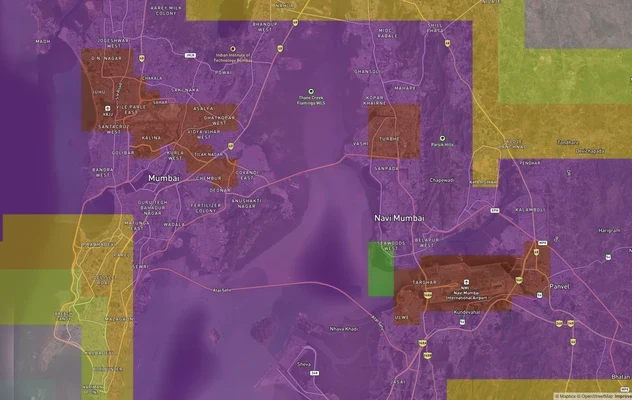
Mumbai Air Funnel Zones: Building Height Restrictions
View Mumbai Air Funnel Zones on a live map – check height clearance restrictions on any plot for free on 1acre.in. Mumba...
Mumbai Nagpur Samruddhi Mahamarg
View the Mumbai Nagpur Samruddhi Mahamarg corridor on a live map overlay – check NA conversion, NMRDA/NIT zone status an...
Nagpur Masterplan 2032: Zone Check and Land Use Guide
View Nagpur Masterplan as a live map overlay – check any plot's land use zone for free on 1acre.in. Nagpur Metropolitan ...
More Layers in Maharashtra
Mumbai Air Funnel Zones: Building Height Restrictions
View Mumbai Air Funnel Zones on a live map – check height clearance restrictions on any plot for free on 1acre.in. Mumba...
Mumbai Nagpur Samruddhi Mahamarg
View the Mumbai Nagpur Samruddhi Mahamarg corridor on a live map overlay – check NA conversion, NMRDA/NIT zone status an...
Nagpur Masterplan 2032: Zone Check and Land Use Guide
View Nagpur Masterplan as a live map overlay – check any plot's land use zone for free on 1acre.in. Nagpur Metropolitan ...