Mumbai Air Funnel Zones: Building Height Restrictions
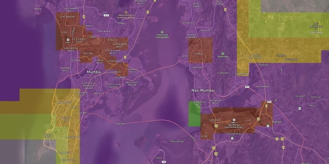
Mumbai Air Funnel Zones Preview
Try the Mumbai Air Funnel Zones on the map
Sign in once and explore the layer for a full day.
- No card details needed
- Find nearby verified lands for sale
Overview
Mumbai airport funnel zone restrictions are among the most consequential in India. The color coded zoning map for Mumbai and Navi Mumbai, published by AAI under Gazette of India Statutory Rules (GSR) 751(E), 2015 and updated in June 2016, governs permissible building height across a 20 km radius of Chhatrapati Shivaji Maharaj International Airport. The airport sits in Vile Parle East at 14 m above mean sea level (AMSL) and operates two intersecting runways: the primary runway 09/27 (3,445 m) and the secondary runway 14/32 (2,871 m). At 4 km from the airport, buildings above just 17.87 m require AAI approval, the lowest threshold of any major Indian city.
Why Mumbai's Colour Coded Zoning Map (CCZM) Bites Harder Than Any Other Indian City's
Mumbai is the sharpest example of what happens when an airport is embedded inside a dense urban core. The funnel zone has been in place since 1928, virtually covering 50% of suburban Mumbai, including Vile Parle, Andheri, Kurla, and Santacruz. In Navi Mumbai, 65% of the area, including Ulwe, Chinchpada, Khandeshwar, and Mansarovar, falls inside the funnel zone of the upcoming Navi Mumbai International Airport (IATA: NMI, ICAO: VANM), which commenced commercial operations on 25 December 2025.
Permitted Building Heights by Funnel Zone Surface
The table below shows how permitted building height thresholds in Mumbai compare to the funnel zone structure across the key obstacle limitation surfaces around runway 09/27.
Zone Type
Distance from CSIA Runway
Mumbai Height Threshold
AAI NOC Required?
Approach / Funnel Surface
Along runway 09/27 axis, up to ~9 km
2% of distance from runway edge
Mandatory in all cases
Inner Horizontal Surface
Within ~4 km of runway ends
17.87 m (approx. 5–6 floors)
Yes, above this threshold
Conical Surface
4–15 km from Aerodrome Reference Point (ARP)
Rises gradually; varies by grid
Depends on CCZM grid colour
Outer Zone
15–20 km from ARP
More permissive; local MCGM bylaws
Required only if building exceeds CCZM PTE
The 17.87 m threshold at 4 km is the number every buyer must carry. In Vijayawada, the same distance from the airport allows buildings up to 42.14 m before AAI approval is needed. In Mumbai, a five- to six-story building triggers a mandatory NOC. The old AAI ATC tower at CSIA itself was demolished in 2014 because it penetrated runway 14/32's transitional obstacle limitation surfaces by over 50 meters. If AAI acted against its own infrastructure for a height violation, it will act against yours. Confirm the CCZM grid color and permitted top elevation for your plot before you approach any lender or sign any agreement.
Santacruz to Ulwe: Where Mumbai's Funnel Zone Suppresses Value and Where It Creates Opportunity
Mumbai's funnel zone is not a uniform constraint. It creates a specific set of winners and losers depending on where you are and what you intend to build. The Maharashtra government's April 2025 amendment to DCPR-2034 introduced Transferable Development Rights (TDR) for funnel zone redevelopment, reported to affect an estimated 6,000 buildings and 3.5 lakh tenants (figures cited in media coverage of the amendment; primary notification text does not cite specific building counts) in Vile Parle, Santacruz, Kurla, and Ghatkopar.
The table below maps key Mumbai and Navi Mumbai corridors against their funnel zone constraint profile.
Corridor / Locality
Airport Distance
Constraint Level
Growth Driver
Key Risk
Vile Parle / Santacruz
0-3 km (immediate vicinity, CSIA)
Very High (approach funnel)
Metro Line 3 access; established residential demand
Height cap at ~17.87 m; redevelopment relies on TDR under DCPR-2034
Andheri / Kurla
2-6 km (CSIA zone)
High
BKC adjacency; commercial corridor
AAI towers in Andheri under relocation; check individual grid before buying
Ghatkopar
~8-10 km (southeast of CSIA)
Moderate
Metro Line 1 hub; eastern suburbs growth
Conical surface zone; Floor Space Index (FSI) up to 2.7 but TDR may be needed for full utilisation
Ulwe / Panvel
0-5 km (NMIA approach, runway 08/26)
Very High (new airport, northeast-southwest approach)
NMIA opened December 2025; Atal Setu / MTHL connectivity
CCZM for NMIA not yet aligned with full build-out; verify plot-level grid before committing
Khandeshwar / Mansarovar (Navi Mumbai)
5-12 km (NMIA zone)
Moderate to High
Affordable entry point; Harbour Line access
65% of Navi Mumbai area within NMIA funnel zone; no historical CCZM precedent for this airport
The most consequential corridor right now is Ulwe and the surrounding Navi Mumbai nodes within 5 km of NMIA. The airport opened for commercial operations on 25 December 2025. Its single runway 08/26 is oriented northeast-southwest, meaning the approach funnel cuts across a different axis from the CSIA funnel. AAI restricted 150 approved projects in Navi Mumbai to just 55 m height during the pre-operational planning period, and that ceiling covered developments from Nerul to Panvel. Buyers purchasing land near NMIA today without checking the current CCZM grid face the same regulatory surprise that CSIA buyers encountered for decades.
Was this layer helpful?
Anything wrong, outdated, or missing we want to hear it.
For Land Owners & Agents
Looking to sell your land in Maharashtra?
I want to sell my land in Maharashtra
10:32
Plz share your Land's location - We will list it on 1acre map, for Free.
10:32

For Land Buyers
Browse all verified lands & plots in Maharashtra
Every listing goes through our Preliminary Verification Process.
More Layers in Maharashtra
See all 32 layers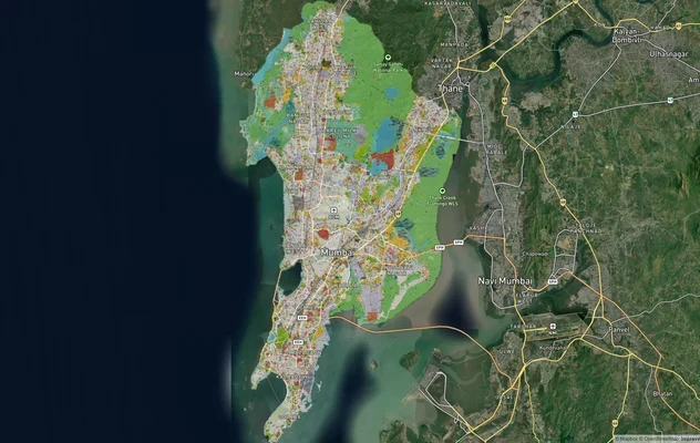
Mumbai Development Plan 2034: Zone Check and Land Use Guide
View Mumbai Masterplan as a live map overlay – check any plot's land use zone for free on 1acre.in. Mumbai masterplan 20...
Mumbai Nagpur Samruddhi Mahamarg
View the Mumbai Nagpur Samruddhi Mahamarg corridor on a live map overlay – check NA conversion, NMRDA/NIT zone status an...
Nagpur Masterplan 2032: Zone Check and Land Use Guide
View Nagpur Masterplan as a live map overlay – check any plot's land use zone for free on 1acre.in. Nagpur Metropolitan ...
More Layers in Maharashtra
Mumbai Development Plan 2034: Zone Check and Land Use Guide
View Mumbai Masterplan as a live map overlay – check any plot's land use zone for free on 1acre.in. Mumbai masterplan 20...
Mumbai Nagpur Samruddhi Mahamarg
View the Mumbai Nagpur Samruddhi Mahamarg corridor on a live map overlay – check NA conversion, NMRDA/NIT zone status an...
Nagpur Masterplan 2032: Zone Check and Land Use Guide
View Nagpur Masterplan as a live map overlay – check any plot's land use zone for free on 1acre.in. Nagpur Metropolitan ...