Madh Versova Bridge

Madh Versova Bridge Preview
Try the Madh Versova Bridge on the map
Sign in once and explore the layer for a full day.
- No card details needed
- Find nearby verified lands for sale
Overview
A cable stayed connector spanning just over two kilometers will link Madh Jetty with Versova Koliwada by early 2029, targeted by BMC to cut travel time from 90 minutes to approximately 10 minutes once operational. The Brihanmumbai Municipal Corporation started ground surveys last month after securing partial environmental approvals in mid-2025. Right now, anyone traveling between these two neighborhoods must loop 22 kilometers through choked arterials. This infrastructure layer marks where the alignment crosses Versova Creek, flagging which land parcels sit inside the value uplift zone.
Regulatory Bottlenecks That Could Delay Your Investment Window
Two permissions still missing: forest department sign-off and a green light from Bombay High Court. Without both, no concrete gets poured. The Municipal Corporation received conditional environmental nod from the central ministry seven months ago, but that approval means nothing until the final two clearances land.
Here's what tripped up the project before. Back in early 2022, the state coastal authority rejected BMC's first route because it would have sliced through prime mangrove patches. Fishing families from both creek banks protested, saying the original design would strand their boats. The civic body went back, redrew the alignment, and got coastal clearance in February 2023 for the second version.
Approval Stage
Current Position
What Stops Construction
Central environment ministry
Granted July 2025
None, this one's done
State coastal authority
Approved Feb 2023
None, already cleared
Forest department Stage II
Still pending
Mangrove impact study review
High Court final order
Still pending
Environmental litigation
This project sat on paper since 1967. Contractors got selected in September 2024. Survey teams only showed up in December 2025. If the court drags its feet past March 2026, every month of delay pushes completion further from the 2029 target. Smart land buyers are watching those two pending files, not the promotional renderings.
Sub-Market Pricing Snapshot Along the Madh-Versova Bridge Corridor
Brokers tracking Madh Island transactions say rates could climb anywhere from one-quarter to half again their current levels once digging starts. Flats in Madh trade around 25,000 to 35,000 rupees per square foot today. Versova commands 35,000 to 45,000 for similar stock. Once the bridge operates, expect Madh pricing to match or beat Versova, especially beachfront inventory.
What It Costs Now
Madh seafront plots
28k to 35k per sq ft
Madh Marve approach
22k to 28k per sq ft
Versova village edge
38k to 45k per sq ft
Aksa belt near Malad
18k to 25k per sq ft
What It Costs Now
Madh seafront plots
28k to 35k per sq ft
Madh Marve approach
22k to 28k per sq ft
Versova village edge
38k to 45k per sq ft
Aksa belt near Malad
18k to 25k per sq ft
Madh Island and the Madh–Marve corridor remain ferry-dependent today, with creek crossings suspended for roughly four months a year during monsoon. The bridge changes the access profile rather than the regulatory regime — CRZ-II restrictions, BMC building permission requirements, and Forest Department conditions continue to govern construction on individual plots.
Was this layer helpful?
Anything wrong, outdated, or missing we want to hear it.
For Land Owners & Agents
Looking to sell your land in Maharashtra?
I want to sell my land in Maharashtra
10:32
Plz share your Land's location - We will list it on 1acre map, for Free.
10:32

For Land Buyers
Browse all verified lands & plots in Maharashtra
Every listing goes through our Preliminary Verification Process.
More Layers in Maharashtra
See all 32 layers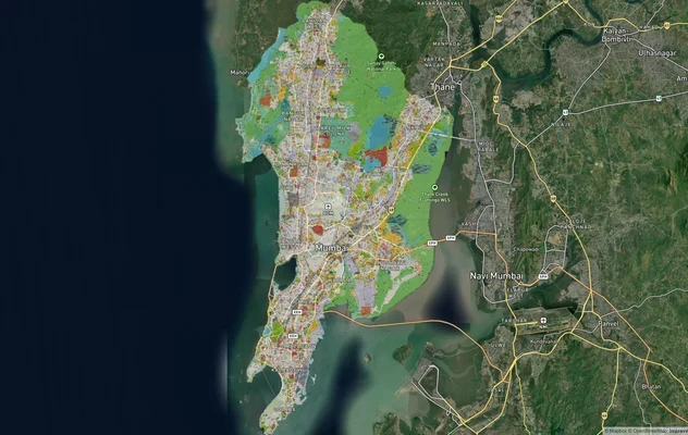
Mumbai Development Plan 2034: Zone Check and Land Use Guide
View Mumbai Masterplan as a live map overlay – check any plot's land use zone for free on 1acre.in. Mumbai masterplan 20...
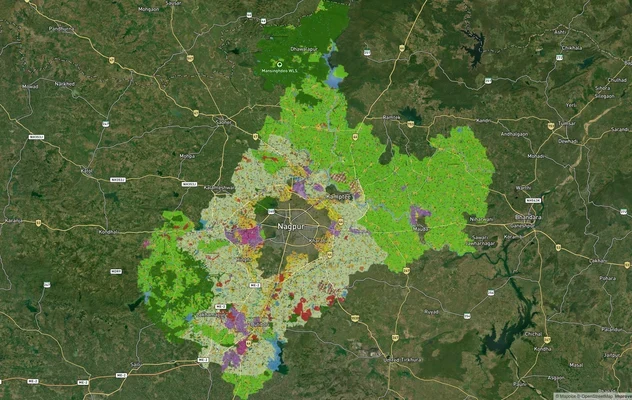
Nagpur Masterplan 2032: Zone Check and Land Use Guide
View Nagpur Masterplan as a live map overlay – check any plot's land use zone for free on 1acre.in. Nagpur Metropolitan ...
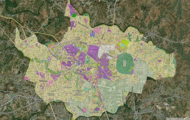
Pimpri Chinchwad PCMC Masterplan: Zone Check and Land Use Guide
View Pimpri Chinchwad Masterplan as a live map overlay – check any plot's land use zone for free on 1acre.in. Pimpri Chi...
More Layers in Maharashtra
Mumbai Development Plan 2034: Zone Check and Land Use Guide
View Mumbai Masterplan as a live map overlay – check any plot's land use zone for free on 1acre.in. Mumbai masterplan 20...
Nagpur Masterplan 2032: Zone Check and Land Use Guide
View Nagpur Masterplan as a live map overlay – check any plot's land use zone for free on 1acre.in. Nagpur Metropolitan ...
Pimpri Chinchwad PCMC Masterplan: Zone Check and Land Use Guide
View Pimpri Chinchwad Masterplan as a live map overlay – check any plot's land use zone for free on 1acre.in. Pimpri Chi...