Virar Alibaug Multimodal Corridor

Virar Alibaug Multimodal Corridor Preview
Try the Virar Alibaug Multimodal Corridor on the map
Sign in once and explore the layer for a full day.
- No card details needed
- Find nearby verified lands for sale
Overview
The Virar Alibaug multimodal corridor is a 126 km project that could connect Virar to Alibaug in approximately 1.5 to 2 hours instead of the current four-plus hours. Think road, rail, and even a ferry service cutting across coastal Maharashtra. The Detailed Project Report sits with MMRDA waiting for approvals that haven't arrived yet. This layer marks where the route might go based on that DPR. Here's the problem: land along this corridor is being sold at inflated prices for a project that has no clearances, no land acquisition notices, and no confirmed timeline. This page tells you what's real, what's speculation, and where brokers are running outright scams.
Fake Maps and the Alignment Nobody Can Confirm
Brokers love this corridor because nobody can prove them wrong yet. The DPR doesn't list specific survey numbers.
You'll see printouts showing your plot falls right in the alignment path. Most of these maps are fabricated. The official DPR divides the route into three segments: Virar to Panvel at 52 km, Panvel to Revdanda at 48 km, and Revdanda to Alibaug at 26 km. None of these segments have started land acquisition. Not one survey number has a government notice attached to it. If a broker shows you a map with your survey number circled in red, ask for the acquisition notification number. They won't have it.
Fraud Pattern
What Brokers Claim
What's Actually True
Alignment certainty
This survey number is confirmed in the route
DPR shows corridor zones, not specific survey numbers
Influence zone pricing
Land within 300 meters gets automatic value jump
No official influence zone defined in any government document
Approval status
Project is approved, just waiting for funds
Missing forest clearance, Coastal Regulation Zone (CRZ) clearance, land notifications
Compensation rates
Government will pay 4x market rate for acquisition
No acquisition process started, no rates announced
The worst scam involves something called the influence zone. Brokers claim any land within 300 meters of the proposed route will see automatic appreciation. There is no such zone in the DPR or any MMRDA notification. If someone uses this term, you're being misled.
Where the Real Bets Are Being Placed
Five areas are seeing serious land speculation. Only two make sense if the corridor never happens.
Virar East and Vasai East already have trains running to Mumbai. Land there has other reasons to hold value. Manor and Mahim in Palghar are pure bets on the corridor with zero backup plan. Pen and Revdanda face coastal regulation nightmares that could kill parts of the project before a single brick gets laid. If you're buying in Manor and the corridor gets shelved, you own agricultural land with no conversion path and no connectivity.
Area
What Works Today
Why People Are Buying
The Catch
Virar East
Suburban trains to Churchgate
Spillover demand from Vasai
Already priced high, limited upside left
Vasai East
Western Railway plus IT park coming up
Job creation independent of corridor
Conversion applications backlogged 18 months
Manor
Nothing
Believed to be corridor midpoint
No masterplan coverage, agricultural use only
Pen
State Highway 4 access
Equidistant from both ends
CRZ buffer could block alignment changes
Revdanda
Small ferry service to Gateway
Proposed waterway terminal location
Terminal site is in CRZ-I restricted zone
Revdanda is where the project could collapse. The ferry terminal they're planning sits in a CRZ-I zone where construction is mostly banned. The clearance application has been pending since 2023 with no movement. Anyone buying land in Revdanda betting on that terminal is gambling on an approval that coastal regulators rarely give.
Was this layer helpful?
Anything wrong, outdated, or missing we want to hear it.
For Land Owners & Agents
Looking to sell your land in Maharashtra?
I want to sell my land in Mumbai
10:32
Plz share your Land's location - We will list it on 1acre map, for Free.
10:32

For Land Buyers
Browse all verified lands & plots in Maharashtra
Every listing goes through our Preliminary Verification Process.
More Layers in Maharashtra
See all 32 layers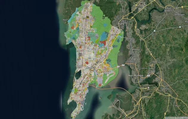
Mumbai Development Plan 2034: Zone Check and Land Use Guide
View Mumbai Masterplan as a live map overlay – check any plot's land use zone for free on 1acre.in. Mumbai masterplan 20...
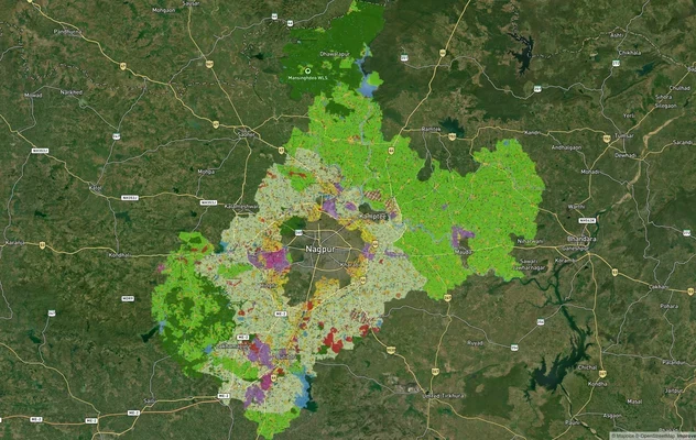
Nagpur Masterplan 2032: Zone Check and Land Use Guide
View Nagpur Masterplan as a live map overlay – check any plot's land use zone for free on 1acre.in. Nagpur Metropolitan ...
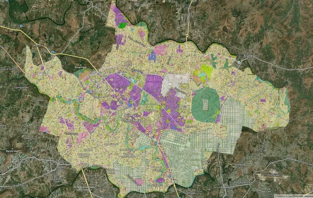
Pimpri Chinchwad PCMC Masterplan: Zone Check and Land Use Guide
View Pimpri Chinchwad Masterplan as a live map overlay – check any plot's land use zone for free on 1acre.in. Pimpri Chi...
More Layers in Maharashtra
Mumbai Development Plan 2034: Zone Check and Land Use Guide
View Mumbai Masterplan as a live map overlay – check any plot's land use zone for free on 1acre.in. Mumbai masterplan 20...
Nagpur Masterplan 2032: Zone Check and Land Use Guide
View Nagpur Masterplan as a live map overlay – check any plot's land use zone for free on 1acre.in. Nagpur Metropolitan ...
Pimpri Chinchwad PCMC Masterplan: Zone Check and Land Use Guide
View Pimpri Chinchwad Masterplan as a live map overlay – check any plot's land use zone for free on 1acre.in. Pimpri Chi...