Nagpur Air Funnel Zones: Building Height Restrictions
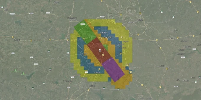
Nagpur Air Funnel Zones Preview
Try the Nagpur Air Funnel Zones on the map
Sign in once and explore the layer for a full day.
- No card details needed
- Find nearby verified lands for sale
Overview
Nagpur airport funnel zone restrictions govern permissible building heights across a 20-km radius around Dr. Babasaheb Ambedkar International Airport. Issued under the Ministry of Civil Aviation's Height Restrictions Rules 2015, these rules are enforced by AAI through its Colour Coded Zoning Map (CCZM). Any structure above 15 meters AGL requires a height NOC via the NOCAS portal before construction. This page covers how to read the CCZM for Nagpur, which corridors face the strictest height caps, and the documents you must verify before signing any land deal near the airport.
Height Restriction Traps That Have Killed Nagpur Real Estate Projects
Funnel zones aligned with runway ends impose the harshest height limits, and they catch buyers off guard because sellers rarely disclose them. In Nagpur's MIHAN SEZ, a developer who planned 18-storey towers inside the SEZ saw AAI curtail the heights because the site sat inside the aircraft landing funnel, floors that were approved by MADC were blocked by AAI.
The CCZM for Nagpur divides the area around the airport into colour-coded grids, each carrying a Permissible Top Elevation (PTE) in metres AMSL. The table below shows how each colour grade translates into construction risk.
CCZM Colour
Meaning
Construction Route
Red Grid
Site falls inside strict restriction zone
File NOC directly with AAI via NOCAS, no local body approval
Non-Red Grid below PTE
Site elevation plus proposed height is under PTE
Local body (NMC/NIT/NMRDA) can approve without AAI referral
Any grid, structure above 150 m AMSL
Above CCZM auto-settle threshold
Must apply to AAI via NOCAS regardless of colour
Funnel Zone (runway axis)
Height = 2% of distance from runway edge
Strictest zone; a plot 1,000 m from runway end has a 20 m height cap
The formula is simple but deadly: if a broker quotes you the Floor Space Index (FSI) without first checking the CCZM grid and subtracting site elevation from the PTE, you are being sold a number that may be legally unreachable. If your Nagpur airport height restriction NOC check reveals a red grid, the local body cannot issue a construction permit, only AAI can.
MIHAN, Jamtha, Besa and Wardha Road: Which Corridors Have Room and Which Don't
South Nagpur's growth corridors are the most active land investment zones in the city, and they all sit inside AAI's 20-km NOC radius.
The table below maps the four key corridors to their investment profile and height risk.
Corridor
Distance from Airport ARP
Zone Character
Height Risk
Best Use
MIHAN SEZ core
0-4 km
Industrial / IT
Very High, partially in funnel
Industrial plots with MADC approval only
Jamtha
3-6 km
Residential / Mixed
High, within conical surface
Low-rise residential, NMRDA-approved layouts
Besa-Pipla
6-9 km
Established residential
Moderate
Mid-rise residential, NMRDA-sanctioned
Wardha Road (outer)
9-14 km
Commercial / Residential
Low to Moderate
Plotted townships, commercial layouts
Jamtha is one of Nagpur's most active plot markets, but buyers regularly ignore that it sits inside the conical surface zone, where heights slope upward at 5% gradient from the airport perimeter. A layout sanctioned by NMRDA for G+3 floors can still be blocked at the construction permit stage if the CCZM PTE for that grid is lower than the proposed top elevation. Wardha Road's outer belt, beyond 10 km from the Aerodrome Reference Point, faces the most relaxed restrictions and is where NMRDA-approved layouts can typically achieve full permitted FSI without AAI referral.
Was this layer helpful?
Anything wrong, outdated, or missing we want to hear it.
For Land Owners & Agents
Looking to sell your land in Maharashtra?
I want to sell my land in Maharashtra
10:32
Plz share your Land's location - We will list it on 1acre map, for Free.
10:32

For Land Buyers
Browse all verified lands & plots in Maharashtra
Every listing goes through our Preliminary Verification Process.
More Layers in Maharashtra
See all 32 layers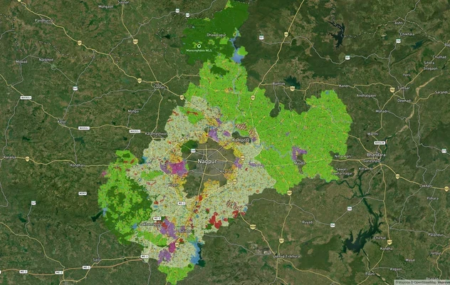
Nagpur Masterplan 2032: Zone Check and Land Use Guide
View Nagpur Masterplan as a live map overlay – check any plot's land use zone for free on 1acre.in. Nagpur Metropolitan ...
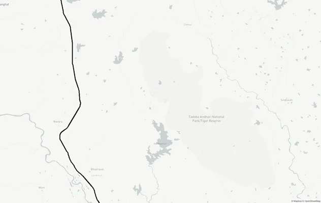
Nagpur Chandrapur Expressway
View Nagpur Chandrapur Expressway alignment as a live map overlay – check land acquisition risk and plot proximity free ...
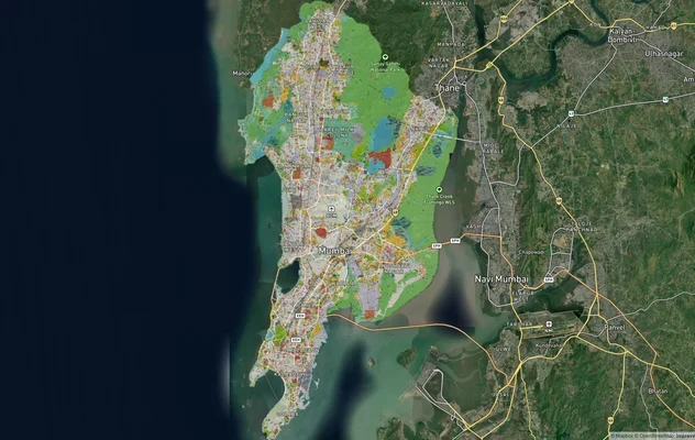
Mumbai Development Plan 2034: Zone Check and Land Use Guide
View Mumbai Masterplan as a live map overlay – check any plot's land use zone for free on 1acre.in. Mumbai masterplan 20...
More Layers in Maharashtra
Nagpur Masterplan 2032: Zone Check and Land Use Guide
View Nagpur Masterplan as a live map overlay – check any plot's land use zone for free on 1acre.in. Nagpur Metropolitan ...
Nagpur Chandrapur Expressway
View Nagpur Chandrapur Expressway alignment as a live map overlay – check land acquisition risk and plot proximity free ...
Mumbai Development Plan 2034: Zone Check and Land Use Guide
View Mumbai Masterplan as a live map overlay – check any plot's land use zone for free on 1acre.in. Mumbai masterplan 20...