Pune Ring Roads: Route Alignment and Land Impact
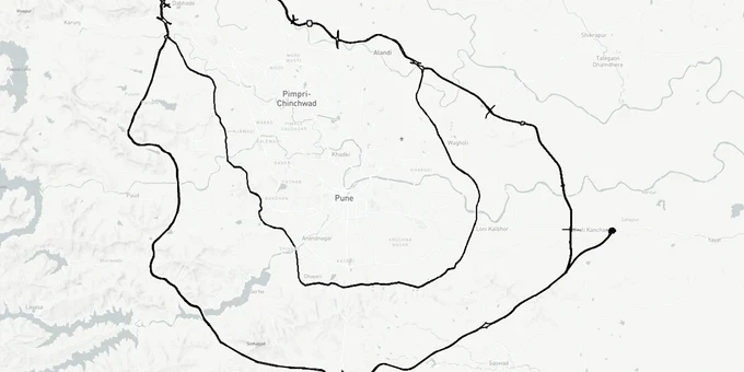
Pune Ring Roads Preview
Try the Pune Ring Roads on the map
Sign in once and explore the layer for a full day.
- No card details needed
- Find nearby verified lands for sale
Overview
The Pune Ring Road is not one project. It is two concentric expressways built by two separate authorities, and confusing them is the first mistake buyers near the alignment make. The PMRDA Inner Ring Road covers 83.12 km through 44 villages across Khed, Haveli, Mulshi, and Maval talukas, with land acquisition at an early stage. The MSRDC Outer Ring Road spans ~173 km (Eastern 71.35 km + Western 65.45 km, plus realignment additions per Oct 2025 update) across 83 villages; construction officially commenced in May 2025 with 99% of western-phase land acquired. Together, these corridors connect all six major highways around Pune, targeting operational completion by late 2027 to 2030 depending on the project. This page covers what each road means for Pune Ring Road land buying, which villages carry acquisition risk, and where the documented fraud patterns are.
Why Buying a Plot on the Pune Ring Road Alignment Without Checking the 7/12 Extract First Is a Documented Fraud Risk
Brokers in Wagholi, Holkarwadi, and Chakan have been actively selling plots described as "ring road-facing" or "just outside the acquisition zone." Several are neither. The specific fraud pattern documented across police cases in 2024 and 2025 involves land sold in layouts where the title is under another entity's ownership, the sale restriction is in force, or the survey number sits squarely inside MSRDC's notified acquisition zone. In the Wagholi Arohi Park case registered at Lonikand police station, buyers paid Rs 2.8 crore for plots in a layout whose seller had no clear title; the names were never entered in the 7/12 extract (Satbara Utara). A parallel Rs 4.16 crore fraud in Wagholi and Kharadi involved false promises of land delivery to buyers who never received either land or refund.
The risk specific to the ring road alignment is this: land inside or immediately adjacent to MSRDC's notified acquisition zone carries a restriction on transfer. Once MSRDC initiates acquisition proceedings for a survey number, private sale of that land without disclosure of the government interest is irregular at best and fraudulent at worst. Compensation is paid to the title holder as of the notification date; a buyer who purchases after that date may have no legal standing to claim it.
The table below identifies the key document checks before any purchase near the ring road alignment.
Document
What to Check
Red Flag
7/12 Extract (Satbara Utara)
Title holder's name, encumbrances, mutation entries
Name of buyer not mutated after registration
MSRDC Acquisition Notification
Whether survey number is in notified list
Broker cannot show this document
NA Order / Non-Agricultural permission
Whether land has been converted from agricultural
No NA order means residential plot sale is irregular
Sale restriction status
Whether any court or government order bars transfer
Any restriction entry in Col. 6 of 7/12
If a broker cannot show you the 7/12 for the specific survey number and confirm it is outside MSRDC's notified acquisition boundary, that plot should be avoided.
Wagholi, Chakan, Hinjewadi, and Holkarwadi: Ring Road Corridor Status and Buyer Risks
Not every location along Pune Ring Road's 83-village alignment is the same investment proposition. The distinction that matters is between corridors where appreciation is already supported by construction momentum, and corridors where it is purely speculative because PMRDA land acquisition is still below 25%.
Suburbs including Hinjewadi, Wagholi, and Kharadi have recorded annual price increases of 12 to 18% since the project announcement; Wagholi and peripheral areas like Chakan and Uruli Kanchan are projected to see a further 10 to 15% appreciation once construction progresses. The Bhosari–Chakan–Ranjangaon industrial corridor has seen warehouse leasing volumes rise 25% annually since 2024, driven directly by the road's logistics connectivity promise. PMRDA's planned Mhalunge–Mann township spans 700 acres, while two additional townships at Holkarwadi across 500 acres are intended to bring residential units 30 to 40% below central Pune prices.
The table below maps four corridors to their current risk and opportunity profile.
Corridor
Ring Road Benefit
Construction Status
Buyer Risk Level
Wagholi / Kesnand (Phase 1 East)
Direct alignment; Pune-Ahmednagar Road access
MSRDC construction commenced May 2025
Moderate (active fraud cases; verify 7/12 carefully)
Chakan / Ranjangaon (North)
Logistics corridor; Pune-Nashik Highway link
MSRDC work underway
Low-Moderate
Hinjewadi / Pirangut (West)
Western corridor; Expressway junction
Construction active
Moderate (PMRDA acquisition lag in parts)
Holkarwadi / Vadachiwadi (South-East)
PMRDA township zone
PMRDA acquisition early stage (24% in some pockets)
Higher (long timeline; check acquisition status)
The most misunderstood corridor is Holkarwadi. PMRDA has announced two townships there on 500 acres. That announcement is genuine. What buyers are not told is that PMRDA's land acquisition in Wagholi, Vadachiwadi, and Kadambavasti was at 24% as of the latest confirmed figures, meaning the township timeline remains long and uncertain. Entry at current prices purely on the township promise carries meaningful execution risk.
Was this layer helpful?
Anything wrong, outdated, or missing we want to hear it.
For Land Owners & Agents
Looking to sell your land in Maharashtra?
I want to sell my land in Maharashtra
10:32
Plz share your Land's location - We will list it on 1acre map, for Free.
10:32

For Land Buyers
Browse all verified lands & plots in Maharashtra
Every listing goes through our Preliminary Verification Process.
More Layers in Maharashtra
See all 32 layers
Mumbai Development Plan 2034: Zone Check and Land Use Guide
View Mumbai Masterplan as a live map overlay – check any plot's land use zone for free on 1acre.in. Mumbai masterplan 20...
Nagpur Masterplan 2032: Zone Check and Land Use Guide
View Nagpur Masterplan as a live map overlay – check any plot's land use zone for free on 1acre.in. Nagpur Metropolitan ...
Pimpri Chinchwad PCMC Masterplan: Zone Check and Land Use Guide
View Pimpri Chinchwad Masterplan as a live map overlay – check any plot's land use zone for free on 1acre.in. Pimpri Chi...
More Layers in Maharashtra
Mumbai Development Plan 2034: Zone Check and Land Use Guide
View Mumbai Masterplan as a live map overlay – check any plot's land use zone for free on 1acre.in. Mumbai masterplan 20...
Nagpur Masterplan 2032: Zone Check and Land Use Guide
View Nagpur Masterplan as a live map overlay – check any plot's land use zone for free on 1acre.in. Nagpur Metropolitan ...
Pimpri Chinchwad PCMC Masterplan: Zone Check and Land Use Guide
View Pimpri Chinchwad Masterplan as a live map overlay – check any plot's land use zone for free on 1acre.in. Pimpri Chi...