Nagpur Masterplan 2032: Zone Check and Land Use Guide
Nagpur Masterplan Preview
Try the Nagpur Masterplan 2032 on the map
Sign in once and explore the layer for a full day.
- No card details needed
- Find nearby verified lands for sale
Overview
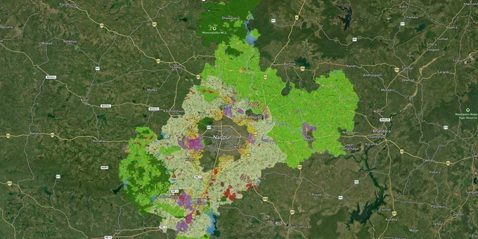
The Nagpur Metropolitan Area Masterplan 2032 is the operative land-use framework for 3,567 sq km covering 721 villages across 9 tehsils of Nagpur District, administered by the Nagpur Metropolitan Region Development Authority (NMRDA) under the Maharashtra Regional and Town Planning Act, 1966. The plan was prepared by the Nagpur Improvement Trust (NIT) as the Special Planning Authority, with Development Control and Promotion Regulations notified in 2018. It classifies land into residential, commercial, industrial, agricultural, public utility, and forest zones. Checking a plot's zone under the Nagpur Metropolitan Area Masterplan 2032 before purchase is the first and most consequential step for any buyer in this region.
Agriculture A1/A2 zones and the Release Letter trap that catches Nagpur plot buyers
Most land within NMRDA's 3,567 sq km starts as agricultural. The NIT Proposed Land Use map distinguishes between Agriculture A1 and Agriculture A2 zones, alongside forest, defense, mines and quarries, recreation and open space, transportation, and public utility. A plot marketed as residential in the NMRDA area is only legally so after formal NA (non-agricultural) conversion and NMRDA layout sanction. Neither a 7/12 extract showing NA status nor a developer's brochure claiming NMRDA approval is sufficient on its own.
Document Checklist: What to Verify Before Buying
The second document buyers must demand is the Release Letter (RL). In every NMRDA-sanctioned layout, a portion of the plots is mortgaged to the authority until the developer completes the layout's development works. Registration of a plot without the RL is legally invalid. The table below sets out the four key document checks for any NMRDA-zone plot:
Document
What It Confirms
Risk If Missing
7/12 Extract
Current land classification and ownership
Cannot confirm if land is still agricultural
NA / Land Conversion Certificate
Agricultural land officially converted for non-agricultural use
Any construction is illegal; demolition risk
NMRDA Layout Sanction Letter
Layout plan approved under MRTP Act, 1966
Plot may be in unsanctioned area; no bank loan
Release Letter (RL)
Specific plot released from developer's mortgage to authority
Plot registration will be invalid
Only NMRDA-approved projects are eligible for home loans or plot loans from national and private banks; Gram Panchayat and unsanctioned NA plots fall outside this financing window entirely. If a broker cannot produce all four documents for a given survey number, the purchase carries legal risk regardless of location or price.
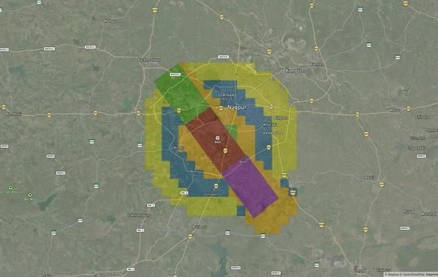
Wardha Road, MIHAN, Besa, and Hingna: what the Masterplan 2032 zone means for your plot value
The Nagpur Metropolitan Area Masterplan 2032 divides the metropolitan region into distinct growth bands, and the investment case for each depends entirely on the zone classification the plan assigns to that corridor. Plots in residential zones adjacent to the Outer Ring Road (ORR) or Samruddhi Mahamarg interchanges carry materially higher FSI potential and bank financing eligibility than agriculture-zoned land in the same taluk. The zone is not a detail; it is the entire decision.
The table below maps NMRDA's primary corridors against their dominant zone type and the key risk for buyers in each:
Corridor / Locality
Dominant Zone
Growth Driver
Primary Risk
Wardha Road (MIHAN, Jamtha, Butibori)
Residential / Industrial / SEZ
MIHAN SEZ, Nagpur International Airport, Samruddhi Mahamarg
AAI height restriction of 58 metres applies; verify before construction plan
Besa, Beltarodi, Pipla, Hudkeshwar
Residential
Established social infrastructure, Metro corridor proximity
Prices in prime Besa have peaked for budget investors; Release Letter (RL) availability critical
Hingna Road, Wadi, Amravati Road, Jaitala
Residential / Industrial Mix
Metro expansion towards Hingna, Hingna MIDC, Butibori MIDC
Agricultural land misrepresented as residential; verify zone on Masterplan map
Umred Road, Shankarpur, Mohgaon, Koradi Road
Residential (emerging)
Outer Ring Road connectivity, Samruddhi Highway feeder roads
Gram Panchayat plots common in this belt; ineligible for bank loans
The most misunderstood corridor is Umred Road and its feeder villages. Developers here frequently sell NATP (Non-Agricultural Town Planning) sanctioned plots under local bodies rather than NMRDA, at significantly lower price points. NATP sanction from a village-level authority is not equivalent to an NMRDA sanction; banks treat them differently, and construction permission follows a separate approval chain. A buyer comparing prices between an NMRDA-RL plot on Wardha Road and an NATP plot on Umred Road is not comparing equivalent legal products.
Was this layer helpful?
Anything wrong, outdated, or missing we want to hear it.
For Land Owners & Agents
Looking to sell your land in Maharashtra?
I want to sell my land in Maharashtra
10:32
Plz share your Land's location - We will list it on 1acre map, for Free.
10:32

For Land Buyers
Browse all verified lands & plots in Maharashtra
Every listing goes through our Preliminary Verification Process.
More Layers in Maharashtra
See all 32 layers
Nagpur Chandrapur Expressway
View Nagpur Chandrapur Expressway alignment as a live map overlay – check land acquisition risk and plot proximity free ...
Nagpur Air Funnel Zones: Building Height Restrictions
View Nagpur Air Funnel Zones on a live map – check height clearance restrictions on any plot for free on 1acre.in. Nagpu...
Mumbai Development Plan 2034: Zone Check and Land Use Guide
View Mumbai Masterplan as a live map overlay – check any plot's land use zone for free on 1acre.in. Mumbai masterplan 20...
More Layers in Maharashtra
Nagpur Chandrapur Expressway
View Nagpur Chandrapur Expressway alignment as a live map overlay – check land acquisition risk and plot proximity free ...
Nagpur Air Funnel Zones: Building Height Restrictions
View Nagpur Air Funnel Zones on a live map – check height clearance restrictions on any plot for free on 1acre.in. Nagpu...
Mumbai Development Plan 2034: Zone Check and Land Use Guide
View Mumbai Masterplan as a live map overlay – check any plot's land use zone for free on 1acre.in. Mumbai masterplan 20...