Nagpur Chandrapur Expressway
Nagpur Chandrapur Expressway Preview
Try the Nagpur Chandrapur Expressway on the map
Sign in once and explore the layer for a full day.
- No card details needed
- Find nearby verified lands for sale
Overview
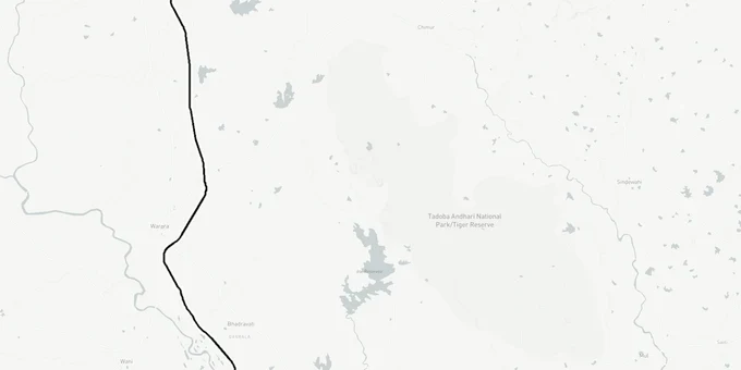
The Nagpur Chandrapur Expressway is a 204.8 km, four-lane access-controlled highway approved by the Cabinet Sub-Committee on Infrastructure on October 1, 2025, with the revised alignment cleared on December 9, 2025, with ₹2,353.94 crore sanctioned for land acquisition in February 2026. Built by MSRDC as a direct extension of the Samruddhi Mahamarg, it starts at the Seldoh Interchange and terminates at Navegaon More (Ghatkul), with an 11.969 km connector spur to Chandrapur city. The alignment passes through Nagpur Rural, Umred, Kuhi, Mauda, Bhandara, Mohadi, Tiroda, and Gondia talukas. This page covers the regulatory traps, active investment corridors, and critical document checks every buyer must run before transacting land near this route.
Alignment Changes Froze Earlier Transactions, Know the Current Boundary
The Nagpur Chandrapur Expressway alignment was not settled in a straight line from announcement to approval. The original alignment notified on December 27, 2023 was revised twice: first in October 2025 by the Cabinet Infrastructure Sub-Committee, and again in December 2025 following the Centre's Gati Shakti Portal review and objections from Western Coalfields Limited, the Forest Department, and wildlife activists over an existing tiger corridor. The December 2025 revision saved 27 hectares of forest land by shifting the trace. MSRDC cancelled its earlier 2024 tenders precisely because the alignment was unsettled and land acquisition timelines were unclear.
This revision history has one direct consequence for buyers: any layout marketed as "expressway-facing" or "highway touch" before December 2025 may reference a corridor that no longer exists at that location. Ask sellers for the GR notification dated December 9, 2025 or later, and cross-check the survey numbers against the revised alignment trace.
The table below shows the primary zones found along the Nagpur Chandrapur Expressway corridor per the NMRDA DCR 2018 and the MPCB EIA document.
Zone / Land Use
Status Under NMRDA DCR
Key Regulatory Rule
Agriculture A1
Cannot build without NA order
Collector permission required under MLRC 1966
Agriculture A2
Cannot build without NA order
Same NA conversion process; reclassification from A1 first needed
Forest / Eco-Sensitive
Prohibited for private purchase
Expressway alignment was revised to avoid this zone
Transportation Corridor
MSRDC acquisition zone
Compulsory acquisition; private transactions after Section 19(1) notice are void
Residential / Commercial (NMRDA approved)
Buildable with NMRDA sanction
7/12, B-extract, and sanctioned layout plan required
If a broker cannot show you the NMRDA sanction letter or a valid NA order with the Collector's signature for the specific survey number, do not proceed. A plain 7/12 extract showing "Sheti" (agricultural) use means the land has not been converted, any price premium baked in for "expressway proximity" is speculative until that conversion is formally granted.
Was this layer helpful?
Anything wrong, outdated, or missing we want to hear it.
For Land Owners & Agents
Looking to sell your land in Maharashtra?
I want to sell my land in Maharashtra
10:32
Plz share your Land's location - We will list it on 1acre map, for Free.
10:32

For Land Buyers
Browse all verified lands & plots in Maharashtra
Every listing goes through our Preliminary Verification Process.
More Layers in Maharashtra
See all 32 layers
Nagpur Masterplan 2032: Zone Check and Land Use Guide
View Nagpur Masterplan as a live map overlay – check any plot's land use zone for free on 1acre.in. Nagpur Metropolitan ...
Nagpur Air Funnel Zones: Building Height Restrictions
View Nagpur Air Funnel Zones on a live map – check height clearance restrictions on any plot for free on 1acre.in. Nagpu...
Mumbai Development Plan 2034: Zone Check and Land Use Guide
View Mumbai Masterplan as a live map overlay – check any plot's land use zone for free on 1acre.in. Mumbai masterplan 20...
More Layers in Maharashtra
Nagpur Masterplan 2032: Zone Check and Land Use Guide
View Nagpur Masterplan as a live map overlay – check any plot's land use zone for free on 1acre.in. Nagpur Metropolitan ...
Nagpur Air Funnel Zones: Building Height Restrictions
View Nagpur Air Funnel Zones on a live map – check height clearance restrictions on any plot for free on 1acre.in. Nagpu...
Mumbai Development Plan 2034: Zone Check and Land Use Guide
View Mumbai Masterplan as a live map overlay – check any plot's land use zone for free on 1acre.in. Mumbai masterplan 20...