Uttan Virar Sea Link
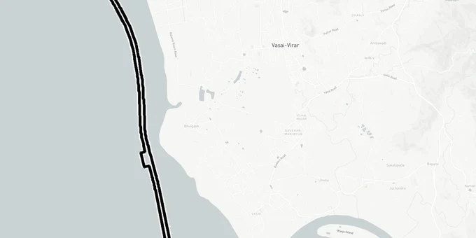
Uttan Virar Sea Link Preview
Try the Uttan Virar Sea Link on the map
Sign in once and explore the layer for a full day.
- No card details needed
- Find nearby verified lands for sale
Overview
The Uttan Virar Sea Link land investment story picked up real weight on 25 November 2025, when the Maharashtra government approved the DPR and released a Government Resolution committing Rs 58,754.71 crore for Phase 1. Implemented by MMRDA, the 55.12 km corridor comprises a 24.35 km sea bridge and 30.77 km of approach roads across Uttan, Vasai, and Virar. Originally proposed as the Versova-Virar Sea Link and rescoped to the current Uttan-Virar alignment in 2022.
Mangrove and CRZ Traps Buyers Are Missing Near the Uttan and Virar Connector Routes
The three connectors are where land buyers face the most danger, not the sea bridge itself. MMRDA is acquiring 208.6 hectares of private land for the connectors alone, and the alignment directly impacts 15.39 hectares of mangrove forest and 2.5 hectares of reserved forest inside the Tungareshwar Wildlife Sanctuary eco-sensitive zone near the Virar connector. Any plot sitting on or adjacent to that acquisition footprint is either already subject to a compensation award or legally restricted from development under Maharashtra's Coastal Regulation Zone rules.
The table below shows the three connector segments where private land acquisition is active or likely.
Connector
Length
Starting Point
Known Impact
Uttan connector
9.32 km
Interchange near Uttan Beach, links to Dahisar-Bhayandar Link Road
8.71 ha mangroves affected
Vasai connector
2.5 km
Vasai interchange
Least CRZ exposure of the three
Virar connector
18.95 km
Arnala beach, links to Delhi-Mumbai Expressway via 1.2 km Arnala Fort tunnel
6.68 ha mangroves affected; Tungareshwar eco-sensitive zone nearby
The mangrove boundary is the single most misrepresented fact in plots marketed near the Uttan and Virar connectors. Maharashtra law prohibits any construction within mangrove boundaries notified by the state government, and the Bombay High Court has historically been strict on mangrove encroachment. Before you pay any advance near Uttan beach or Arnala, verify the plot's distance from notified mangrove patches using the MCZMA official maps, not a broker's sketch. MCZMA cleared the UVSL project on 11 July 2025, with Union Ministry of Environment, Forests and Climate Change approval still pending as of April 2026.
Virar East, Naigaon, and Vasai Road: Which Pockets Are Most Directly Activated by the UVSL Corridor
The Virar connector is the longest at 18.95 km and ties directly into the Delhi-Mumbai Expressway at Virar interchange. That single connection is what drives Virar East's investment case, not sentiment. Naigaon and Vasai Road sit along the proposed Metro Line 13 (Purple Line) alignment, which is planned to run 23 km from Shivaji Chowk (Mira Road) to Virar. Line 13 remains at DPR stage; treat it as a planned, not active, driver.
The table below maps the four sub-markets most directly activated by the UVSL corridor, based on connector alignment and existing infrastructure.
Sub-market
UVSL Relevance
Additional Driver
Key Risk
Virar East
Direct endpoint, 18.95 km Virar connector terminating here
Delhi-Mumbai Expressway interchange
Mangrove and eco-sensitive zone proximity near Arnala
Uttan / Bhayandar
Origin point of sea bridge, 9.32 km Uttan connector
Dahisar-Bhayandar Link Road
Active private land acquisition underway, 208.6 ha total
Vasai Road
2.5 km Vasai connector on alignment
Bullet Train station at Virar, Metro Line 13
Least CRZ exposure; verify 7/12 for any creekside parcels
Naigaon
Mid-corridor, benefits from Metro Line 13 stations
Multiple under-construction residential projects
No direct connector; price run already partially baked in
Virar East is the most misread pocket in this corridor. Buyers assume proximity to Arnala beach is a pure upside. The 18.95 km Virar connector starts precisely at Arnala beach, meaning land directly in that zone faces acquisition risk, not appreciation. Virar East parcels further inland, along the Delhi-Mumbai Expressway interchange approach where the connector terminates, sit outside the notified acquisition footprint based on current MMRDA notifications.
Was this layer helpful?
Anything wrong, outdated, or missing we want to hear it.
For Land Owners & Agents
Looking to sell your land in Maharashtra?
I want to sell my land in Maharashtra
10:32
Plz share your Land's location - We will list it on 1acre map, for Free.
10:32

For Land Buyers
Browse all verified lands & plots in Maharashtra
Every listing goes through our Preliminary Verification Process.
More Layers in Maharashtra
See all 32 layers
Mumbai Development Plan 2034: Zone Check and Land Use Guide
View Mumbai Masterplan as a live map overlay – check any plot's land use zone for free on 1acre.in. Mumbai masterplan 20...
Nagpur Masterplan 2032: Zone Check and Land Use Guide
View Nagpur Masterplan as a live map overlay – check any plot's land use zone for free on 1acre.in. Nagpur Metropolitan ...
Pimpri Chinchwad PCMC Masterplan: Zone Check and Land Use Guide
View Pimpri Chinchwad Masterplan as a live map overlay – check any plot's land use zone for free on 1acre.in. Pimpri Chi...
More Layers in Maharashtra
Mumbai Development Plan 2034: Zone Check and Land Use Guide
View Mumbai Masterplan as a live map overlay – check any plot's land use zone for free on 1acre.in. Mumbai masterplan 20...
Nagpur Masterplan 2032: Zone Check and Land Use Guide
View Nagpur Masterplan as a live map overlay – check any plot's land use zone for free on 1acre.in. Nagpur Metropolitan ...
Pimpri Chinchwad PCMC Masterplan: Zone Check and Land Use Guide
View Pimpri Chinchwad Masterplan as a live map overlay – check any plot's land use zone for free on 1acre.in. Pimpri Chi...