Anekal Masterplan: Zone Check and Land Use Guide
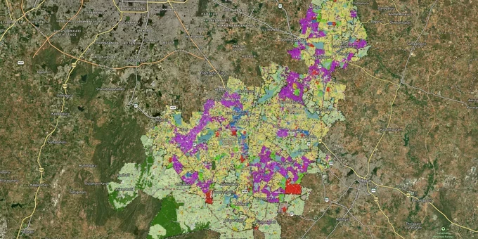
Anekal Masterplan Preview
Try the Anekal Masterplan on the map
Sign in once and explore the layer for a full day.
- No card details needed
- Find nearby verified lands for sale
Overview
The Anekal LPA Master Plan 2031 governs land use across 402.3 sq km south of Bengaluru, under the authority of BMRDA and the Anekal Planning Authority. Approved by the Government of Karnataka vide G.O. No. UDD 151 BMR 2013 dated 03.09.2014, it divides the LPA into Residential, Commercial, Industrial, Public and Semi-Public, Agriculture, and Green Belt zones. Every plot in Anekal has a zone classification. That classification determines what you can build, whether conversion is required, and whether your layout has any legal standing. This page covers the zone rules that matter most to land buyers in the Anekal LPA.
Sarjapura, Attibele, Jigani, and Chandapura: which zone is actually investable
The Anekal LPA Master Plan 2031 identifies four planning districts: Anekal, Sarjapura, Attibele, and Jigani. Each has a different zone character and risk profile. Understanding which district and zone your plot falls in is the single most important pre-purchase step.
The Jigani–Bommasandra–Electronic City–Attibele belt is explicitly identified in the Master Plan as a major economic cluster, anchored by industrial zones around NH-44 (formerly NH-7) from Electronic City to the Tamil Nadu border. This is the corridor where industrial zone land commands a significant premium and where agricultural land adjacent to industrial zones is most frequently misrepresented.
The table below maps the key corridors to their master plan zone character and current growth drivers.
Corridor / Locality
Zone Character (Anekal LPA Master Plan 2031)
Primary Growth Driver
Key Risk
Jigani–Bommasandra
Industrial + Residential
Bommasandra industrial area, proximity to Electronic City
Industrial zone land often sold as residential; check zone map before buying
Attibele Hobli
Residential and some Industrial
NH-44 connectivity, Hosur Road, IT/logistics demand
Unapproved layouts on agricultural fringe land; DC conversion without layout sanction
Sarjapura
Residential (Urban Node)
IT corridor overspill from ORR and Whitefield; STRR alignment
Green belt pockets along nala boundaries restrict construction; confirm zone before purchase
Chandapura–Anekal Road
Residential and agricultural transition
Namma Metro Yellow Line (RV Road–Bommasandra), PRR, proximity to Electronic City
Revenue land and panchayat-approved plots without Anekal Planning Authority sanction
The Namma Metro Yellow Line (RV Road to Bommasandra, 19.15 km, 16 stations) has been fully operational since 11 August 2025; Bommasandra station is approximately 10 minutes from Chandapura. The STRR Dobbaspet-Hoskote section opened in March 2024, improving connectivity between Anekal, Sarjapura, and Attibele. The Peripheral Ring Road (PRR) remains unbuilt — its July 2024 tender was cancelled; a fresh tender for a 19.8 km northern stretch was released in early 2026 but construction has not commenced , land price appreciation along these routes is already priced in at certain nodes, but land further from confirmed station locations still offers entry value.
The most misunderstood corridor is the agricultural fringe around Sarjapura. Green belt and conservation zone designations along the nala and lake buffer areas in Sarjapura Hobli restrict construction entirely. A plot that looks residential on the seller's sketch may sit inside a buffer zone on the actual master plan map. The only way to confirm is to overlay the survey number against the Anekal LPA Master Plan 2031 land use map.
Was this layer helpful?
Anything wrong, outdated, or missing we want to hear it.
For Land Owners & Agents
Looking to sell your land in Karnataka?
I want to sell my land in Bengaluru
10:32
Plz share your Land's location - We will list it on 1acre map, for Free.
10:32

For Land Buyers
Browse all verified lands & plots in Karnataka
Every listing goes through our Preliminary Verification Process.
More Layers in Karnataka
See all 22 layers
Bengaluru BDA Masterplan 2015
View Bengaluru Masterplan as a live map overlay – check any plot's land use zone for free on 1acre.in. Bengaluru BDA mas...

Bengaluru BDA Masterplan Roads: RMP 2015 Road Zones
View Bengaluru Masterplan - Roads alignment as a live map overlay – check road corridor and land impact free on 1acre.in...

BIAAPA Masterplan 2021: North Bengaluru Airport Area Zone Check
View BIAAPA Masterplan as a live map overlay – check any plot's land use zone for free on 1acre.in. BIAAPA Masterplan 20...
More Layers in Karnataka
Bengaluru BDA Masterplan 2015
View Bengaluru Masterplan as a live map overlay – check any plot's land use zone for free on 1acre.in. Bengaluru BDA mas...
Bengaluru BDA Masterplan Roads: RMP 2015 Road Zones
View Bengaluru Masterplan - Roads alignment as a live map overlay – check road corridor and land impact free on 1acre.in...
BIAAPA Masterplan 2021: North Bengaluru Airport Area Zone Check
View BIAAPA Masterplan as a live map overlay – check any plot's land use zone for free on 1acre.in. BIAAPA Masterplan 20...