Bengaluru BDA Masterplan 2015
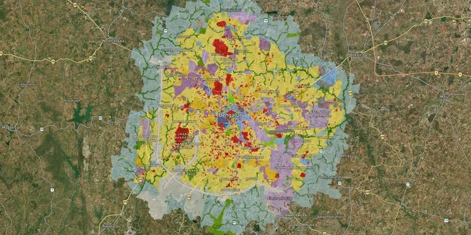
Bengaluru Masterplan Preview
Try the Bengaluru BDA Masterplan 2015 on the map
Sign in once and explore the layer for a full day.
- No card details needed
- Find nearby verified lands for sale
Overview
The Bengaluru BDA masterplan zone classification under the Revised Master Plan 2015 (RMP 2015) is the single most consequential document before any land purchase in the city. Notified by the Government of Karnataka via G.O. No. UDD 540 BEM AA SE 2004 dated 22 June 2007, the RMP 2015 governs the Bangalore Development Authority's Local Planning Area (LPA) covering 1,306 sq km across 387 villages. It remains operative today, as the draft RMP 2031 was withdrawn by BDA in July 2020 after public opposition and has not been resubmitted or notified, and has not been notified. This page covers how zone codes work, where the fraud traps are, which corridors are zoned for growth, and how to use the 1acre Bengaluru Masterplan layer to evaluate any survey number before signing.
Planning-status note (April 2026): in August 2025, BDA floated a global tender for the Revised Master Plan 2041 (RMP-2041), targeting mid-2026 completion; until RMP-2041 is officially notified, all land-use decisions remain governed by RMP 2015. Separately, the Greater Bengaluru Authority (GBA) was established in May 2025 as Bengaluru's apex urban body, and a proposal to transfer planning powers over approximately 800 sq km from BDA to GBA is pending a Karnataka Town and Country Planning Act amendment — until that amendment is notified, BDA remains the statutory planning authority for layout approvals and land-use decisions within its Local Planning Area. The 1,306 sq km LPA figure reflects the original RMP 2015 extent and may change once the transfer is notified.
For plots in the Kempegowda International Airport area north of Bengaluru, see the BIAAPA Masterplan 2021 layer. For BDA's notified road-widening reservations across the city, see the Bengaluru Masterplan Roads layer.
Illegal Layouts and the DC Conversion Trap in Bengaluru's BDA Zone
The most dangerous mistake a land buyer makes in Bengaluru is buying a plotted layout on agricultural land that has never received DC conversion. DC conversion, formally a Conversion Certificate issued by the Deputy Commissioner, is the mandatory first step before any agricultural land can be legally subdivided and sold for residential use under the RMP 2015. Brokers routinely omit this fact, attract buyers with discounted prices, and by the time the Khata is blocked or the building plan is rejected, the promoter has disappeared.
The scale of this problem is documented. BDA has identified 172 unauthorised layouts within its own jurisdiction, spread across approximately 3,109 acres. A 2024 BDA notification flagged 279 illegal layouts concentrated in Yelahanka, Anekal, Bengaluru South, and Bengaluru East taluks, covering over 27,000 individual plots. These layouts were developed without obtaining RMP 2015 land-use conversion approval. In many cases, developers laid concrete roads, drilled borewells, and raised electricity poles to create the appearance of a sanctioned development, while no park or Civic Amenity site was earmarked as required by BDA regulations.
The zone codes below define what is and is not permitted. Each code determines the FAR, permitted uses, and whether a CLU (Change of Land Use) is required before construction.
The table shows the principal RMP 2015 land-use categories applicable within the BDA's Local Planning Area.
Zone Code
Zone Name
Residential Construction Permitted?
DC Conversion Required?
Commonly Misrepresented?
R
Residential (Main / Mixed)
Yes
No (if already converted)
Low
C
Commercial (Central / Business / Mutation Corridor)
Ancillary only
CLU required for residential
Low
I
Industrial (General / Hi-Tech)
No
CLU required
Medium
AG
Agriculture
No
DC Conversion + CLU required
High
OS
Open Space / Parks
No
Prohibited
High
PSP
Public and Semi-Public
No
Authority permission required
Medium
A BDA official confirmed in 2024 that builders selling in flagged layouts had not followed "basic guidelines," with no required road widths, no footpaths, and no parks. Buyers in those layouts will be unable to get a building plan sanction, a Khata transfer, or a bank loan. If a broker cannot show you a valid DC Conversion Order and confirm the survey number is outside the BDA's illegal layout list, the transaction ends there.
Growth Corridors Where the BDA Masterplan Zone Directly Affects Land Value
Bengaluru's land market moves corridor by corridor, and the BDA zone classification under RMP 2015 is the underlying driver of which corridors have investable land and which are still locked in agricultural or open-space designations.
The strongest current corridors are differentiated by both zone status and infrastructure triggers. North Bengaluru, particularly Yelahanka, Hebbal, Thanisandra, and Devanahalli, is zoned for a mix of residential, commercial, and Hi-Tech industrial land uses in the RMP 2015. The Devanahalli belt, anchored by Kempegowda International Airport and the proposed Namma Metro Blue Line expansion, has seen consistent price appreciation. East Bengaluru, covering Whitefield, Sarjapur Road, Varthur, and Panathur Road, sits on largely residential and some commercial zones under the RMP 2015 and benefits from direct access to the ITPL, Outer Ring Road IT corridor, and Metro Purple Line. South Bengaluru corridors including Kanakapura Road have gained materially from the Namma Metro Green Line extension. The Peripheral Ring Road (PRR), for which BDA was acquiring approximately 750 acres as of late 2024, will when complete restructure land values across East and South-East Bengaluru.
The table below maps each corridor to its dominant zone type and primary risk factor.
Corridor
Dominant RMP 2015 Zone
Infrastructure Drivers
Key Risk
Sarjapur Road
Residential (R), some Commercial
ORR IT corridor; proposed Metro Yellow Line extension (Bommasandra–Sarjapur–Hoskote)
Rapid layout formation, verify DC conversion
Devanahalli / Yelahanka
Residential + Hi-Tech Industrial
Airport, Metro Blue Line expansion
Some AG-zoned pockets sold as residential
Whitefield / Panathur
Residential + Commercial
ITPL, Metro Purple Line
Peripheral survey numbers may still be AG zone
Kanakapura Road
Residential + Open Space
Metro Green Line extension
OS and valley-zone plots still being sold
Hesaraghatta / North fringe
Agricultural (AG) dominant
Long-term speculation
No CLU, no conversion; high fraud exposure
The corridor most misread by buyers is the Hesaraghatta and outer North Bengaluru fringe. Proximity to Yelahanka and BDA's proposed Shivaram Karanth Layout has created speculative pricing on land that remains classified AG under the RMP 2015, with no conversion in place. Buying AG-zoned land at residential prices without a CLU approval is a documented path to loss.
Planning-status note (April 2026): Namma Metro Phase 3 (Aug 2024 Union Cabinet approval, construction expected to begin late 2025) serves JP Nagar–Kempapura and Hosahalli–Kadabagere corridors. The Hebbal–Sarjapur line is proposed Metro Yellow Line extension — still at proposal stage with an estimated completion around 2033. "Infrastructure Drivers" in this table reflect announced or under-construction projects, not speculative investment upside.
Was this layer helpful?
Anything wrong, outdated, or missing we want to hear it.
For Land Owners & Agents
Looking to sell your land in Karnataka?
I want to sell my land in Bengaluru
10:32
Plz share your Land's location - We will list it on 1acre map, for Free.
10:32

For Land Buyers
Browse all verified lands & plots in Karnataka
Every listing goes through our Preliminary Verification Process.
More Layers in Karnataka
See all 22 layers
Bengaluru BDA Masterplan Roads: RMP 2015 Road Zones
View Bengaluru Masterplan - Roads alignment as a live map overlay – check road corridor and land impact free on 1acre.in...

Bengaluru STRR (Satellite Town Ring Road): Route Map and Land Impact
View STRR alignment as a live map overlay – check road corridor and land impact free on 1acre.in. Bengaluru STRR land bu...
Bengaluru - Vijayawada Expressway
View Bengaluru - Vijayawada Expressway alignment as a live map overlay – check land acquisition risk and plot proximity ...
More Layers in Karnataka
Bengaluru BDA Masterplan Roads: RMP 2015 Road Zones
View Bengaluru Masterplan - Roads alignment as a live map overlay – check road corridor and land impact free on 1acre.in...
Bengaluru STRR (Satellite Town Ring Road): Route Map and Land Impact
View STRR alignment as a live map overlay – check road corridor and land impact free on 1acre.in. Bengaluru STRR land bu...
Bengaluru - Vijayawada Expressway
View Bengaluru - Vijayawada Expressway alignment as a live map overlay – check land acquisition risk and plot proximity ...