Nelamangala Masterplan 2031: BMRDA Zone Check and Land Use Guide
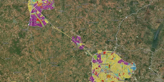
Nelamangala Masterplan Preview
Try the Nelamangala Masterplan 2031 on the map
Sign in once and explore the layer for a full day.
- No card details needed
- Find nearby verified lands for sale
Overview
The Nelamangala LPA masterplan zone governs all land use in one of Bengaluru's fastest-growing western corridors. The Nelamangala LPA Masterplan 2031, provisionally approved by the Bangalore Metropolitan Region Development Authority under G.O. No. UDD 150 BMR 2013, divides the local planning area into nine use zones, each with distinct permitted uses, FAR limits, and conversion requirements under the Karnataka Town and Country Planning Act, 1961. This page covers the zone classification system, the regulatory traps that catch buyers in this corridor, and the micro-markets where the plan creates or destroys land value.
Agricultural zone and phase-II land: the trap that resets a Nelamangala deal to zero
The single most expensive mistake buyers make in the Nelamangala LPA is treating every yellow-colored parcel on a broker's map as immediately buildable. The masterplan is unambiguous: no change of land use is permissible in the Agricultural Zone under Section 14-A of the KTCP Act, 1961, and no approvals for development or no-objection certificates for conversion to non-agricultural use are permissible in Phase II urbanizable areas, which cover land planned for development only between 2021 and 2031. A broker showing you a site inside Phase II as "ready for layout" is showing you something that does not legally exist yet.
This is not a theoretical risk. In August 2025, the Karnataka Revenue Department identified approximately 30,340 suspected illegal layout cases statewide. Investigations confirmed that officials collaborated with landowners to bypass conversion requirements by using 11E maps issued without actual conversion, later patched through land record corrections called "phodi durasthi." Several officials have been suspended. Separately, a Karnataka housing cooperative was implicated in a Rs 316-crore scam with announced layouts in Nelamangala, Varthur, and Devanahalli. And in W.P. No. 21648 of 2024, the Karnataka High Court found that converted land not forming part of an approved layout cannot receive an e-Khata, even if the owner holds a conversion order and has paid property tax for years.
The table below summarises the Nelamangala LPA Masterplan 2031 zone codes and what a buyer can and cannot do in each.
Zone
Permitted as-of-right
Requires DC conversion?
Key restriction
Residential
Plots, villas, apartments, group housing (min. 1 ha)
Yes, from agriculture
Hospitals need min. 750 sq m and 12 m road
Commercial
All residential uses plus offices, retail, warehouses, multiplexes
Yes, from agriculture
Mezzanine permitted on commercial only
Industrial
All industries including IT/BT; 40% residential quarters allowed for 10+ ha sites
Yes, from agriculture
KSPCB clearance required for obnoxious industries
Agricultural (Phase I)
Farmhouses up to 200 sq m plinth within 1.2 ha minimum plot
Not required for agricultural use
No layout or CLU in this zone
Agricultural (Phase II)
Agriculture only
No NOC for any non-agricultural development permitted
Do not purchase for residential/industrial development
Parks and Open Spaces
Parks, playgrounds; ancillary uses max 5% of area, G+1 only
N/A
30 m no-development buffer around lakes of 10 ha and above; 9 m around Raj Kaluves
DC conversion for non-agricultural use is mandatory under Section 95 of the Karnataka Land Revenue Act. Under the 2025 amendments to that Act, misuse of conversion orders now attracts cancellation, land confiscation, and fines of up to Rs 1 lakh plus Rs 2,500 per day , recorded as an encumbrance on the RTC extract. If a seller cannot show you a dated conversion order cross-referenced against the actual survey number on the masterplan map, the transaction is not ready to proceed.
Where the Nelamangala LPA masterplan creates investable land: NH-48, Arasinakunte, and the STRR node
The masterplan shapes value very differently across the LPA. Three corridors account for most of the legitimate buyer activity in Nelamangala today.
The NH-48 (Tumkur Road) corridor running through Arasinakunte and Adarsh Nagar carries the highest concentration of BMRDA and NPA-approved residential layout activity. Most developer projects here are in the Residential Zone, priced between Rs 3,649 and Rs 6,099 per sq ft as of late 2025. The FAR for residential use on roads over 9 m and up to 12 m wide is 1.75, rising to 2.0 on roads over 12 m. Group housing on plots above 1 ha requires a minimum 12 m approach road, 15% civic amenity reservation, and FAR calculated only on net area after deducting that reservation.
The Industrial Zone along NH-48 near Dobbaspet attracts logistics, warehousing, and manufacturing buyers. Industrial plots here were listed at Rs 2.5 crore per 10,000 sq ft unit as of 2024. The plan permits IT/BT industries on plots above 5 ha in the Industrial Zone to allocate 30% of area to residential apartments for employees, subject to KSPCB clearance. The Chennai-Bangalore-Chitradurga Industrial Corridor, where it falls within the LPA, is explicitly recognised in the masterplan as a permitted development.
The third corridor is the STRR alignment. The 288-km Bengaluru Satellite Town Ring Road (NH-948A) lists Nelamangala as a node. The 80-km Dobbaspet-Hoskote section was inaugurated by PM Modi on 11 March 2024, with tolling operational from June 2024. Land along the Dobbaspet-Nelamangala-Bidadi stretch , the longest STRR section at 43 km , is attracting logistics and land banking interest. Land prices in Nelamangala are reported to be growing at 22% year-on-year, with entry-level site pricing around Rs 5,500 per sq ft, the lowest among the STRR nodes. A proposed airport on the Nelamangala-Kunigal Road, if confirmed, could produce a sharp step-change in values, but as of March 2026 no official notification has been issued.
Corridor
Zone classification
Current price range
Infrastructure & economic drivers
Key risk
Arasinakunte / Adarsh Nagar (NH-48)
Residential
Rs 3,600–6,100/sq ft
BMRDA-approved plotted development
Unsanctioned layouts adjacent to approved ones
Dobbaspet industrial belt
Industrial
Rs 2–2.5 Cr per 10,000 sq ft
Logistics, warehousing, STRR node
KSPCB clearances; agricultural zone parcels intermixed
NH-48/STRR junction
Mixed (residential and agricultural phase I transition)
Rs 5,500/sq ft average
STRR connectivity, proposed airport
Phase II land sold as buildable; visit site in monsoon to check drainage
The Nelamangala-Sondekoppa Road corridor is emerging, with layouts citing its expressway-like upgrade, but civic infrastructure on feeder roads varies sharply by exact location. Do not evaluate a Nelamangala site from satellite imagery alone: roads that look developed in summer can reveal flooding and drainage failures in the monsoon.
Was this layer helpful?
Anything wrong, outdated, or missing we want to hear it.
For Land Owners & Agents
Looking to sell your land in Karnataka?
I want to sell my land in Bengaluru
10:32
Plz share your Land's location - We will list it on 1acre map, for Free.
10:32

For Land Buyers
Browse all verified lands & plots in Karnataka
Every listing goes through our Preliminary Verification Process.
More Layers in Karnataka
See all 22 layers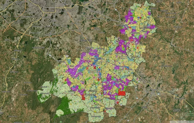
Anekal Masterplan: Zone Check and Land Use Guide
View Anekal Masterplan as a live map overlay – check any plot's land use zone for free on 1acre.in. Anekal masterplan zo...
Bengaluru BDA Masterplan 2015
View Bengaluru Masterplan as a live map overlay – check any plot's land use zone for free on 1acre.in. Bengaluru BDA mas...

Bengaluru BDA Masterplan Roads: RMP 2015 Road Zones
View Bengaluru Masterplan - Roads alignment as a live map overlay – check road corridor and land impact free on 1acre.in...
More Layers in Karnataka
Anekal Masterplan: Zone Check and Land Use Guide
View Anekal Masterplan as a live map overlay – check any plot's land use zone for free on 1acre.in. Anekal masterplan zo...
Bengaluru BDA Masterplan 2015
View Bengaluru Masterplan as a live map overlay – check any plot's land use zone for free on 1acre.in. Bengaluru BDA mas...
Bengaluru BDA Masterplan Roads: RMP 2015 Road Zones
View Bengaluru Masterplan - Roads alignment as a live map overlay – check road corridor and land impact free on 1acre.in...