Hoskote Masterplan 2031: BMRDA Zone Check and Land Use Guide
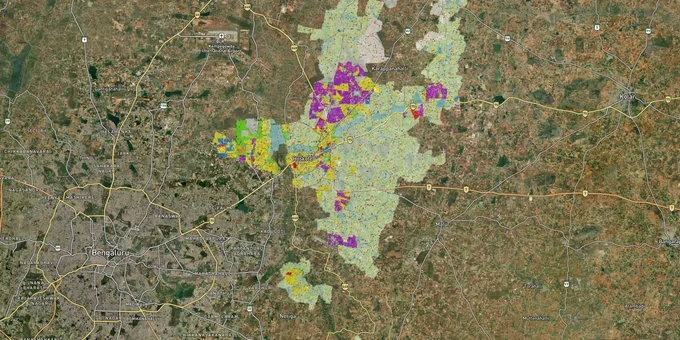
Hoskote Masterplan Preview
Try the Hoskote Masterplan 2031 on the map
Sign in once and explore the layer for a full day.
- No card details needed
- Find nearby verified lands for sale
Overview
The Hoskote masterplan zone classification under the Hoskote LPA Masterplan 2031, prepared by BMRDA, is the governing land-use document for 591.72 sq km covering 316 villages east of Bengaluru. Administered by the Hoskote Town Planning Authority under the Karnataka Town and Country Planning Act, 1961, the plan divides the LPA into residential, commercial, industrial, public and semi-public, and parks and open spaces zones. The 2011 population of 2,81,993 is projected to reach 5,00,000 by 2031. This page covers zone fraud risks unique to the Hoskote LPA, which corridors carry the strongest investment thesis, and how to use the 1acre Hoskote Masterplan layer before signing.
Where the Hoskote LPA Masterplan 2031 Zone Directly Shapes Investment Value
Two distinct investment theses operate inside the Hoskote LPA, and the masterplan zone is what separates them. Industrial-zone corridors near the KIADB clusters are not residential plays; residential-zone corridors along Old Madras Road and Budigere Cross are not industrial plays. Buying in the wrong zone for your intended use requires a Change of Land Use (CLU) approval routed through the Chief Minister's Office via BMRDA, a process that takes six to nine months and has no guaranteed outcome.
The sharpest land value driver in the LPA is the Bengaluru-Chennai Expressway (NE-7), which originates at Hoskote and runs 260 km to Sriperumbudur. Land along the expressway corridor and around the KIADB industrial area near Narsapura, home to Volvo, Honda, and Bando across more than 3,000 acres, has drawn consistent industrial and logistics demand. The Satellite Town Ring Road (STRR) adds a second catalyst: the 80 km Dobaspete-Hoskote section was inaugurated by PM Modi on 11 March 2024, making Hoskote the eastern anchor of an operational access-controlled expressway. The Budigere Cross node on Old Madras Road (NH-75) functions as a residential transition zone between Whitefield's IT corridor and the Hoskote LPA boundary, and is zoned predominantly residential in the masterplan.
The table below maps the active corridors in the Hoskote LPA to their dominant zone and known risk.
Corridor
Dominant LPA 2031 Zone
Infrastructure & Economic Drivers
Key Risk
Narsapura / KIADB belt
Industrial (I)
Volvo, Honda, KIADB 3,000+ acre cluster
Marketed residentially; CLU required for housing
Old Madras Road (NH-75) frontage
Commercial / Residential
Expressway access, logistics
Unconverted agricultural pockets behind frontage plots
Budigere Cross
Residential (R)
Whitefield proximity, STRR junction
Panchayat-approved layouts on AG-zone land
Hoskote town core
Residential + Commercial
LPA planning district, established civic amenities
Limited new land supply; check plan district map
Tavarekere belt
Emerging / Mixed
Proposed 300-acre Data Centre Park
No confirmed zone reclassification yet
The corridor most misread by buyers is the Narsapura-KIADB belt. Industrial zones under the Hoskote LPA 2031 do not permit residential construction. Plots marketed as "adjacent to Honda and Scania" at residential prices often sit inside Industrial (I) zones or on unconverted agricultural land abutting the KIADB boundary. Confirm the zone classification on the masterplan layer before interpreting the broker's infrastructure narrative.
Was this layer helpful?
Anything wrong, outdated, or missing we want to hear it.
For Land Owners & Agents
Looking to sell your land in Karnataka?
I want to sell my land in Bengaluru
10:32
Plz share your Land's location - We will list it on 1acre map, for Free.
10:32

For Land Buyers
Browse all verified lands & plots in Karnataka
Every listing goes through our Preliminary Verification Process.
More Layers in Karnataka
See all 22 layers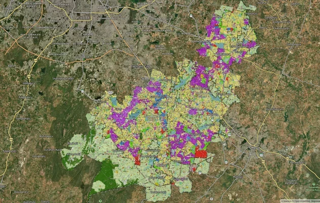
Anekal Masterplan: Zone Check and Land Use Guide
View Anekal Masterplan as a live map overlay – check any plot's land use zone for free on 1acre.in. Anekal masterplan zo...
Bengaluru BDA Masterplan 2015
View Bengaluru Masterplan as a live map overlay – check any plot's land use zone for free on 1acre.in. Bengaluru BDA mas...

Bengaluru BDA Masterplan Roads: RMP 2015 Road Zones
View Bengaluru Masterplan - Roads alignment as a live map overlay – check road corridor and land impact free on 1acre.in...
More Layers in Karnataka
Anekal Masterplan: Zone Check and Land Use Guide
View Anekal Masterplan as a live map overlay – check any plot's land use zone for free on 1acre.in. Anekal masterplan zo...
Bengaluru BDA Masterplan 2015
View Bengaluru Masterplan as a live map overlay – check any plot's land use zone for free on 1acre.in. Bengaluru BDA mas...
Bengaluru BDA Masterplan Roads: RMP 2015 Road Zones
View Bengaluru Masterplan - Roads alignment as a live map overlay – check road corridor and land impact free on 1acre.in...