Bengaluru BDA Masterplan Roads: RMP 2015 Road Zones
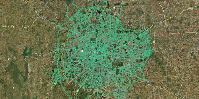
Bengaluru Masterplan Roads Preview
Try the Bengaluru BDA Masterplan Roads on the map
Sign in once and explore the layer for a full day.
- No card details needed
- Find nearby verified lands for sale
Overview
The Bengaluru BDA Master Plan 2015 Roads layer, prepared by the Bangalore Development Authority under G.O. No. UDD 540 BEM AA SE 2004 and covering the entire BDA Local Planning Area, maps every road the authority proposed to form or widen within the city. A plot sitting inside a BDA RMP 2015 road widening zone cannot be built upon as if it were free land. Road zones are reservations under Section 12(1)(c) of the KTCP Act 1961 (the Karnataka High Court ruled in January 2024 that such reservations lapse if not acquired within 5 years), meaning the reservation does not expire until the road is executed or the plan is revised.
Road Zone Markings in BDA RMP 2015: The Acquisition Risk Most Bengaluru Buyers Miss
Many buyers in Bengaluru discover a road zone problem only after they have paid the registration fees. The BDA's own advisory committee noted in its report on RMP 2015 that proposed roads were not adequately demarcated on the ground, meaning landowners often have no physical warning that their plot is partially reserved. A case in Ganigarahalli, North Bengaluru, became public when BDA issued acquisition notices for a 30-metre road listed in RMP 2015, threatening pillars of an existing apartment building. BDA officials acknowledged at the time that the authority did not maintain a comprehensive record of all road widenings notified under the plan. BDA's RMP 2031 has been in revision since 2017; verify whether revised alignments differ from RMP 2015 before transacting.
Road Zone Classifications Under BDA RMP 2015
The table below shows the road classifications and their consequences for plots that abut or overlap them under BDA RMP 2015 road zone land rules.
Road Category in RMP 2015
Proposed Width
Effect on Abutting Plot
TDR Available?
New arterial / ring road
30 m and above
Frontage acquired; FAR calculated on remaining plot after surrender
Yes, 2x area of surrendered land as DRC
Road widening of existing road
18 m to 24 m (60–80 ft)
Setback re-measured from post-widening edge; loss of frontage
Yes, subject to 15-day TDR application window from notice
Minor road widening
Up to 18 m
Possible partial frontage loss; higher FAR unlocked if road is 12 m or above
Yes
Peripheral Ring Road (PRR / BBC) corridor
100 m greenfield
Full acquisition of affected extent; no building permission in notified zone
Yes (five compensation options offered by BDA)
The one fact you will not find on the BDA website: for smaller plots under one acre, road widening can raise permissible FAR in theory while making it physically impossible to achieve the higher FAR given the reduced site dimension. A plot that loses frontage to a 24-metre widening and falls below minimum plot size for its zone cannot benefit from the premium FAR uplift at all. Cross-check the survey number on the 1acre BDA Road layer against the Zoning Regulations Volume III to know whether the remaining area after surrender crosses the minimum threshold for your intended use.
Road Corridors Where RMP 2015 Notifications Most Affect Buyers
The RMP 2015 road network divides Bengaluru's growth corridors into two types: those where road-widening risk has already been absorbed by the market and those where buyers are still paying full price for land that carries an unpriced acquisition risk.
The table below maps the Peripheral Ring Road land value corridors and other key Bengaluru road-affected belts to their current risk profile using sourced data.
Corridor / Locality
Road Affect from RMP 2015
Infrastructure Drivers
Risk Level
Varthur–Gunjur belt (East)
PRR / BBC Phase 1 notified; land prices ₹15–40 cr/acre claimed by landowners under LARR 2013, disputed against BDA negotiated framework
IT Corridor, Sarjapur Road proximity
High: acquisition price dispute ongoing as of 2026
Devanahalli / North Bengaluru
NH-44 corridor widening, PRR Phase 1 terminus
Airport, KIADB Aerospace Park
Moderate: road corridor well-established; watch for PRR Phase 2 DPR
Sarjapur Road (BMRDA belt)
Outer Ring Road junction, KIADB SWIFT City industrial hub (~1,000 acres — Karnataka Industrial Areas Development Board project for startups, not a BDA residential layout)
IT hub, metro extension
Moderate: growth confirmed; check individual survey against road layer
ITPL Main Road (Whitefield)
BBMP road widening to wider carriage per RMP; acquisition resistance ongoing
Tech hub
Moderate: BBMP widening active as of 2025; frontage plots most affected
Kachamaranahalli / PRR Phase 1 villages
1,810 acres notified June 2007; additional 750 acres preliminary-notified April 2020
PRR / BBC corridor
Very High: sale and mortgage blocked until acquisition resolved
The most misunderstood corridor is the Peripheral Ring Road belt. Land prices along PRR Phase 1 villages have risen sharply, with some pockets trading at ₹15 crore to ₹40 crore per acre. Yet the BDA's notified acquisition at far lower guidance values, revised downward by corrigendum in March 2024, means these plots remain effectively unmarketable for construction without a resolution. Buying land in a PRR-notified survey number on the assumption that the project will lapse is a documented pattern in Bengaluru real estate; it is also how buyers end up unable to sell, mortgage, or build for years.
Was this layer helpful?
Anything wrong, outdated, or missing we want to hear it.
For Land Owners & Agents
Looking to sell your land in Karnataka?
I want to sell my land in Bengaluru
10:32
Plz share your Land's location - We will list it on 1acre map, for Free.
10:32

For Land Buyers
Browse all verified lands & plots in Karnataka
Every listing goes through our Preliminary Verification Process.
More Layers in Karnataka
See all 22 layers
Anekal Masterplan: Zone Check and Land Use Guide
View Anekal Masterplan as a live map overlay – check any plot's land use zone for free on 1acre.in. Anekal masterplan zo...
Bengaluru BDA Masterplan 2015
View Bengaluru Masterplan as a live map overlay – check any plot's land use zone for free on 1acre.in. Bengaluru BDA mas...

BIAAPA Masterplan 2021: North Bengaluru Airport Area Zone Check
View BIAAPA Masterplan as a live map overlay – check any plot's land use zone for free on 1acre.in. BIAAPA Masterplan 20...
More Layers in Karnataka
Anekal Masterplan: Zone Check and Land Use Guide
View Anekal Masterplan as a live map overlay – check any plot's land use zone for free on 1acre.in. Anekal masterplan zo...
Bengaluru BDA Masterplan 2015
View Bengaluru Masterplan as a live map overlay – check any plot's land use zone for free on 1acre.in. Bengaluru BDA mas...
BIAAPA Masterplan 2021: North Bengaluru Airport Area Zone Check
View BIAAPA Masterplan as a live map overlay – check any plot's land use zone for free on 1acre.in. BIAAPA Masterplan 20...