Karnataka CRZ
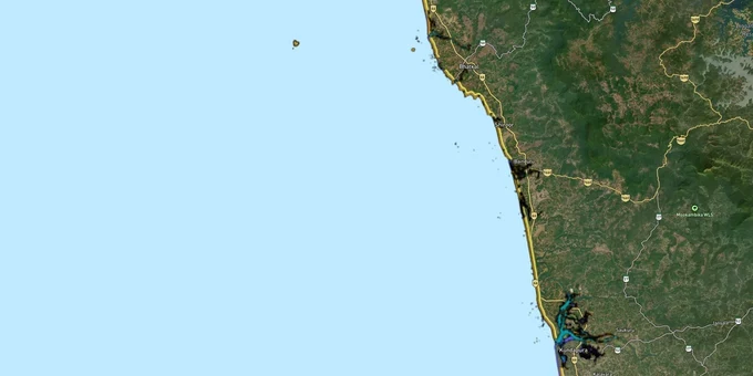
Karnataka Crz Preview
Try the Karnataka CRZ on the map
Sign in once and explore the layer for a full day.
- No card details needed
- Find nearby verified lands for sale
Overview
The Karnataka CRZ layer plots the Coastal Regulation Zone footprint along the state's 320 km coastline on the Arabian Sea. It mirrors the Coastal Zone Management Plan approved by MoEFCC at the National Coastal Zone Management Authority's 45th meeting on 1 September 2022, prepared under CRZ Notification 2019 (G.S.R. 37(E)) for three coastal districts: Uttara Kannada, Udupi, and Dakshina Kannada. The Karnataka State Coastal Zone Management Authority (KSCZMA) is the regulatory body. Karnataka is one of only four approved states under CRZ 2019, alongside Odisha, Maharashtra, and Kerala (Kerala's 10 districts approved October 2024). This page shows what falls inside CRZ-I, II, III A, III B, and IV across the Karnataka coast.
Regulatory Red Flags Around Karwar, Coondapur and the Sewage-Polluted Stretch
Karnataka has two of India's listed Critical Vulnerable Coastal Areas: Karwar and Coondapur CVCA (Critical Vulnerable Coastal Area), both named explicitly in CRZ Notification 2019 alongside Sundarban, Vembanad, and Gulf of Mannar. The CAG (Comptroller and Auditor General) performance audit also documented untreated sewage discharge from 11 of 12 coastal urban local bodies in Karnataka directly into the sea. Only Mangalore City Corporation operates a 100% sewage network with four treatment plants.
The fact-pack on what each zone permits in Karnataka, drawn from CRZ Notification 2019 and the approved Karnataka CZMP.
Zone Code
Permitted Use
Requires CRZ Clearance?
Prohibited Without?
Commonly Misrepresented?
CRZ-I A
Karwar CVCA, Coondapur CVCA, mangroves, sand dunes, turtle nesting
No new construction; only utility
Any building
Sold as "beach plots"
CRZ-I B
Inter-tidal between LTL (Low Tide Line) and High Tide Line
Salt works, pipelines only
Houses, resorts
Marketed as "beachfront villas"
CRZ-II
Built-up Mangalore, Udupi, Karwar municipal areas
Yes, on landward side of existing road
Construction on seaward side
Confused with CRZ-III rural
CRZ-III A
Densely populated rural; NDZ (No Development Zone) 50 m from HTL
Beyond NDZ only
Construction inside 50 m
Quoted as "panchayat approved"
CRZ-III B
Sparse rural; NDZ 200 m from HTL
Beyond NDZ only
Anything inside 200 m
Sold without 2011 census check
CRZ-IV A/B
Sea up to 12 nautical miles + tidal water bodies (Netravathi, Sharavathi, Kali)
Fishing only
Reclamation, dwellings
Sold as "river-facing"
The Karnataka-specific trap is the assumption that local panchayat or town panchayat approvals override CRZ. The CAG audit flagged two specific Karnataka violations: four additional berths at New Mangalore Port and a petroleum product storage terminal at Karwar. If a parcel sits along the Tulu-Konkan stretch in Ullal, Mulki, Saligrama, Honnavar, Kumta, or Ankola, where eight cities still depend on septic tanks and soak-pits, expect tighter enforcement once sewage compliance is forced through KSCZMA review.
Growth Corridors From Mangalore to Karwar Across the Tulu-Konkan Belt
Karnataka's coast splits into three personalities. The Mangalore Udupi Karwar coast stretches across Dakshina Kannada urban (CRZ-II dominated), Udupi semi-urban with mixed CRZ-II and CRZ-III, and Uttara Kannada largely rural (CRZ-III A and III B). The Karnataka Tourism Policy 2020-26 has identified all three coastal districts as Focus Tourism Destinations, with KSCZMA clearance mandatory for any hotel, resort, jetty, or shack on the 92 beaches mapped in the CZMP Tourism Plan. The Karnataka Tourism Policy 2020-26 expires in 2026 — verify whether a successor policy has been notified before relying on tourism-permit assumptions.
The corridors most asked about, mapped against CRZ classification under the approved Karnataka CZMP.
Corridor / Locality
Zone (Karnataka CZMP 2019)
Growth Driver
Known Risk
Mangalore city, Panambur to Tannirbhavi
CRZ-II + CRZ-IV (Netravathi-Gurupura)
Port, IT, education hub
Construction only landward of existing roads
New Mangalore Port + Panambur
CRZ-II + Notified Port limits
Major port, additional berths
CAG flagged berth construction violations
Ullal, Someshwara, Talapady
CRZ-III A and III B
Coastal Highway, NRI demand
NDZ enforced; seawall and erosion zones
Udupi-Malpe-Kaup
CRZ-II + CRZ-III mix
St Mary's Island tourism, port
25% sewerage coverage; CRZ-III B densities
Coondapur, Kundapura, Maravanthe
CRZ-I A (CVCA) + CRZ-III B
Kollur tourism, beach belt
Coondapur CVCA blanket restriction
Honnavar, Kumta, Gokarna
CRZ-III A and III B
Spiritual tourism, beaches
Septic-tank dependent; ESA mapping pending
Karwar, Devbagh, Tilmati
CRZ-I A (CVCA) + CRZ-II
Naval base, port, beach tourism
Karwar CVCA + petroleum terminal violations. NGT Southern Bench has ordered status quo on Karwar commercial port expansion — buyers near Baitkhol should verify current order status before any transaction.
The most misunderstood corridor is the Gokarna-Kumta-Honnavar belt. Buyers see beach-resort listings and assume CRZ-III B at 200 m NDZ is the only constraint. Eight municipalities along this stretch (Ullal, Mulki, Kundapura, Saligrama, Honnavar, Kumta, Ankola plus partial Bhatkal) have no sewerage network. Resort approvals in this belt now require sewage treatment as a condition of KSCZMA recommendation, regardless of zone classification.
Was this layer helpful?
Anything wrong, outdated, or missing we want to hear it.
For Land Owners & Agents
Looking to sell your land in Karnataka?
I want to sell my land in Bengaluru
10:32
Plz share your Land's location - We will list it on 1acre map, for Free.
10:32

For Land Buyers
Browse all verified lands & plots in Karnataka
Every listing goes through our Preliminary Verification Process.
More Layers in Karnataka
See all 22 layers
Karnataka Survey Number Map — Find Any Plot's Survey Number Free | 1acre.in
See any plot's survey number in Karnataka on a free live map. RTC (Pahani), Bhoomi and the Dishaank GPS app explained, p...
Anekal Masterplan: Zone Check and Land Use Guide
View Anekal Masterplan as a live map overlay – check any plot's land use zone for free on 1acre.in. Anekal masterplan zo...
Bengaluru BDA Masterplan 2015
View Bengaluru Masterplan as a live map overlay – check any plot's land use zone for free on 1acre.in. Bengaluru BDA mas...
More Layers in Karnataka
Karnataka Survey Number Map — Find Any Plot's Survey Number Free | 1acre.in
See any plot's survey number in Karnataka on a free live map. RTC (Pahani), Bhoomi and the Dishaank GPS app explained, p...
Anekal Masterplan: Zone Check and Land Use Guide
View Anekal Masterplan as a live map overlay – check any plot's land use zone for free on 1acre.in. Anekal masterplan zo...
Bengaluru BDA Masterplan 2015
View Bengaluru Masterplan as a live map overlay – check any plot's land use zone for free on 1acre.in. Bengaluru BDA mas...