BIAAPA Masterplan 2021: North Bengaluru Airport Area Zone Check
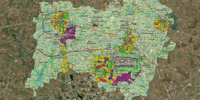
Biaapa Masterplan Preview
Try the BIAAPA Masterplan 2021 on the map
Sign in once and explore the layer for a full day.
- No card details needed
- Find nearby verified lands for sale
Overview
The BIAAPA Masterplan 2021 governs land use across 228 villages surrounding Kempegowda International Airport, administered by the Bengaluru International Airport Area Planning Authority (BIAAPA) under the Karnataka Town and Country Planning Act, 1961. The plan divides its local planning area into residential, commercial, industrial, public utility, and green zones, each with specific FAR limits, setback requirements, and permitted uses. Checking a plot's classification under the BIAAPA Masterplan 2021 before purchase is the first and most consequential step any buyer in this region must take.
CLU and the agricultural land trap that catches buyers across Devanahalli and Doddaballapur
Most land within BIAAPA's jurisdiction starts as agricultural. That classification does not change because a developer has cut a parcel into plots and advertised it as BIAAPA approved. If the BIAAPA Master Plan 2021 shows a survey number within a residential zone, the owner still needs a formal Change of Land Use (CLU) order from BIAAPA under the Karnataka Town and Country Planning Act, 1961, before any construction can legally proceed.
Note: a 2017–18 delimitation moved roughly 257 villages of Doddaballapur taluk into the separate Doddaballapura Planning Authority (dbpurapa.in); verify which authority governs your specific parcel before relying on BIAAPA data alone.
CLU Process and Airport-Zone Restrictions Under BIAAPA
The CLU process is where buyers in the airport zone most commonly get hurt. The table below shows exactly what it involves:
Step
What Happens
Responsible Party
Application
Land ownership proof, road details, affidavits submitted
Buyer / Developer
Public notice
Newspaper notification open for objections, minimum 15 days
BIAAPA
State referral
BIAAPA sends recommendations to the state government via BMRDA
BIAAPA
Decision
The state government approves or rejects; both parties must comply
State Government
Timeline
Up to 60 days from complete submission
-
Beyond CLU, the BIAAPA zone map also governs airport height restrictions. Color-coded zones around the runway impose strict building height limits; parcels farther from the airport have more relaxed norms. Neither fact appears on any broker brochure. A layout being BIAAPA approved and a developer holding the release order to sell individual plots are two separate clearances: always ask for the release order specifically.
Devanahalli, Yelahanka, and the Doddaballapur Road corridor: how the BIAAPA Masterplan 2021 shapes investment risk
Not every parcel within BIAAPA's 228-village jurisdiction carries the same development potential. Plots zoned green or public utility under the BIAAPA Masterplan 2021 cannot be converted to residential use, regardless of their proximity to the Aerospace SEZ, STRR junctions, or Metro Phase 2B stations. The zone classification in the master plan is the single variable that separates a bankable asset from agricultural land that will remain agricultural.
The table below maps the key micro-markets within BIAAPA jurisdiction and what each zone classification means for construction rights and risk:
Corridor
Dominant Zone Type
Infrastructure Drivers
Primary Risk
Devanahalli (NH-44 belt, Gokare)
Residential / Commercial
KIADB Aerospace Park (Bagalur), BIAL expansion, Metro Phase 2B
Airport NOC required for height; release order is often missing
Doddaballapur Road (Rajanakunte, Bagalur)
Residential / Industrial Mix
STRR interchange, KIADB industrial allotments
Agricultural land misrepresented as residential zone; many parcels along this corridor now fall under the Doddaballapura Planning Authority (dbpurapa.in), not BIAAPA — verify authority before relying on this map
Yelahanka-Chikkajala belt
Residential / Green (mixed)
KHB 43-acre township (cabinet-approved, pre-construction), Yelahanka flyover
Green-zoned parcels ineligible for CLU; sold freely by brokers
The Yelahanka–Chikkajala belt is where the most misrepresentation occurs. BIAAPA's strict zoning regulations intentionally limit high-density development in specific green zones here; the master plan shows many parcels in public utility or green use, not residential. No CLU application on a green-zoned parcel will succeed. Check the zone on the BIAAPA Masterplan 2021 map before any other step in your diligence.
Planning-status note (April 2026): the Namma Metro Phase 2B airport line is now expected around 2027; the Aerocity Phase II extension was cancelled by the Karnataka cabinet in July 2025 after farmer protests, though the existing KIADB Aerospace Park at Bagalur remains operational; and the KHB 43-acre Yelahanka township is cabinet-approved but pre-construction as of September 2025.
Was this layer helpful?
Anything wrong, outdated, or missing we want to hear it.
For Land Owners & Agents
Looking to sell your land in Karnataka?
I want to sell my land in Bengaluru
10:32
Plz share your Land's location - We will list it on 1acre map, for Free.
10:32

For Land Buyers
Browse all verified lands & plots in Karnataka
Every listing goes through our Preliminary Verification Process.
More Layers in Karnataka
See all 22 layers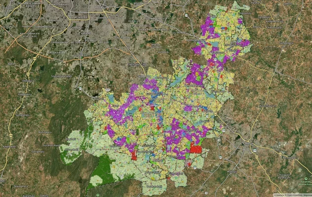
Anekal Masterplan: Zone Check and Land Use Guide
View Anekal Masterplan as a live map overlay – check any plot's land use zone for free on 1acre.in. Anekal masterplan zo...
Bengaluru BDA Masterplan 2015
View Bengaluru Masterplan as a live map overlay – check any plot's land use zone for free on 1acre.in. Bengaluru BDA mas...

Bengaluru BDA Masterplan Roads: RMP 2015 Road Zones
View Bengaluru Masterplan - Roads alignment as a live map overlay – check road corridor and land impact free on 1acre.in...
More Layers in Karnataka
Anekal Masterplan: Zone Check and Land Use Guide
View Anekal Masterplan as a live map overlay – check any plot's land use zone for free on 1acre.in. Anekal masterplan zo...
Bengaluru BDA Masterplan 2015
View Bengaluru Masterplan as a live map overlay – check any plot's land use zone for free on 1acre.in. Bengaluru BDA mas...
Bengaluru BDA Masterplan Roads: RMP 2015 Road Zones
View Bengaluru Masterplan - Roads alignment as a live map overlay – check road corridor and land impact free on 1acre.in...