Amroor - Jagitial - Mancherial Expressway
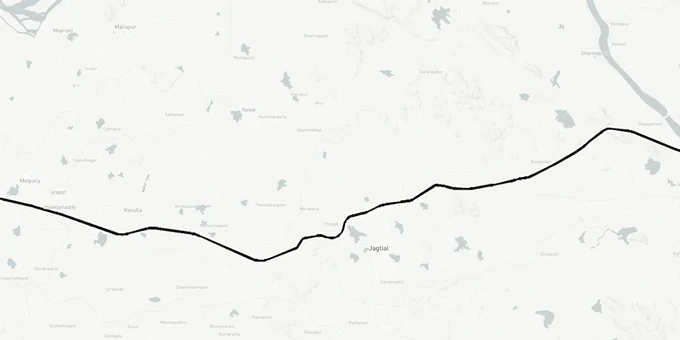
Amroor Jagitial Mancherial Expressway Preview
Try the Amroor - Jagitial - Mancherial Expressway on the map
Sign in once and explore the layer for a full day.
- No card details needed
- Find nearby verified lands for sale
Overview
The Amroor-Jagitial-Mancherial Expressway is a 131.8-km, four-lane greenfield highway on NH-63, sanctioned under the Bharatmala Pariyojana scheme in 2016 at an estimated cost of ₹3,000 crore, later revised to ₹5,354 crore. NHAI (National Highways Authority of India) divided the project into four construction packages under the Hybrid Annuity Model, with tenders floated in January 2024. The corridor passes through Nizamabad, Jagtial and Mancherial districts in Telangana. As of October 2025, land acquisition is stalled by active High Court proceedings.
Three Alignments, One High Court Stay: What Buyers Near Jagitial and Mancherial Must Know
This project has the most troubled alignment history of any highway currently under land acquisition in northern Telangana. NHAI changed the NH-63 alignment three times before sending it to New Delhi for approval, and each revision created a different set of affected plots.
The first alignment proposed widening the existing road on the right side from Mancherial to Armoor. The second followed the existing Mancherial-Armoor road but was abandoned because it would have demolished houses in Jagtial, Metpalli, Koratla, Dharmapuri and Luxettipet towns on a large scale. The third alignment, the one currently under litigation, passes through agricultural fields on the banks of the Godavari river in Luxettipet and Hajipur mandals, with bypass roads proposed at Gudem and Mulkalla. Farmers from Hajipur, Luxettipet and Dandepalli mandals approached the Telangana High Court opposing acquisition of their fields in Gudem, Gampalapalli, Thimmapur and Pothepalli villages. The court reserved its verdict and directed NHAI to halt further expansion work pending orders. As of October 2025, NHAI had filed a counter petition and the Cabinet committee proposal was still awaiting a decision.
The consequence for buyers is direct: the final acquisition boundary has not been legally settled. NHAI officials confirmed about 40% of the alignment was changed from its earlier version. Around 1,527 acres across 17 villages in Mancherial district alone were identified under one earlier plan; those boundaries shifted again under the third. A plot that appeared safe under the second alignment may fall inside the third.
The table below shows the four construction packages for which NHAI floated tenders in January 2024.
Package
Stretch
Length
Tender ID
I
Armoor to Medpally
35.9 km
2023\\_NHAI\\_179817\\_1
II
Medpally to Jagitial
28.7 km
2023\\_NHAI\\_179824\\_1
III
Jagitial to Rayapatnam
31.9 km
2023\\_NHAI\\_179823\\_1
IV
Rayapatnam to Mancherial
35.4 km
2023\\_NHAI\\_179822\\_1
Package
Stretch
Length
Tender ID
I
Armoor to Medpally
35.9 km
2023\\_NHAI\\_179817\\_1
II
Medpally to Jagitial
28.7 km
2023\\_NHAI\\_179824\\_1
III
Jagitial to Rayapatnam
31.9 km
2023\\_NHAI\\_179823\\_1
IV
Rayapatnam to Mancherial
35.4 km
2023\\_NHAI\\_179822\\_1
The combined tender value is ₹2,530 crore. Work was scheduled to begin in March 2025 but the High Court stay stopped it. Until the court rules, no buyer near Hajipur or Luxettipet should treat any plot as confirmed outside the acquisition strip.
Godavari Corridor, Hajipur and the NALA (Non-Agricultural Lands Assessment) Conversion Trap Near Mancherial
The Godavari river corridor through Hajipur mandal is where the alignment changes created the sharpest value distortion. Plots marketed as highway-adjacent under the first alignment were no longer near any proposed route after the second revision. Plots that appeared untouched under the second alignment now sit directly inside the third alignment's proposed acquisition zone in villages like Mulkalla, Vempalli and Rangapet.
Independently of the acquisition boundary question, agricultural land near this corridor in Jagitial and Mancherial districts carries a blanket regulatory requirement: NALA conversion. Under the Telangana Non-Agricultural Lands Assessment Act of 1963, no agricultural land can be used for residential, commercial or industrial purposes without prior permission from the competent authority and payment of conversion tax. Applications go through MeeSeva (Telangana's government services portal) centres, with the Tahsildar and Deputy Tahsildar as competent authorities. In areas outside the Greater Hyderabad Municipal Corporation, the NALA tax is 9% of the basic value of the land. A deemed or fraudulent conversion carries a penalty equal to 50% of the conversion fee. Buying agricultural land near Mancherial without checking NALA status first means you may be unable to obtain building permission, a layout approval or a factory licence on the same plot after purchase.
A separate controversy in January 2025 involved acquisition for a proposed industrial and IT hub at Vempalli, Mulkalla and Pochampahad in Hajipur mandal, where farmers alleged compensation of ₹13.50 lakh per acre was fixed informally and that the process began without statutory gazette notifications. The Collector's intervention was sought.
The table below maps investable and at-risk zones along this corridor.
Zone
NH-63 Exposure
Primary Risk
Status
Hajipur, Mulkalla, Gampalapalli
Directly inside third alignment
High Court stay active
High risk
Luxettipet, 27-km bypass stretch
Active litigation; NHAI says acquisition can proceed
NHAI counter-petition pending
High risk
Jagitial town periphery
Bypassed under third alignment
NALA conversion mandatory for all ag land
Moderate
Armoor-Medpally fringe (Package I)
83.895 ha identified; bypass roads at Padigel, Anksapur, Kukunoor, Morthad, Kammarpally
Land acquisition in progress
Moderate
Agricultural land in Hajipur mandal marketed as "near the river highway alignment" is the single riskiest investment on this corridor. Until the High Court delivers its final order, the legal status of that strip is unresolved.
Was this layer helpful?
Anything wrong, outdated, or missing we want to hear it.
For Land Owners & Agents
Looking to sell your land in Telangana?
I want to sell my land in Telangana
10:32
Plz share your Land's location - We will list it on 1acre map, for Free.
10:32

For Land Buyers
Browse all verified lands & plots in Telangana
Every listing goes through our Preliminary Verification Process.
More Layers in Telangana
See all 22 layers
FCDA Masterplan — Bharat Future City Zone, Hyderabad
View FCDA Bharat Future City zone as a live map overlay — check future city development zones for free on 1acre.in. FCDA...

Hyderabad HMDA Masterplan: Zone Check and Land Use Guide
View Hyderabad Masterplan as a live map overlay – check any plot's land use zone for free on 1acre.in. Hyderabad masterp...
Warangal Masterplan: WUDA Zone Check and Land Use Guide
View Warangal Masterplan as a live map overlay – check any plot's land use zone for free on 1acre.in. Warangal KUDA mast...
More Layers in Telangana
FCDA Masterplan — Bharat Future City Zone, Hyderabad
View FCDA Bharat Future City zone as a live map overlay — check future city development zones for free on 1acre.in. FCDA...
Hyderabad HMDA Masterplan: Zone Check and Land Use Guide
View Hyderabad Masterplan as a live map overlay – check any plot's land use zone for free on 1acre.in. Hyderabad masterp...
Warangal Masterplan: WUDA Zone Check and Land Use Guide
View Warangal Masterplan as a live map overlay – check any plot's land use zone for free on 1acre.in. Warangal KUDA mast...