Mancherial - Warangal Expressway
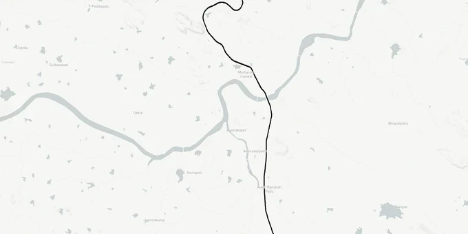
Mancherial Warangal Expressway Preview
Try the Mancherial - Warangal Expressway on the map
Sign in once and explore the layer for a full day.
- No card details needed
- Find nearby verified lands for sale
Overview
The Mancherial-Warangal Expressway is a 112-km, four-lane access-controlled greenfield highway on NH-163G, forming the central Telangana section of the 405-km Nagpur-Vijayawada Economic Corridor under Bharatmala Pariyojana Phase-I. NHAI (National Highways Authority of India) contracted all three construction packages to Megha Engineering and Infrastructures Ltd. (MEIL) in March 2023 at a combined cost of ₹3,441 crore. The corridor starts at Narva village in Jaipur mandal, Mancherial, and ends at Oorugonda village near Warangal. As of May 2026, no construction commencement has been confirmed. The September 2025 CM review ordered land acquisition disputes resolved by October 2025; resolution status remains unconfirmed.
Contracts Awarded in 2023, Still Not Started in 2025: The Land Acquisition Blockage on NH-163G
A contract award by NHAI does not mean land acquisition is complete. That distinction is the single most important fact for anyone buying near this corridor.
All three Mancherial-Warangal packages were awarded to MEIL in March 2023 with a two-year construction deadline. As per NHAI's own project status document dated January 2025, all three remain "awarded but not started." The reason is land acquisition. The NH-163G corridor, covering approximately 275 km across Telangana, was flagged as a major casualty of stalled land acquisition in a letter from Union Minister G. Kishan Reddy to the Telangana Chief Minister in March 2023. The Mancherial-Warangal section (₹3,441 crore) was explicitly named as one of the blocked projects.
The compensation dispute compounds the delay. In July 2024, lawyers representing farmers whose land was notified for the 112-km corridor from Narva to Oorugonda submitted representations to the Mancherial Collector, arguing that land compensation rates had not been revised since 2013. Under the National Highways Act, compensation is based on market value at the time of the Section 3A notification, assessed using the previous three years' sale data. When those reference values are frozen at 2013 prices, farmers in a district where coal-belt land values have moved significantly receive compensation that bears no relationship to current market price. The Telangana CM held a review meeting in September 2025 and ordered all pending highway land acquisition cases to be resolved by October 2025, but as of that review, court cases were still pending in multiple districts and compensation fund release from NHAI's competent authority remained delayed.
The table below shows the three construction packages under which MEIL holds contracts for the Mancherial-Warangal section.
Package
Stretch
Length
Contract Value
I
Narva (Ch.3.834 km) to Puttapaka (Ch.35.300 km)
31.5 km
₹873.36 crore
II
Puttapaka (Ch.35.300 km) to Pangidipalle (Ch.72.350 km)
37.1 km
₹881.57 crore
III
Pangidipalle (Ch.72.350 km) to Oorugonda (Ch.112.240 km)
39.9 km
₹852.22 crore
Package
Stretch
Length
Contract Value
I
Narva (Ch.3.834 km) to Puttapaka (Ch.35.300 km)
31.5 km
₹873.36 crore
II
Puttapaka (Ch.35.300 km) to Pangidipalle (Ch.72.350 km)
37.1 km
₹881.57 crore
III
Pangidipalle (Ch.72.350 km) to Oorugonda (Ch.112.240 km)
39.9 km
₹852.22 crore
Any plot in Narva, Jaipur mandal, Puttapaka, or Pangidipalle that sits within the greenfield acquisition strip has been notified for acquisition and carries a live compensation claim. The High Court has received land acquisition cases from this corridor. A buyer who purchases within the notified strip after the Section 3A notification date does not inherit the compensation; that right stays with the original owner at notification time.
Narva to Oorugonda: Where the Investment Case Is Real and Where It Is Not
The greenfield nature of this highway is its defining investment characteristic. Unlike a brownfield upgrade that widens an existing road, this corridor cuts entirely new land between Mancherial and Warangal. That means the acquisition strip is not alongside a road you can see today. It runs through agricultural land across Jaipur mandal in Mancherial district and extends through villages into Hanamkonda district near Warangal. Plots that look untouched today may sit directly inside a boundary that has been gazette-notified and is pending physical handover.
The legitimate investment zone is land outside the acquisition strip, with full NALA conversion done. Under the Telangana Non-Agricultural Lands Assessment Act of 1963, no agricultural land can be used for residential, commercial or industrial purposes without prior conversion approval from the Revenue Officer. In non-GHMC areas like Mancherial and Warangal districts, the NALA tax is 9% of the basic value of the land. Applications go through MeeSeva centres, with the Tahsildar as the competent authority. If this step is skipped, you cannot legally obtain building permission, a layout approval, or factory clearance on the same plot.
The table below maps zones along the NH-163G Mancherial-Warangal corridor by investment risk.
Zone
Corridor Exposure
Primary Risk
Status
Narva-Jaipur mandal fringe
Package I start point; greenfield acquisition notified
Compensation dispute; acquisition not complete
High risk
Puttapaka-Pangidipalle mid-corridor
Packages I-II junction; all ag land
NALA conversion mandatory; acquisition active
High risk
Oorugonda periphery near Warangal
Package III endpoint; Warangal city fringe
Less acquisition risk at periphery; check survey number against gazette
Moderate
Mancherial town fringe (Narva exit side)
Adjacent to corridor start, outside greenfield strip
NALA conversion needed; clear of acquisition if survey number verified
Moderate
The most misunderstood investment pitch on this corridor is farmland near Puttapaka or Pangidipalle, sold as "adjacent to the expressway." On a fully greenfield alignment, adjacent to the road means adjacent to the acquisition strip, not adjacent to infrastructure that already exists. Until NHAI completes land handover and MEIL begins physical work, those plots carry both acquisition risk and NALA risk simultaneously.
Was this layer helpful?
Anything wrong, outdated, or missing we want to hear it.
For Land Owners & Agents
Looking to sell your land in Telangana?
I want to sell my land in Telangana
10:32
Plz share your Land's location - We will list it on 1acre map, for Free.
10:32

For Land Buyers
Browse all verified lands & plots in Telangana
Every listing goes through our Preliminary Verification Process.
More Layers in Telangana
See all 22 layers
FCDA Masterplan — Bharat Future City Zone, Hyderabad
View FCDA Bharat Future City zone as a live map overlay — check future city development zones for free on 1acre.in. FCDA...

Hyderabad HMDA Masterplan: Zone Check and Land Use Guide
View Hyderabad Masterplan as a live map overlay – check any plot's land use zone for free on 1acre.in. Hyderabad masterp...
Warangal Masterplan: WUDA Zone Check and Land Use Guide
View Warangal Masterplan as a live map overlay – check any plot's land use zone for free on 1acre.in. Warangal KUDA mast...
More Layers in Telangana
FCDA Masterplan — Bharat Future City Zone, Hyderabad
View FCDA Bharat Future City zone as a live map overlay — check future city development zones for free on 1acre.in. FCDA...
Hyderabad HMDA Masterplan: Zone Check and Land Use Guide
View Hyderabad Masterplan as a live map overlay – check any plot's land use zone for free on 1acre.in. Hyderabad masterp...
Warangal Masterplan: WUDA Zone Check and Land Use Guide
View Warangal Masterplan as a live map overlay – check any plot's land use zone for free on 1acre.in. Warangal KUDA mast...