Alwar UIT Masterplan 2031: Zone Check and Land Use Guide
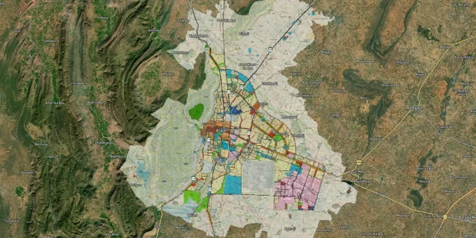
Alwar Masterplan Preview
Try the Alwar UIT Masterplan 2031 on the map
Sign in once and explore the layer for a full day.
- No card details needed
- Find nearby verified lands for sale
Overview
The Alwar Master Plan 2051 is the long-range development blueprint prepared by the Urban Improvement Trust (UIT) Alwar under the Government of Rajasthan. It covers the city's current urban area of 48.14 sq km and absorbs 86 surrounding villages in phases through 2051, with a projected population of over 1.2 million. This page covers the five planning zones, the Aravalli Notification restrictions that govern large parts of Alwar district, and the growth corridors where the plan directly shapes land value.
Aravalli Notification: The Single Biggest Risk in Alwar Plot Zone Checks
Land buyers in Alwar face a regulatory trap that exists nowhere else in India at this scale: the MoEF&CC Notification dated 7 May 1992 prohibits specified construction and mining activities across Alwar district without prior environmental clearance. The Supreme Court and the National Green Tribunal have both issued active orders against illegal construction in thegair mumkin pahar(uncultivable hill) areas of Alwar, including a 2021 NGT direction to the Rajasthan Chief Secretary to nominate a senior officer to monitor demolitions. In December 2025, the Supreme Court again ordered a complete ban on new mining leases across the Aravalli range, with Alwar district collector Artika Shukla launching a joint enforcement operation as recently as January 2026.
For the buyer, this has one practical consequence: any plot touching an Aravalli hill, supporting slope, or forest block in Alwar must have explicit MoEF&CC clearance before construction begins. A UIT patta or a revenue department Khata alone is not enough.
Five Planning Zones Under UIT Alwar Masterplan 2031
The table below shows the five planning zones UIT Alwar uses in its master plans, drawn from the plan's documented structure:
Zone
Primary Use
Construction Permitted?
Key Risk
Old City Zone
Mixed residential-commercial
Yes, with UIT sanction
High congestion, narrow roads
Moti Dungri Zone
Residential expansion
Yes, with UIT layout approval
Aravalli buffer overlaps
Industrial Zone
MIA, OIA and extensions
Industrial only
Residential use strictly prohibited
Dayanand Nagar Zone
Planned residential
Yes, with UIT patta
Verify UIT vs municipal limits
Peripheral Control Zone
Agricultural/green buffer
Restricted
Most fraud happens here
The Peripheral Control Zone is where most plot fraud occurs. Brokers routinely show agricultural land in this zone as "master plan-approved residential" without UIT layout sanction. If a seller cannot show you the UIT-issued layout approval number for a peripheral plot, stop the transaction.
Alwar Growth Corridors Under Master Plan 2051: Where the Plan Changes Land Value
Alwar sits at the intersection of three of India's most significant infrastructure programs, and the Master Plan 2051 is explicitly designed to absorb their population and economic spillover.
The table below maps the corridors with confirmed infrastructure notifications:
Corridor / Locality
Infrastructure Driver
Land Use Context
Risk Flag
Bhiwadi-Neemrana-Khushkhera
DMIC Investment Region (165 sq km, 42 villages, notified 2013)
Industrial + mixed residential
Verify Bhiwadi Integrated Development Authority (BIDA) zone
Naugaon-Ramgarh
Delhi-Mumbai Expressway entry into Rajasthan at Alwar district
Farmland to urban transition
No UIT layout yet on most parcels
Neemrana-Behror
Delhi-Alwar RRTS (single phase, construction expected August 2026, commercial launch November 2031)
Residential corridor at 160 km/hr train access
RRTS not operational, Phase 2 timeline unconfirmed
Baroda Meo-Tijara
Paniyala-Alwar-Barodameo Highway (86 km, construction started March 2024)
Notified ULB, master plan in place
—
Alwar city fringe (77 villages)
Master Plan 2051 periodic village absorption every 5 years
Agricultural to residential in phases
Current zone is agricultural; conversion requires government gazette
The most misunderstood corridor is Naugaon. The Delhi-Mumbai Expressway enters Rajasthan at Munpur Karmala village in Alwar district, and developers are actively selling farm parcels here as "expressway-adjacent investment." Most of these parcels are still in agricultural use with no pending zone conversion under the Master Plan 2051. Buy land here only if you can wait for a long-horizon conversion; do not purchase expecting near-term construction rights.
Was this layer helpful?
Anything wrong, outdated, or missing we want to hear it.
For Land Owners & Agents
Looking to sell your land in Delhi?
I want to sell my land in Delhi
10:32
Plz share your Land's location - We will list it on 1acre map, for Free.
10:32

For Land Buyers
Browse all verified lands & plots in Delhi NCR
Every listing goes through our Preliminary Verification Process.
More Layers in Delhi NCR
See all 30 layers
Arogya Dham Badsa Masterplan: Zone Check and Land Use Guide
View Arogya Dham Badsa Masterplan as a live map overlay – check any plot's land use zone for free on 1acre.in. Arogya Dh...

Baghpat Baraut Khekra Masterplan: Zone Check and Land Use Guide
View Bhagpat-Baraut-Khekra Masterplan as a live map overlay – check any plot's land use zone for free on 1acre.in. Baghp...
Delhi Master Plan 2041: DDA Zone Check and Land Use Guide
View Delhi Masterplan as a live map overlay – check any plot's land use zone for free on 1acre.in. Delhi masterplan land...
More Layers in Delhi NCR
Arogya Dham Badsa Masterplan: Zone Check and Land Use Guide
View Arogya Dham Badsa Masterplan as a live map overlay – check any plot's land use zone for free on 1acre.in. Arogya Dh...
Baghpat Baraut Khekra Masterplan: Zone Check and Land Use Guide
View Bhagpat-Baraut-Khekra Masterplan as a live map overlay – check any plot's land use zone for free on 1acre.in. Baghp...
Delhi Master Plan 2041: DDA Zone Check and Land Use Guide
View Delhi Masterplan as a live map overlay – check any plot's land use zone for free on 1acre.in. Delhi masterplan land...