Noida (Jewar) Air Funnel Zones: Building Height Restrictions
Noida Air Funnel Zones Preview
Try the Noida (Jewar) Air Funnel Zones on the map
Sign in once and explore the layer for a full day.
- No card details needed
- Find nearby verified lands for sale
Overview
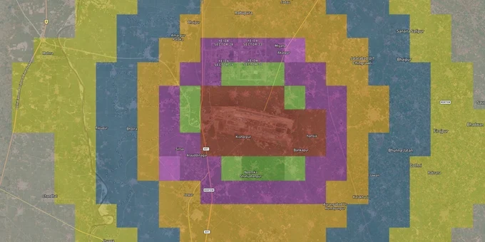
The Noida airport height restriction zone layer on 1acre maps the Airports Authority of India's Colour-Coded Zoning Map (CCZM) data for the Noida NCR region. Any plot within 20 km of Noida International Airport (Jewar) falls under Ministry of Civil Aviation GSR 751(E) Rules, 2015: no structure above the permitted height without a Height NOC from AAI.
Regulatory Red Flags in the Noida Airport Height Restriction Zone
The Airports Authority of India divides the airspace around Noida International Airport into three CCZM colour zones: Red, Yellow, and Green. Each zone sets a different Permissible Top Elevation based on your plot's proximity to the runway approach path. The figure most brokers in this market never disclose: in the Red inner funnel zone, AAI's CCZM permits a building height of just 2% of the plot's distance from the runway edge. At 1 km from the runway, your structure cannot legally exceed 20 metres. Getting this wrong does not result in a fine. It results in demolition.
Construction NOC Requirements by Funnel Zone
The table below shows what each funnel zone means for a construction NOC near Noida airport and the action required before any foundation work begins.
CCZM Colour Zone
Distance Band
Permitted Height Rule
NOC Requirement
Red
Inner approach/take-off corridor
2% of distance from runway edge (e.g., 20 m max at 1 km)
Mandatory AAI Height NOC via NOCAS portal
Yellow
Transition surface
Intermediate cap; local body checks against CCZM
NOC required if proposed height exceeds CCZM Permissible Top Elevation
Green
Outer conical zone (up to 20 km)
15 m AGL threshold under YEIDA building bylaws
AAI Height NOC required if structure exceeds 15 m AGL
The biggest documented trap in this zone is abadi land: village parcels under gram panchayat jurisdiction, outside YEIDA's notified sectors, sold informally at prices that look attractive precisely because no proper title or compliance work has been done. During an Airport Environment Management Committee meeting on 9 July 2025, NIAL and Gautam Budh Nagar district administration officials flagged rampant unauthorised development on these parcels as a direct flight safety threat. The Aircraft (Demolition of Obstructions caused by Buildings and Trees) Rules, 2023 empowers authorities to tear down any structure breaching CCZM limits with no compensation owed. AAI rejects approximately 40% of height clearance applications outright, and structures already built in violation face court-ordered removal. If a seller cannot produce a YEIDA allotment letter and a current AAI NOC together, that plot carries a risk no price can justify.
Growth Corridors Inside the Noida Airport Height Restriction Zone
The Noida airport height restriction zone is not a single flat restriction applied uniformly across Jewar. YEIDA's Master Plan 2041 divides the planning area into notified residential, commercial, industrial, and institutional sectors, each with pre-assessed height limits built into the allotment framework. In a YEIDA-notified sector, the height ceiling for your plot is already settled before you buy. Outside those notified boundaries, every dimension of compliance rests on you, with no prior authority guidance to fall back on.
The table below maps the primary growth corridors within the zone and their confirmed land-use classification under YEIDA's Master Plan 2041.
Corridor
Land Use (YEIDA Master Plan 2041)
Growth Driver
Key Risk
YEIDA Sector 22D
Residential (notified)
Plots from ₹30,000/sq yd at launch now reselling at ₹1.15–1.25 lakh/sq yd
Verify current height approval before construction
YEIDA Sectors 18 and 20
Residential (in development)
Airport-proximity housing demand; YEIDA-allotted plots
Any structure above 15 m requires AAI NOC
YEIDA Sectors 28 and 29
Commercial and Industrial
Logistics and warehousing belt along Yamuna Expressway
Height NOC mandatory for most commercial structures
Film City and airport logistics belt
Mixed Use
1,000-acre Film City project plus media and production ecosystem
Environmental clearance plus AAI height NOC required
Yamuna Expressway belt (non-notified areas)
Unclassified/Agricultural
Marketed as airport-adjacent by private sellers
No YEIDA allotment, active demolition risk
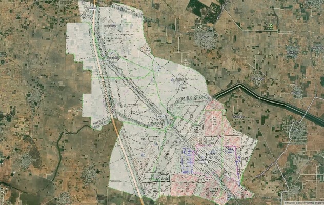
The most misread corridor is the Yamuna Expressway belt outside YEIDA-notified sectors. Sellers market these parcels as airport-adjacent investments without disclosing that they carry no YEIDA allotment letter, no RERA number, and sit inside the restricted zone without any approved building plan. YEIDA-approved plots near Jewar airport in notified sectors like 22D represent the only reliable path to the airport growth story: Greater Noida and Noida together drove 30% of NCR residential sales in H1 2025, but that demand is concentrated entirely in compliant, properly approved projects. Demand the YEIDA allotment letter, RERA registration number, and a valid AAI NOC before any token payment leaves your account.
Was this layer helpful?
Anything wrong, outdated, or missing we want to hear it.
For Land Owners & Agents
Looking to sell your land in Delhi?
I want to sell my land in Delhi
10:32
Plz share your Land's location - We will list it on 1acre map, for Free.
10:32

For Land Buyers
Browse all verified lands & plots in Delhi NCR
Every listing goes through our Preliminary Verification Process.
More Layers in Delhi NCR
See all 30 layers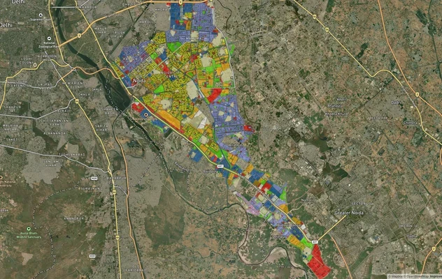
Noida Master Plan 2031: Zone Check and Land Use Guide
View Noida Masterplan as a live map overlay – check any plot's land use zone for free on 1acre.in. Noida Master Plan 203...

Alwar UIT Masterplan 2031: Zone Check and Land Use Guide
View Alwar Masterplan as a live map overlay – check any plot's land use zone for free on 1acre.in. Alwar Master Plan 205...
Arogya Dham Badsa Masterplan: Zone Check and Land Use Guide
View Arogya Dham Badsa Masterplan as a live map overlay – check any plot's land use zone for free on 1acre.in. Arogya Dh...
More Layers in Delhi NCR
Noida Master Plan 2031: Zone Check and Land Use Guide
View Noida Masterplan as a live map overlay – check any plot's land use zone for free on 1acre.in. Noida Master Plan 203...
Alwar UIT Masterplan 2031: Zone Check and Land Use Guide
View Alwar Masterplan as a live map overlay – check any plot's land use zone for free on 1acre.in. Alwar Master Plan 205...
Arogya Dham Badsa Masterplan: Zone Check and Land Use Guide
View Arogya Dham Badsa Masterplan as a live map overlay – check any plot's land use zone for free on 1acre.in. Arogya Dh...