Ghaziabad GDA Masterplan: Zone Check and Land Use Guide
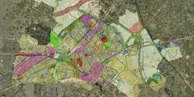
Ghaziabad Masterplan Preview
Try the Ghaziabad GDA Masterplan on the map
Sign in once and explore the layer for a full day.
- No card details needed
- Find nearby verified lands for sale
Overview
The Ghaziabad masterplan 2031 is the GIS-based Integrated Development Plan for Ghaziabad, Loni, and Modinagar/Muradnagar, approved by the Uttar Pradesh government on 23 August 2025 after seven years of revision. It covers 32,017 to 33,543 hectares and is governed by the Ghaziabad Development Authority (GDA) under the Uttar Pradesh Urban Planning and Development Act, 1973. The plan designates TOD zones along eight RRTS stations and two Metro corridors, with a draft status now superseded by formal UP government notification. This page covers the unauthorised colony risk, the TOD and SDA corridors driving real demand, and how to verify any plot before purchase.
Duhai to Raj Nagar Extension: Where Ghaziabad Masterplan 2031 Zone Classification Creates Real Investment Demand
The masterplan 2031 builds its investment thesis around transit proximity. The two Special Development Areas (SDAs) at Guldhar (510.56 hectares) and Duhai (549.5 hectares) carry provisions for higher FAR and mixed land use that no other zone in the plan currently offers. FAR in TOD zones rises from the standard 1.5 to 5, a multiplier that substantially increases developable density on the same land footprint. Raj Nagar Extension, Duhai, and Guldhar are the three corridors explicitly identified in the approved plan as emerging growth pockets for both residential and commercial development.
The eight RRTS stations in Ghaziabad district (Sahibabad, Ghaziabad, Guldhar, Duhai, Duhai Depot, Muradnagar, Modinagar South, and Modinagar North) each carry a 1.5 km influence zone classified as TOD. Metro Blue Line and Red Line corridors carry a 500m TOD influence zone. Plots outside these defined radii, even if adjacent to a station or corridor, do not carry TOD zone FAR entitlements and must be valued at standard residential FAR instead.
The table below shows the corridors confirmed under the Ghaziabad masterplan 2031 and what the zone designation means for a buyer's decision.
Corridor
Zone / Classification
Infrastructure Anchor
Key Buyer Risk
Duhai
SAD + TOD (RRTS)
Duhai RRTS station and depot
Confirm plot is within SDA boundary, not just adjacent to it
Guldhar
SAD + TOD (RRTS)
Guldhar Namo Bharat station
Higher FAR only within SDA; verify khasra against SDA map
Raj Nagar Extension
Residential / TOD edge
Red Line Metro proximity
Confirm 500m radius alignment; standard FAR applies beyond the boundary
Sahibabad
TOD (RRTS)
Sahibabad Namo Bharat station
Industrial zone adjacency exists; verify zone code for specific plot
Modinagar and Muradnagar
Residential (6,875 ha)
RRTS stations Modinagar N and S
New expansion boundary villages not yet fully notified; verify inclusion
Loni
Residential (7,980 ha)
EPE and DME connectivity
Expansion villages pending formal notification; patta alone is insufficient
Raj Nagar Extension is the most commonly misrepresented corridor. Plots here are routinely marketed as TOD-zone assets based on proximity to the Red Line Metro, when the 500m influence radius may not reach the specific khasra being offered. Check the exact distance from the nearest metro station boundary, not from the station entrance, before accepting any TOD FAR figure.
Was this layer helpful?
Anything wrong, outdated, or missing we want to hear it.
For Land Owners & Agents
Looking to sell your land in Delhi?
I want to sell my land in Delhi
10:32
Plz share your Land's location - We will list it on 1acre map, for Free.
10:32

For Land Buyers
Browse all verified lands & plots in Delhi NCR
Every listing goes through our Preliminary Verification Process.
More Layers in Delhi NCR
See all 30 layers
Alwar UIT Masterplan 2031: Zone Check and Land Use Guide
View Alwar Masterplan as a live map overlay – check any plot's land use zone for free on 1acre.in. Alwar Master Plan 205...
Arogya Dham Badsa Masterplan: Zone Check and Land Use Guide
View Arogya Dham Badsa Masterplan as a live map overlay – check any plot's land use zone for free on 1acre.in. Arogya Dh...

Baghpat Baraut Khekra Masterplan: Zone Check and Land Use Guide
View Bhagpat-Baraut-Khekra Masterplan as a live map overlay – check any plot's land use zone for free on 1acre.in. Baghp...
More Layers in Delhi NCR
Alwar UIT Masterplan 2031: Zone Check and Land Use Guide
View Alwar Masterplan as a live map overlay – check any plot's land use zone for free on 1acre.in. Alwar Master Plan 205...
Arogya Dham Badsa Masterplan: Zone Check and Land Use Guide
View Arogya Dham Badsa Masterplan as a live map overlay – check any plot's land use zone for free on 1acre.in. Arogya Dh...
Baghpat Baraut Khekra Masterplan: Zone Check and Land Use Guide
View Bhagpat-Baraut-Khekra Masterplan as a live map overlay – check any plot's land use zone for free on 1acre.in. Baghp...