Greater Bhiwadi BIDA Masterplan 2031: Zone Check and Land Use Guide
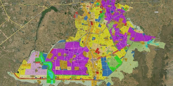
Bhiwadi Masterplan Preview
Try the Greater Bhiwadi BIDA Masterplan 2031 on the map
Sign in once and explore the layer for a full day.
- No card details needed
- Find nearby verified lands for sale
Overview
The Bhiwadi Master Plan 2031, formally the Greater Bhiwadi Master Plan for the Bhiwadi-Tapookara-Khushkhera Complex, is prepared by Rajasthan's Town Planning Department under the Rajasthan Urban Improvement Act, 1959. It spans 251 sq km across 99 notified revenue villages in Khairthal-Tijara district (carved out of Alwar in August 2023), allocating 21,483 hectares across residential, industrial, mixed-use, and special-use zones. Every Bhiwadi Masterplan 2031 land buying decision starts with one question: which zone does your survey number sit in? This page covers the zone codes, the regulatory traps buyers walk into, and the corridors where zoning actually moves land value.
Industrial Zone Creep: The Biggest Regulatory Trap in Bhiwadi Masterplan 2031 Land Buying
Most buyers arrive in Bhiwadi expecting a clean residential market. What they find is different. The Greater Bhiwadi Master Plan 2031 reserves 24.9% of the total urbanisable area, roughly 5,355 hectares, for industrial use. That single number is larger than the entire residential allocation, and it explains why the Bhiwadi industrial zone land rules catch so many buyers off guard.
Zone Permissions and Conversion Requirements Under BIDA Masterplan 2031
The table below shows what each zone permits and where conversion becomes mandatory.
Zone
Permitted Primary Use
Residential Construction Allowed?
Conversion Required?
Residential
Housing sectors, avg 60 ha each
Yes
No
Mixed Use
Retail plus residential along Alwar Road
Yes, with commercial ground floor
No, within Mixed Use boundary
Industrial
Manufacturing, Rajasthan State Industrial Development and Investment Corporation (RIICO)-allocated industry
No
Yes, CLU from BIDA mandatory
Abadi Area
99 notified village settlements
Existing structures only
Regularisation needed for new builds
Special Uses
Corporate Park, Transit-Oriented Development (TOD), Ecological Conservation
No
No conversion pathway
The sharpest risk is abadi area land Bhiwadi plot purchase. Sellers inside Tapookara, Khushkhera, and Chaupanki routinely present village land as approved residential. The plan classifies all 99 revenue villages as abadi, but that status does not make them buildable for new residential use. Any abadi plot sitting within an industrial zone boundary needs a formal Change of Land Use order from the Bhiwadi Integrated Development Authority (BIDA) before a single foundation can legally go in. Demand the CLU certificate before signing the sale deed, not as an afterthought once money has changed hands.
Tapookara, Chaupanki, Kahrani: Which Corridors Does Bhiwadi Masterplan 2031 Actually Favour?
Not every corridor in Greater Bhiwadi carries the same risk profile. The plan structures growth around industrial nodes, but it carves out specific zones where residential and mixed use investment has a genuine legal foundation.
The Tapookara Khushkhera Chaupanki corridor land picture varies sharply between localities. The table below maps the four main corridors against their zone status and the primary risk each carries.
Corridor
Zone Classification
Growth Driver
Primary Risk
Bhiwadi North
Residential plus Mixed Use
Established base, RRTS station at Matila village
Entry prices already reflect the premium
Tapookara
Industrial plus Abadi
Honda plant, RIICO road link to Kasaula
Abadi plots sold as residential without a CLU
Khushkhera
Industrial
Delhi-Mumbai Industrial Corridor (DMIC) investment region, Bhiwadi-Neemrana corridor
Residential use needs full CLU conversion
Chaupanki / Kahrani
Industrial plus Residential fringe
NH-8 access, Corporate Park zone
Boundary disputes between zone types
The Bhiwadi mixed use zone Alwar Road plot corridor is the plan's most coherent residential bet. Mixed use zoning was placed along Alwar Road deliberately, to channel commercial pressure into a defined strip and keep the residential sectors behind it clean. That design logic holds.
Tapookara looks compelling on paper. Honda plant proximity and the RIICO road link to Kasaula create real industrial activity nearby. The problem is that RIICO acquisition work in the area displaced village land into a legal limbo that persisted for years. Before committing any funds to a Tapookara survey number, pull the RIICO acquisition records and confirm the land is clear.
The 164 km Delhi-Alwar RRTS corridor is approved but has not broken ground as of April 2026. Construction is expected to start in August 2026, with commercial launch targeted November 2031. The master plan reserves 22 hectares near Matila village for a future station. Land in the residential and mixed use zones within reach of that corridor has a zoning foundation and a national infrastructure commitment behind it — but this is a long-horizon bet, not a near-term operational asset.
Was this layer helpful?
Anything wrong, outdated, or missing we want to hear it.
For Land Owners & Agents
Looking to sell your land in Delhi?
I want to sell my land in Delhi
10:32
Plz share your Land's location - We will list it on 1acre map, for Free.
10:32

For Land Buyers
Browse all verified lands & plots in Delhi NCR
Every listing goes through our Preliminary Verification Process.
More Layers in Delhi NCR
See all 30 layers
Greater Noida Masterplan: Zone Check and Land Use Guide
View Greater Noida Masterplan as a live map overlay – check any plot's land use zone for free on 1acre.in. Greater Noida...

Alwar UIT Masterplan 2031: Zone Check and Land Use Guide
View Alwar Masterplan as a live map overlay – check any plot's land use zone for free on 1acre.in. Alwar Master Plan 205...
Arogya Dham Badsa Masterplan: Zone Check and Land Use Guide
View Arogya Dham Badsa Masterplan as a live map overlay – check any plot's land use zone for free on 1acre.in. Arogya Dh...
More Layers in Delhi NCR
Greater Noida Masterplan: Zone Check and Land Use Guide
View Greater Noida Masterplan as a live map overlay – check any plot's land use zone for free on 1acre.in. Greater Noida...
Alwar UIT Masterplan 2031: Zone Check and Land Use Guide
View Alwar Masterplan as a live map overlay – check any plot's land use zone for free on 1acre.in. Alwar Master Plan 205...
Arogya Dham Badsa Masterplan: Zone Check and Land Use Guide
View Arogya Dham Badsa Masterplan as a live map overlay – check any plot's land use zone for free on 1acre.in. Arogya Dh...