Noida Master Plan 2031: Zone Check and Land Use Guide
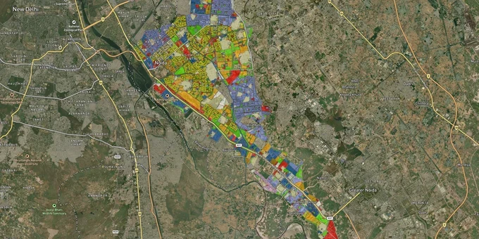
Noida Masterplan Preview
Try the Noida Master Plan 2031 on the map
Sign in once and explore the layer for a full day.
- No card details needed
- Find nearby verified lands for sale
Overview
The Noida Master Plan 2031 is the operative land-use document for Noida, prepared and enforced by the New Okhla Industrial Development Authority (NOIDA). It covers a planned urbanisable area of 15,280 hectares across residential, commercial, industrial, institutional, recreational, and village abadi zones. Implemented in 2011 with a horizon year of 2031, it remains the primary reference for zone classification before buying any plot in Noida. This layer on 1acre requires a Premium subscription and maps every sector's designated land use, helping buyers verify zone status before committing funds.
Village Abadi Zone and Illegal Layouts: The Biggest Trap in Noida Master Plan 2031 Land Buying
Noida's single most dangerous buying risk is the village abadi zone. Under the Noida Master Plan 2031 zoning regulations, the zones are: Resd (Residential), Comm (Commercial), Ind (Industrial), Insti (Institutional), Whole (Wholesale/Mandi/Warehousing), PZ (NEPZ/EPZ), Trans (Transportation), Green Belt, Rec.Grn (Recreational Green/Park), Agri (Agriculture), and Abadi (Village Abadi/Village Extension). Land classified as Abadi is governed by gram panchayat rules, sits outside NOIDA Authority's planned sector framework, and cannot legally host multi-storey residential or commercial projects without board-level special permission.
The table below shows which uses are permissible, conditionally permissible, or prohibited in the key zones most relevant to buyers.
Zone
Single Plot/Flat
Group Housing
Commercial Retail
Industrial
Notes
Resd
Permissible
Permissible
Conditional
Not Permissible
Standard residential sectors
Comm
Conditional
Conditional
Permissible
Not Permissible
Mixed-use allowed on large plots
Abadi
Conditional
Not Permissible
Conditional
Not Permissible
Gram panchayat land, high fraud risk
Agri
Not Permissible
Not Permissible
Not Permissible
Not Permissible
No residential construction permitted
Green Belt
Not Permissible
Not Permissible
Not Permissible
Not Permissible
Flood plain and recreational reserve
The scale of violation here is not marginal. Since January 2024, NOIDA Authority reclaimed approximately 2.3 million square metres of encroached government land (valued at over ₹2,200 crore), all of it earmarked under Master Plan 2031. As of late 2024, more than 70,000 builder floor flats were under construction in over 2,000 illegal residential projects across Noida and Greater Noida, with 75% already sold to buyers. The NGT banned all such illegal construction via OA No. 329/2024 (order dated December 9, 2024), and the Supreme Court in C.A. No. 14604 of 2024 explicitly ruled that property registration does not regularise unauthorised construction. Salarpur and villages in Greater Noida West (Bisrakh, Jalpura) are among the documented hotspots.
The leasehold point is equally misunderstood. All NOIDA Authority-allotted plots and flats are leasehold (99 years): this is standard and legally safe. What is not safe is land in Abadi or agricultural zones that is being sold on the street as "freehold." In Noida, any genuinely freehold claim on a private plot outside the Abadi zone is a red flag, not a benefit.
Noida Expressway and IT Corridor: Where Master Plan 2031 Zoning Drives Land Value
The Noida Master Plan 2031 designates specific sectors as commercial centres, IT/ITES hubs, and high-density residential zones, and zone classification directly determines what can be built and at what density. Not every sector offers the same upside.
The table below maps the key corridors as classified under the Master Plan 2031, their zone designation, and the growth driver behind each.
Corridor / Locality
Zone (Master Plan 2031)
Growth Driver
Known Risk
Sectors 62, 67, 125, 135
Information Technology / IT-Enabled Services (IT/ITES) / Institutional
Established IT park clusters, Special Economic Zone (SEZ)-notified
High land prices, limited undeveloped stock
Sectors 32 and 25A (City Centre)
Commercial
98.59 hectares allocated as primary commercial hub
Premium pricing; high-end office/retail, not residential plots
Sectors 94, 124, 78, 105, 108, 135, 144
Commercial (proposed centres)
Expressway junctions, arterial road nodes
Some sectors still under development
Sectors 75, 76, 77, 113, 115, 116, 117, 118
High-density Residential (above 500 persons per hectare (pph))
Group housing, metro connectivity
Density above 1,650 persons per hectare on group housing plots
Sector 150 and 152
Recreational Green / Low-density Residential
NH-2 to Expressway road link proposed; low-density by plan
Sector 150 is among the largest green patches; development rights limited
Sectors 160 and 146
Rail Freight Corridor (proposed)
Mumbai-Delhi Dedicated Freight Corridor alignment
Land around freight yard not residential
Southern belt (Sultanpur, Shahdara area)
Agriculture / Plantation
Rural land bank
No permissible residential use; Agri zone prohibits construction
The most misread corridor is Sector 150. Brokers routinely market it as a premium residential zone, but the Master Plan classifies the bulk of it as recreational/green space. What is permissible there is low-density construction, not standard group housing schemes with high Floor Area Ratio (FAR). Always cross-reference the sector plan map on the NOIDA Authority website before accepting any broker's zone description.
Was this layer helpful?
Anything wrong, outdated, or missing we want to hear it.
For Land Owners & Agents
Looking to sell your land in Delhi?
I want to sell my land in Delhi
10:32
Plz share your Land's location - We will list it on 1acre map, for Free.
10:32

For Land Buyers
Browse all verified lands & plots in Delhi NCR
Every listing goes through our Preliminary Verification Process.
More Layers in Delhi NCR
See all 30 layers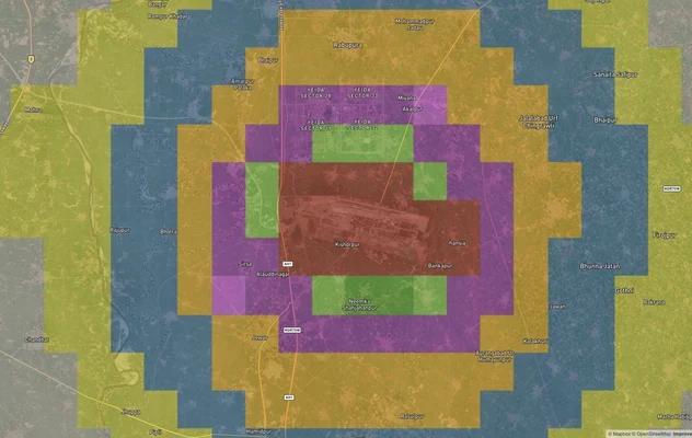
Noida (Jewar) Air Funnel Zones: Building Height Restrictions
View Noida Air Funnel Zones on a live map – check height clearance restrictions on any plot for free on 1acre.in. Noida ...

Alwar UIT Masterplan 2031: Zone Check and Land Use Guide
View Alwar Masterplan as a live map overlay – check any plot's land use zone for free on 1acre.in. Alwar Master Plan 205...
Arogya Dham Badsa Masterplan: Zone Check and Land Use Guide
View Arogya Dham Badsa Masterplan as a live map overlay – check any plot's land use zone for free on 1acre.in. Arogya Dh...
More Layers in Delhi NCR
Noida (Jewar) Air Funnel Zones: Building Height Restrictions
View Noida Air Funnel Zones on a live map – check height clearance restrictions on any plot for free on 1acre.in. Noida ...
Alwar UIT Masterplan 2031: Zone Check and Land Use Guide
View Alwar Masterplan as a live map overlay – check any plot's land use zone for free on 1acre.in. Alwar Master Plan 205...
Arogya Dham Badsa Masterplan: Zone Check and Land Use Guide
View Arogya Dham Badsa Masterplan as a live map overlay – check any plot's land use zone for free on 1acre.in. Arogya Dh...