Rewari Masterplan 2031: DTCP Zone Check and Land Use Guide
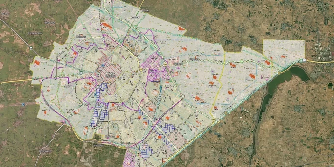
Rewari Masterplan Preview
Try the Rewari Masterplan 2031 on the map
Sign in once and explore the layer for a full day.
- No card details needed
- Find nearby verified lands for sale
Overview
Before buying land in Rewari, the Rewari Masterplan 2031 land buying decision starts with one question: what zone is your survey number in? The Final Development Plan (FDP) 2031 was notified by the Haryana Government vide Gazette Notification No. 492 dated 3 June 2020, administered by the Department of Town and Country Planning (DGTCP), Haryana. Rewari sits 82 km southwest of Delhi inside the NCR boundary, covering city, industrial, and rural pockets with very different development rights. This page, available via 1acre's Premium map layer, shows you exactly where that zone boundary falls on your plot.
Why the Wrong Zone in Rewari Can Kill Your Building Permission
The single biggest trap for buyers in Rewari's controlled area is treating a Jamabandi entry showing agricultural use as a blank canvas. It is not. Under the Punjab Scheduled Roads and Controlled Areas Restriction of Unregulated Development Act, 1963, any land in a declared controlled area that you want to convert from agricultural to residential, commercial, or industrial use requires formal Change of Land Use (CLU) permission from the Director, DGTCP, Haryana. Without CLU, construction is illegal regardless of what the sale deed says.
This table shows the land use categories that appear in Rewari's controlled area and what they mean for buyers.
Land Use Zone
Can You Build a House Without CLU?
CLU Route
Key Risk
Residential (urbanizable)
Yes, if licensed colony or HSVP sector
Not required if already zoned
Verify license number with DGTCP
Agriculture zone (controlled area)
No
Apply Form CLU-I to DGTCP Director
Industrial units prohibited in agriculture zone of High/Hyper Potential zones
Industrial (IMT/HSIIDC)
Only for permitted industrial use
Not applicable for housing
Residential use on industrial plot is a violation
Agriculture (outside controlled area)
Governed by revenue laws only
State-level decision
Less regulated but harder to sell
Specific zone area figures in hectares from the FDP 2031 document could not be extracted, as the official PDF is robot-blocked. The mistake brokers exploit here is selling plots in unlicensed colonies by showing a Jamabandi with mutation entries. A mutation in the Jamabandi confirms ownership transfer. It does not confirm zone status or building permission. If a seller cannot show you a DGTCP license number or a CLU order for the survey number you are buying, walk away.
Dharuhera, Bawal, and Rewari City: Three Very Different Bets
The Rewari district has three distinct investment corridors, and they carry different risk profiles depending on what the Rewari Master Plan 2031 assigns to each.
Rewari City and HSVP Sectors:The urbanizable core has HSVP (formerly HUDA) sectors with notified residential zones. These are the lowest-risk plots: clear zone classification, licensed infrastructure, and straightforward title chains. The trade-off is premium pricing compared to peripheral areas.
Dharuhera (19 km from Rewari city, on NH-48):Dharuhera's land use in the Dharuhera FDP integrates 725 hectares residential, 626 hectares industrial, and 87 hectares commercial. It sits on the Gurugram-Manesar-Bawal-Dharuhera-Rewari Highway Corridor Zone earmarked under the Delhi NCR Master Plan 2041. Hero MotoCorp, Amul, and Carlsberg anchor its industrial base. Residential land adjacent to the NH-48 strip commands a real premium, but the town still lacks adequate public infrastructure, which keeps long-term rental yield uncertain.
IMT Bawal (14 km from Rewari city, on NH-48):Bawal is the Rewari district's primary industrial land market. HSIIDC manages Phases I-IV of IMT Bawal with reserve prices around Rs 16,300 per sq meter for industrial plots (2024 auction data). The Punjab and Haryana High Court stayed an HSIIDC auction in February 2025, a reminder that even government-managed industrial auctions can face legal challenge. Residential buyers have no business here: industrial zone land cannot be converted to housing without state-level approval.
This table maps the three corridors against their zone risk.
Corridor
Primary Zone
RRTS Station?
Investor Profile
Main Risk
Rewari City / HSVP
Residential (notified)
Yes (Rewari station on Delhi-Alwar line)
End-use residential
Pricing and limited raw land supply
Dharuhera
Mixed: residential + industrial
Yes (Dharuhera Depot station)
Long-hold residential / industrial proximity
Infrastructure gaps; zone boundary confusion
IMT Bawal
Industrial (HSIIDC)
Yes (Bawal station)
Industrial only
No housing use permitted; litigation risk on auctions
The Delhi-Alwar RRTS (Sarai Kale Khan to Bawal: 93 km, Rs 32,000 crore, PIB-cleared November 2025) has Rewari and Bawal as dedicated stations on the main line. This is the single biggest structural demand driver for both corridors. Prices around Rewari station and Dharuhera Depot are already responding. Land in agricultural zone 2 km from these stations is where speculation is highest and where zone traps are most likely to catch buyers unprepared.
Was this layer helpful?
Anything wrong, outdated, or missing we want to hear it.
For Land Owners & Agents
Looking to sell your land in Delhi?
I want to sell my land in Delhi
10:32
Plz share your Land's location - We will list it on 1acre map, for Free.
10:32

For Land Buyers
Browse all verified lands & plots in Delhi NCR
Every listing goes through our Preliminary Verification Process.
More Layers in Delhi NCR
See all 30 layers
Alwar UIT Masterplan 2031: Zone Check and Land Use Guide
View Alwar Masterplan as a live map overlay – check any plot's land use zone for free on 1acre.in. Alwar Master Plan 205...
Arogya Dham Badsa Masterplan: Zone Check and Land Use Guide
View Arogya Dham Badsa Masterplan as a live map overlay – check any plot's land use zone for free on 1acre.in. Arogya Dh...

Baghpat Baraut Khekra Masterplan: Zone Check and Land Use Guide
View Bhagpat-Baraut-Khekra Masterplan as a live map overlay – check any plot's land use zone for free on 1acre.in. Baghp...
More Layers in Delhi NCR
Alwar UIT Masterplan 2031: Zone Check and Land Use Guide
View Alwar Masterplan as a live map overlay – check any plot's land use zone for free on 1acre.in. Alwar Master Plan 205...
Arogya Dham Badsa Masterplan: Zone Check and Land Use Guide
View Arogya Dham Badsa Masterplan as a live map overlay – check any plot's land use zone for free on 1acre.in. Arogya Dh...
Baghpat Baraut Khekra Masterplan: Zone Check and Land Use Guide
View Bhagpat-Baraut-Khekra Masterplan as a live map overlay – check any plot's land use zone for free on 1acre.in. Baghp...