Modinagar GDA Masterplan: Zone Check and Land Use Guide
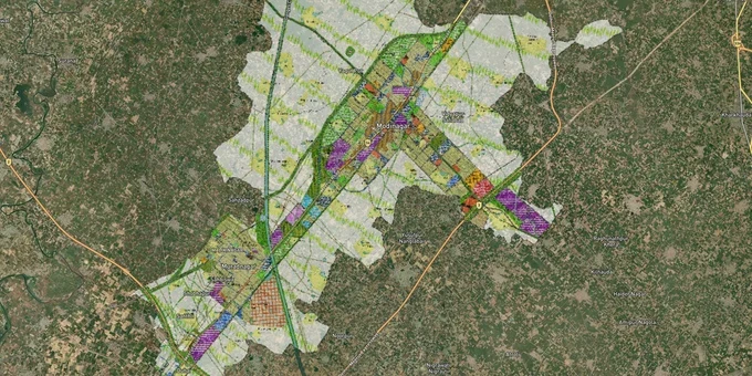
Modinagar Masterplan Preview
Try the Modinagar GDA Masterplan on the map
Sign in once and explore the layer for a full day.
- No card details needed
- Find nearby verified lands for sale
Overview
The Modinagar masterplan 2031 land zone plan is a GDA-prepared, GIS-based document covering 6,874.9 hectares across the Modinagar and Muradnagar planning area. The Ghaziabad Development Authority has board-approved the draft, but the UP government's gazette notification is still pending, which means the plan is not yet legally enforceable. It designates residential, commercial, industrial, recreational, and transit-oriented development zones, with TOD zones mapped within 1.5 km of both operational RRTS stations. This layer requires a Premium subscription on 1acre. This page covers zone rules, active demolition risks, and corridors with documented infrastructure backing.
Modinagar South, Modinagar North, and which corridors have real backing from RRTS and NCRTC
Two RRTS stations are now operational in Modinagar. Both Modinagar South and Modinagar North were inaugurated on 7 March 2024 as part of the 17 km Duhai–Modinagar North extension. The GDA masterplan draft designates TOD zones within 1.5 km of each station, and NCRTC has already invited commercial lease bids for 4,543 sq m at Modinagar South and 5,180 sq m at Modinagar North. These are the only two corridors with both operational transit and documented government commercial leasing on record.
The table below maps the active corridors against their planning status and known risks.
Corridor / Locality
Masterplan 2031 Zone
Growth Driver
Known Risk
Within 1.5 km of Modinagar South RRTS station
TOD Zone, Mixed Use, FAR 5 (proposed)
Operational RRTS; NCRTC commercial lease bids invited Dec 2024
FAR 5 not enforceable until UP gazette notification
Within 1.5 km of Modinagar North RRTS station
TOD Zone, Mixed Use, FAR 5 (proposed)
Operational RRTS; SRM University proximity at 2.8 km
Same gazette risk; verify colony license status separately
NH-58 / Delhi–Meerut Road corridor
Residential and Mixed Use
RRTS alignment follows NH-58; transit-facing frontage
Unauthorized layouts present beyond 1.5 km station zone
Didauli and surrounding village fringe
Agricultural / Residential fringe
None documented
Active demolition orders; GDA FIRs filed May 2025
Industrial zone parcels, Modinagar
Industrial
Existing industrial base
Full CLU required for residential conversion; not routine
The most misread corridor is NH-58 frontage beyond the two station influence zones. Sellers market it as "RRTS corridor land" at TOD pricing. Parcels more than 1.5 km from either station fall outside the designated TOD zone in the masterplan draft. Check the satellite map before accepting any price.
Was this layer helpful?
Anything wrong, outdated, or missing we want to hear it.
For Land Owners & Agents
Looking to sell your land in Delhi?
I want to sell my land in Delhi
10:32
Plz share your Land's location - We will list it on 1acre map, for Free.
10:32

For Land Buyers
Browse all verified lands & plots in Delhi NCR
Every listing goes through our Preliminary Verification Process.
More Layers in Delhi NCR
See all 30 layers
Alwar UIT Masterplan 2031: Zone Check and Land Use Guide
View Alwar Masterplan as a live map overlay – check any plot's land use zone for free on 1acre.in. Alwar Master Plan 205...
Arogya Dham Badsa Masterplan: Zone Check and Land Use Guide
View Arogya Dham Badsa Masterplan as a live map overlay – check any plot's land use zone for free on 1acre.in. Arogya Dh...

Baghpat Baraut Khekra Masterplan: Zone Check and Land Use Guide
View Bhagpat-Baraut-Khekra Masterplan as a live map overlay – check any plot's land use zone for free on 1acre.in. Baghp...
More Layers in Delhi NCR
Alwar UIT Masterplan 2031: Zone Check and Land Use Guide
View Alwar Masterplan as a live map overlay – check any plot's land use zone for free on 1acre.in. Alwar Master Plan 205...
Arogya Dham Badsa Masterplan: Zone Check and Land Use Guide
View Arogya Dham Badsa Masterplan as a live map overlay – check any plot's land use zone for free on 1acre.in. Arogya Dh...
Baghpat Baraut Khekra Masterplan: Zone Check and Land Use Guide
View Bhagpat-Baraut-Khekra Masterplan as a live map overlay – check any plot's land use zone for free on 1acre.in. Baghp...