Yamuna Expressway Masterplan: YEIDA Zone Check and Land Use Guide
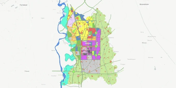
Yamuna Expressway Masterplan Preview
Try the Yamuna Expressway Masterplan on the map
Sign in once and explore the layer for a full day.
- No card details needed
- Find nearby verified lands for sale
Overview
The YEIDA Masterplan 2031 is the operative zoning document for the Yamuna Expressway corridor, prepared and enforced by the Yamuna Expressway Industrial Development Authority (YEIDA). Brought into effect in 2013, it demarcates 24,700 hectares for planned development across Phase 1 (Gautam Budh Nagar and Bulandshahr) and is designed for a target population of 35 lakhs by 2031. YEIDA's notified area spans approximately 2,689 sq km across six districts. A new Masterplan 2041 has been approved by the UP government but has not replaced the 2031 plan for existing transactions. This layer on 1acre, which requires a Premium subscription, maps every sector's YEIDA zone classification so buyers can verify land use before committing funds.
Airport Plots Fraud and the Abadi Zone Trap on the Yamuna Expressway
The Yamuna Expressway corridor has the most active "airport plots" fraud problem in the Delhi NCR region, and it is tightly tied to zone classification under the YEIDA Masterplan 2031. YEIDA's own enforcement operations demolished approximately ₹2,500 crore worth of illegal colonies in Jhajhar and Kakod villages near the Noida International Airport, where developers operating under names like Aeronest Coloniser, Shri Radha Gauri Enclave, and Rudra Properties were marketing plots with fabricated approval documents and false claims of YEIDA clearance.
The table below sets out the principal land use zones under the YEIDA Masterplan 2031 and the legal status of construction within each.
Zone
Area (ha)
Permitted Use
Construction Without YEIDA Approval
Notes
Residential
4,569.52 (19.5%)
Housing, plotted development
Not permissible
Sectors 16, 17, 18, 19, 20, 22, 22D; 90-year leasehold
Industrial
4,698.15 (20%)
Manufacturing, logistics, warehousing
Not permissible
Sectors 29, 32, 33, 34; key industrial belt
Green / Recreational
5,148.19 (21.9%)
Parks, green belts
Prohibited
Cannot be converted to residential
Commercial
1,275.12 (5.4%)
Retail, offices, shops (Sector 22D, 22E)
Not permissible
YEIDA e-auction required
Institutional
1,759.03 (7.5%)
IT/ITES (min. 10-acre plots), education, hospitals
Not permissible without YEIDA building sanction
Sector 22E corporate office zone
Mixed Use
1,370.23 (5.8%)
Residential plus commercial on major roads
Conditional; YEIDA plan approval required
Not applicable to village land
SDZ (Special Development Zone)
1,142.87 (4.9%)
Airport-related industries, aviation hub
Requires AAI NOC plus YEIDA sanction
Within 10 km Jewar Airport zone
Village Abadi
1,263.79
Village residential (pre-30 June 2011)
Prohibited for multi-storey without YEIDA regularisation
Highest fraud risk; governed by YEIDA's Rural Abadi Sites Regulations 2011
A formal construction ban within 10 km of the Noida International Airport was imposed by NIAL and the Gautam Budh Nagar district administration in July 2025, following an Airport Environment Management Committee (AEMC) meeting where airport COO Kiran Jain cited illegal buildings and stray animals as direct threats to aircraft safety. Under this regime, any construction without an NOC from the Airports Authority of India (AAI) and a building plan approved by YEIDA is illegal regardless of other documentation. YEIDA has stated explicitly: any land labelled "notified" that lacks an explicit YEIDA allotment letter cannot be legally transacted.
Additionally, roughly 55% of YEIDA Phase 2 falls within the Taj Trapezium Zone (TTZ), imposing Supreme Court-mandated pollution and industrial restrictions. Buyers in Phase 2 areas (Mathura, Aligarh, Hathras, Agra districts) must confirm that any industrial or commercial development complies with TTZ orders before proceeding.
Sector 18, 22D and the Industrial Belt: Where YEIDA Masterplan 2031 Zone Status Drives Value
Only four residential sectors along the Yamuna Expressway are directly on the main expressway alignment: Sectors 18, 19, 20, and 22. Sector 19 is the Jaypee sector, and Sector 22 is predominantly group housing. That leaves Sectors 18 and 20 as the only YEIDA-allotted plotted residential sectors on the expressway for the foreseeable future under the 2031 plan. No new residential sectors adjacent to the expressway are planned post-2021 under the current document. This supply constraint is the primary driver of price appreciation in these two sectors.
The table below maps the key YEIDA Masterplan 2031 corridors, their zone classification, and current investment status.
Sector / Corridor
Zone (Masterplan 2031)
Growth Driver
Known Risk
Sector 18, Pocket 9B
Residential
Proximity to Jewar Airport; consistent YEIDA plot scheme launches (RPS08, 2024–2026)
5-year possession delay after draw; leasehold 90 years
Sector 20
Residential (plotted)
One of only two YEIDA plotted sectors directly on expressway; steady capital appreciation
Underdeveloped social infrastructure; possession timeline linked to development completion
Sector 22D
Residential / Group Housing
ATS Allure, Ajnara; Logix and Orris allotted in this sector; highest existing project density
Premium pricing; transfer charges Rs 500–1,000 per sq m on resale
Sector 22E
Institutional / Corporate Office
YEIDA Corporate Office Plot Scheme 2024 launched; IT/ITES demand
Large minimum plot size; not suitable for individual buyers
Sectors 29, 32, 33, 34
Industrial
Logistics and warehousing growth; Dedicated Freight Corridor alignment; MSME/Apparel/Toy Park designated
Industrial zone: residential construction absolutely prohibited
Sector 22A
Group Housing
Ajnara Panorama; airport proximity; ready-to-move inventory
Group housing, not plotted; no direct YEIDA allotment for individuals
Sector 16C Extension
Residential (affordable)
Affordable plotted housing; Rudra Aqua Casa
Away from expressway alignment; weaker liquidity on resale
Sector 22D is the most commonly misunderstood zone. Brokers sell it as equivalent to Sectors 18 and 20 for plotted development, but it is predominantly a group housing and commercial zone. Individual plotted allotments here are the exception, not the rule. Verify the specific plot category against the YEIDA Masterplan 2031 sector map before treating any 22D plot as a standard residential allotment.
Was this layer helpful?
Anything wrong, outdated, or missing we want to hear it.
For Land Owners & Agents
Looking to sell your land in Delhi?
I want to sell my land in Delhi
10:32
Plz share your Land's location - We will list it on 1acre map, for Free.
10:32

For Land Buyers
Browse all verified lands & plots in Delhi NCR
Every listing goes through our Preliminary Verification Process.
More Layers in Delhi NCR
See all 30 layers
Alwar UIT Masterplan 2031: Zone Check and Land Use Guide
View Alwar Masterplan as a live map overlay – check any plot's land use zone for free on 1acre.in. Alwar Master Plan 205...
Arogya Dham Badsa Masterplan: Zone Check and Land Use Guide
View Arogya Dham Badsa Masterplan as a live map overlay – check any plot's land use zone for free on 1acre.in. Arogya Dh...

Baghpat Baraut Khekra Masterplan: Zone Check and Land Use Guide
View Bhagpat-Baraut-Khekra Masterplan as a live map overlay – check any plot's land use zone for free on 1acre.in. Baghp...
More Layers in Delhi NCR
Alwar UIT Masterplan 2031: Zone Check and Land Use Guide
View Alwar Masterplan as a live map overlay – check any plot's land use zone for free on 1acre.in. Alwar Master Plan 205...
Arogya Dham Badsa Masterplan: Zone Check and Land Use Guide
View Arogya Dham Badsa Masterplan as a live map overlay – check any plot's land use zone for free on 1acre.in. Arogya Dh...
Baghpat Baraut Khekra Masterplan: Zone Check and Land Use Guide
View Bhagpat-Baraut-Khekra Masterplan as a live map overlay – check any plot's land use zone for free on 1acre.in. Baghp...