Meerut MDA Masterplan 2031: Zone Check and Land Use Guide
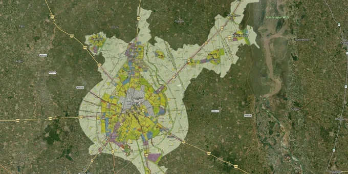
Meerut Masterplan Preview
Try the Meerut MDA Masterplan 2031 on the map
Sign in once and explore the layer for a full day.
- No card details needed
- Find nearby verified lands for sale
Overview
The Meerut Masterplan 2031 is the operative land-use plan for Meerut's development area, prepared and notified by the Meerut Development Authority (MDA) under the Uttar Pradesh Urban Planning and Development Act, 1973. Approved on 24 January 2024, the plan covers Meerut city and adjoining notified villages, spanning approximately 1,043 sq km, encompassing 305 villages. It is also the first masterplan in India to formally embed Transit-Oriented Development (TOD) zones. This page explains what the plan means for anyone buying a plot in Meerut, whose corridors carry real value, and which regulatory traps cost buyers most.
Modipuram, Partapur, Shatabdi Nagar: Where the Meerut Masterplan 2031 Creates Real Value
The Meerut Masterplan 2031 designates approximately 3,273 hectares for Transit-Oriented Development: 2,442 hectares across seven TOD zones around the Namo Bharat Regional Rapid Transit System (RRTS) and Meerut Metro corridors, with the remainder in two Special Development Areas. This is the most consequential land-value driver the plan introduces: high-density, mixed-use zoning within walkable distance of transit stations. Corridors without TOD designation carry a different risk profile entirely.
The table below maps the key investable corridors, their proximity to transit infrastructure, and the growth signal each carries under the 2031 plan.
Corridor
Transit Anchor
Zone Type
Price Signal
Known Risk
Modipuram
Namo Bharat terminal station
TOD / Residential
Flat prices up ~51% over 5 years (99acres transaction data)
Open land parcels, erratic power supply
Partapur
RRTS station, NH-58
TOD / Mixed Use
Demand surge, 750-acre township approved by UP government
Active developing phase, unfinished infrastructure
Shatabdi Nagar
Namo Bharat corridor proximity
Residential / TOD
Mid-range ₹40–80 lakh bracket, stable demand
Older MDA scheme stock
Mawana Road (NH-34)
No RRTS station
Residential fringe
Budget entry from ₹15 lakh, lower appreciation trajectory
Verify colony approval status before purchase
Modipuram is most frequently misunderstood. Land rates span ₹2,700–₹12,200 per sq ft depending on proximity to the RRTS terminal and MDA approval status of the specific colony. The spread is wide because MDA-approved stock and unauthorized developing colonies exist side by side along NH-58. Paying a premium for Modipuram land only makes sense if the colony layout is MDA-sanctioned and the survey number sits within the TOD zone as marked in the 2031 plan.
Was this layer helpful?
Anything wrong, outdated, or missing we want to hear it.
For Land Owners & Agents
Looking to sell your land in Delhi?
I want to sell my land in Delhi
10:32
Plz share your Land's location - We will list it on 1acre map, for Free.
10:32

For Land Buyers
Browse all verified lands & plots in Delhi NCR
Every listing goes through our Preliminary Verification Process.
More Layers in Delhi NCR
See all 30 layers
Alwar UIT Masterplan 2031: Zone Check and Land Use Guide
View Alwar Masterplan as a live map overlay – check any plot's land use zone for free on 1acre.in. Alwar Master Plan 205...
Arogya Dham Badsa Masterplan: Zone Check and Land Use Guide
View Arogya Dham Badsa Masterplan as a live map overlay – check any plot's land use zone for free on 1acre.in. Arogya Dh...

Baghpat Baraut Khekra Masterplan: Zone Check and Land Use Guide
View Bhagpat-Baraut-Khekra Masterplan as a live map overlay – check any plot's land use zone for free on 1acre.in. Baghp...
More Layers in Delhi NCR
Alwar UIT Masterplan 2031: Zone Check and Land Use Guide
View Alwar Masterplan as a live map overlay – check any plot's land use zone for free on 1acre.in. Alwar Master Plan 205...
Arogya Dham Badsa Masterplan: Zone Check and Land Use Guide
View Arogya Dham Badsa Masterplan as a live map overlay – check any plot's land use zone for free on 1acre.in. Arogya Dh...
Baghpat Baraut Khekra Masterplan: Zone Check and Land Use Guide
View Bhagpat-Baraut-Khekra Masterplan as a live map overlay – check any plot's land use zone for free on 1acre.in. Baghp...