Delhi Air Funnel Zones: Building Height Restrictions
Delhi Air Funnel Zones Preview
Try the Delhi Air Funnel Zones on the map
Sign in once and explore the layer for a full day.
- No card details needed
- Find nearby verified lands for sale
Overview
Delhi Air Funnel Zones layer on 1acre maps the Airports Authority of India (AAI) Colour Coded Zoning Map (CCZM) for the Indira Gandhi International Airport area. This layer is drawn from AAI's official CCZM, prepared under the Ministry of Civil Aviation Height Restrictions Rules 2015 (G.S.R. 751(E)). The CCZM covers a 20 km radius from the IGI aerodrome reference point and governs every structure within that area. This page explains which Delhi localities sit inside restriction zones, what the height caps mean for your build potential, and what clearances you must hold before signing a sale deed. This layer
IGI Airport Red Zone and Approach Funnel: The Height Traps That Kill Resale
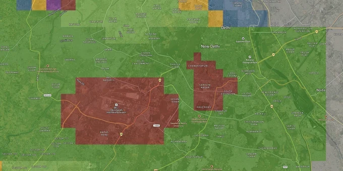
Two distinct restrictions operate around IGI, and confusing them costs buyers money. The red zone under the CCZM is the tighter ring: until 2020, the red zone covered 129 sq km around IGI, within which no structure above 18 m could be built without a mandatory AAI NOC. Following rule changes, the red zone area was reduced to 60 sq km, but the 18 m ceiling inside it remains unchanged. The approach funnel is more severe still, applying directly along the runway approach and departure paths. In the funnel, permitted height equals 2% of the distance from the runway edge: a plot 1,000 m from the runway edge is capped at just 20 m.
The CCZM divides the full 20 km radius into colour-coded grids, each carrying a Permissible Top Elevation (PTE) measured in metres above mean sea level (AMSL). The table below shows the key surface zones and what they mean for construction.
Zone / Surface
Distance from Runway Edge
Approximate Height Cap
AAI NOC Required?
Approach / Departure Funnel
Directly aligned with runway ends
2% of distance from runway edge
Yes, mandatory
Inner Horizontal Surface
Up to 4 km from aerodrome
45 m AGL
Yes, unless below CCZM PTE
Conical Surface
4 km to outer boundary
Increases gradually
Depends on CCZM grid
Red Zone (CCZM)
Approx. 60 sq km around IGI
18 m without NOC
Yes for anything above 18 m
General 20 km radius
Up to 20 km from aerodrome
Varies by grid
Yes; NOCAS auto-settles if below PTE
Delhi's CCZM threshold starts at just 7.77 m, meaning builders in this city need AAI approval for structures as low as a two-storey house in affected grids, far stricter than most other Indian cities. If a broker is showing you a plot in Dwarka, Mahipalpur, Kapashera, or Vasant Kunj without mentioning the CCZM grid reference for that survey number, treat that as a warning sign.
Where the Funnel Falls: Key Corridors and What Buyers Actually Face
The IGI airport funnel is not an abstraction; it has put construction on hold at specific addresses. AAI directed the DDA to halt construction at nearly 100 plots in Dwarka Sector 8 after determining the buildings fell inside the runway 27/9 and 28/10 approach paths. That is the clearest on-record example of the funnel ending a buyer's plans after purchase.
The table below maps the major Delhi corridors by their relationship to the funnel zones and what that means practically.
Corridor / Locality
Zone Relationship
Practical Constraint
Buyer Risk
Dwarka Sector 8
Directly in runway 27/9 & 28/10 approach path
Construction halted on record by AAI; DDA-issued NOC letters to plot owners
High: funnel zone directly overhead
Mahipalpur / Rangpuri
Inside red zone CCZM boundary
18 m hard ceiling; multi-storey construction requires AAI NOC
Medium-High: dense unregulated construction present
Kapashera / Bijwasan
Red zone perimeter; some grids in approach path
2-6 storey buildings can trigger NOC requirement
Medium: verify CCZM grid before any purchase
Vasant Kunj
Partial overlap; norms eased for high-rises after 2020
Higher-rise approvals easier now, but site-specific CCZM grid still governs
Medium: premium zone with complex layered clearances
Aerocity
Adjacent to airport boundary
Commercial use; primarily DIAL-governed approvals
Low for residential; high for commercial height
The most misunderstood corridor is Vasant Kunj. News of eased norms in 2020 led many buyers and brokers to assume height restrictions no longer apply. They do. Eased norms mean the red zone shrank and the online NOCAS system simplified approvals; they do not mean any plot in Vasant Kunj is free of height limits. Every plot still sits within a CCZM grid with its own PTE figure, and the lowest applicable surface restriction governs.
Was this layer helpful?
Anything wrong, outdated, or missing we want to hear it.
For Land Owners & Agents
Looking to sell your land in Delhi?
I want to sell my land in Delhi
10:32
Plz share your Land's location - We will list it on 1acre map, for Free.
10:32

For Land Buyers
Browse all verified lands & plots in Delhi NCR
Every listing goes through our Preliminary Verification Process.
More Layers in Delhi NCR
See all 30 layers
Delhi Master Plan 2041: DDA Zone Check and Land Use Guide
View Delhi Masterplan as a live map overlay – check any plot's land use zone for free on 1acre.in. Delhi masterplan land...

Alwar UIT Masterplan 2031: Zone Check and Land Use Guide
View Alwar Masterplan as a live map overlay – check any plot's land use zone for free on 1acre.in. Alwar Master Plan 205...
Arogya Dham Badsa Masterplan: Zone Check and Land Use Guide
View Arogya Dham Badsa Masterplan as a live map overlay – check any plot's land use zone for free on 1acre.in. Arogya Dh...
More Layers in Delhi NCR
Delhi Master Plan 2041: DDA Zone Check and Land Use Guide
View Delhi Masterplan as a live map overlay – check any plot's land use zone for free on 1acre.in. Delhi masterplan land...
Alwar UIT Masterplan 2031: Zone Check and Land Use Guide
View Alwar Masterplan as a live map overlay – check any plot's land use zone for free on 1acre.in. Alwar Master Plan 205...
Arogya Dham Badsa Masterplan: Zone Check and Land Use Guide
View Arogya Dham Badsa Masterplan as a live map overlay – check any plot's land use zone for free on 1acre.in. Arogya Dh...